Littleton Topo Map Colorado
To zoom in, hover over the map of Littleton
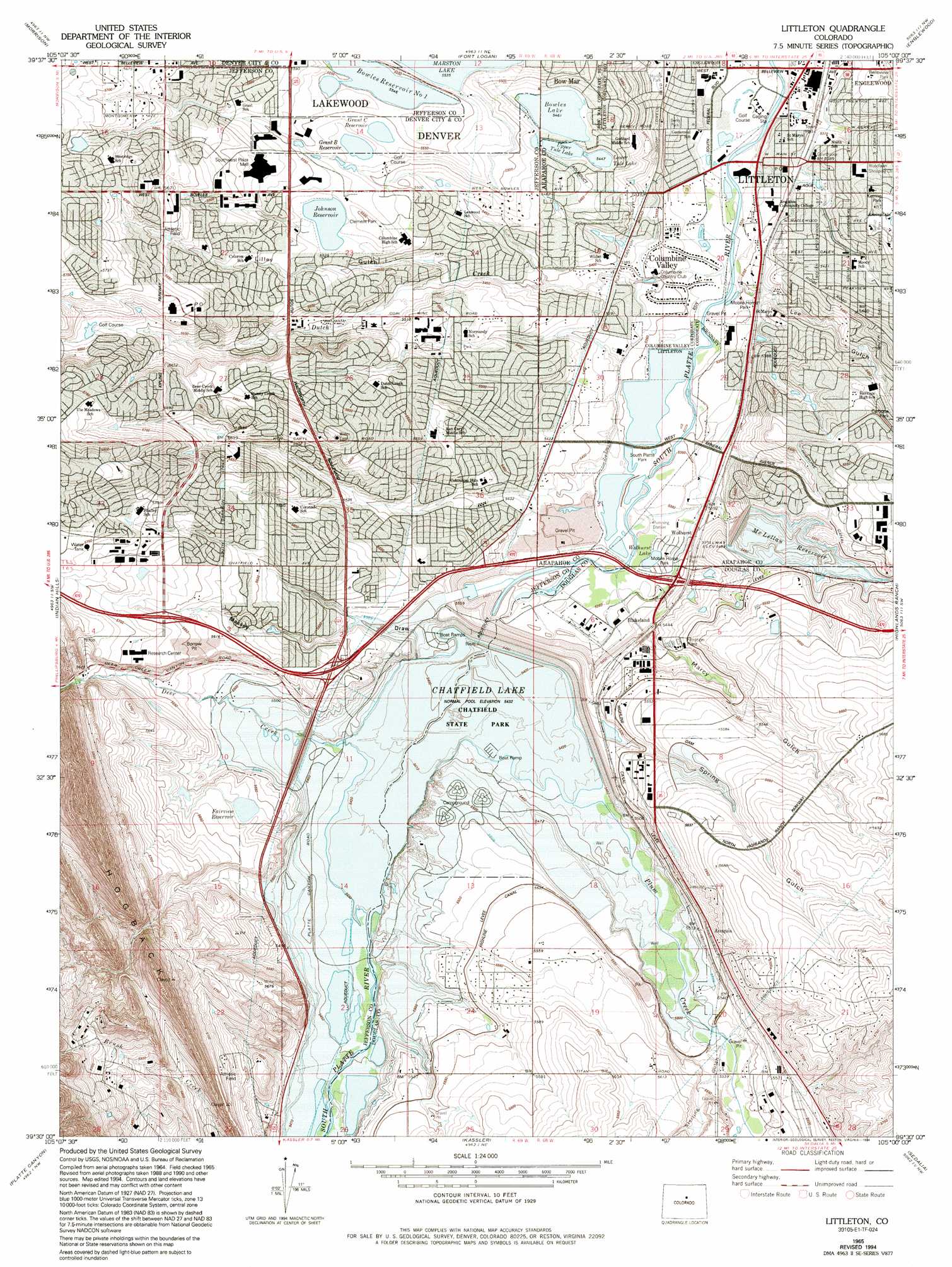
USGS Topo Quad 39105e1 - 1:24,000 scale
| Topo Map Name: | Littleton |
| USGS Topo Quad ID: | 39105e1 |
| Print Size: | ca. 21 1/4" wide x 27" high |
| Southeast Coordinates: | 39.5° N latitude / 105° W longitude |
| Map Center Coordinates: | 39.5625° N latitude / 105.0625° W longitude |
| U.S. State: | CO |
| Filename: | o39105e1.jpg |
| Download Map JPG Image: | Littleton topo map 1:24,000 scale |
| Map Type: | Topographic |
| Topo Series: | 7.5´ |
| Map Scale: | 1:24,000 |
| Source of Map Images: | United States Geological Survey (USGS) |
| Alternate Map Versions: |
Littleton CO 1942, updated 1950 Download PDF Buy paper map Littleton CO 1957, updated 1958 Download PDF Buy paper map Littleton CO 1957, updated 1961 Download PDF Buy paper map Littleton CO 1965, updated 1967 Download PDF Buy paper map Littleton CO 1965, updated 1973 Download PDF Buy paper map Littleton CO 1965, updated 1973 Download PDF Buy paper map Littleton CO 1965, updated 1980 Download PDF Buy paper map Littleton CO 1965, updated 1994 Download PDF Buy paper map Littleton CO 2011 Download PDF Buy paper map Littleton CO 2013 Download PDF Buy paper map Littleton CO 2016 Download PDF Buy paper map |
1:24,000 Topo Quads surrounding Littleton
Ralston Buttes |
Golden |
Arvada |
Commerce City |
Sable |
Evergreen |
Morrison |
Fort Logan |
Englewood |
Fitzsimons |
Conifer |
Indian Hills |
Littleton |
Highlands Ranch |
Parker |
Pine |
Platte Canyon |
Kassler |
Sedalia |
Castle Rock North |
Green Mountain |
Deckers |
Devils Head |
Dawson Butte |
Castle Rock South |
> Back to 39105e1 at 1:100,000 scale
> Back to 39104a1 at 1:250,000 scale
> Back to U.S. Topo Maps home
Littleton topo map: Gazetteer
Littleton: Airports
Bowen Farms Number 1 Airport elevation 1699m 5574′Chatfield Dam Heliport elevation 1690m 5544′
Columbine Airpark elevation 1730m 5675′
Littleton: Canals
Brown Ditch elevation 1622m 5321′Denver Municipal Aqueduct elevation 1694m 5557′
Fairview Ditch elevation 1704m 5590′
Nevada Ditch elevation 1639m 5377′
Platte Canyon Ditch elevation 1667m 5469′
Littleton: Dams
Beers Sisters Lake Dam elevation 1738m 5702′Bowles Number 1 Dam elevation 1665m 5462′
Chatfield Dam elevation 1668m 5472′
Fairview and Enlargement Dam elevation 1702m 5583′
Fairview Number 2 Dam elevation 1698m 5570′
J B 'B' Grant Dam elevation 1686m 5531′
Johnson Dam elevation 1685m 5528′
McLellan Dam elevation 1675m 5495′
Patrick Lake Dam elevation 1668m 5472′
Spring Gulch Dam elevation 1694m 5557′
Tule Lake Lower Dam elevation 1661m 5449′
Tule Lake Upper Dam elevation 1664m 5459′
Littleton: Lakes
Wolhurst Lake elevation 1638m 5374′Littleton: Mines
Brannan Pit Number Twelve elevation 1691m 5547′Chatfield Pit elevation 1691m 5547′
Clarke Pit elevation 1621m 5318′
Deer Creek Mine elevation 1748m 5734′
Deer Creek Pit elevation 1675m 5495′
Diamond Clay Mine elevation 1774m 5820′
Lariat Mine elevation 1798m 5898′
Littleton Pit elevation 1629m 5344′
New Hedley Mine elevation 1732m 5682′
Waterton Pit elevation 1798m 5898′
Littleton: Parks
Bega Park elevation 1635m 5364′Berry Park elevation 1628m 5341′
Blue Heron Park elevation 1737m 5698′
Bowles Grove Park elevation 1622m 5321′
Chatfield State Park elevation 1676m 5498′
Chaucer Park elevation 1738m 5702′
Cheif Colorow Park elevation 1700m 5577′
Christensen Meadows Park elevation 1726m 5662′
Clement Park elevation 1692m 5551′
Cody Street Park elevation 1702m 5583′
Columbine Hills Park elevation 1658m 5439′
Columbine Knolls Grove Park elevation 1668m 5472′
Columbine Sports Park elevation 1665m 5462′
Columbine Trail Park elevation 1657m 5436′
Columbine West Park elevation 1692m 5551′
Coronado Park elevation 1694m 5557′
Dakota Station Park elevation 1724m 5656′
Eagle Meadows Park elevation 1747m 5731′
Gallup Park elevation 1665m 5462′
Geneva Park elevation 1624m 5328′
Governor Grant Park elevation 1700m 5577′
Hamlet Park elevation 1659m 5442′
Harlow Park elevation 1638m 5374′
Ivan Thomas Greenway elevation 1638m 5374′
Jackass Hill Park elevation 1682m 5518′
James A Taylor Park elevation 1652m 5419′
Ken Caryl Ranch Community Park elevation 1738m 5702′
Leawood Park elevation 1678m 5505′
Lilly Gulch Park elevation 1711m 5613′
Lilly Pad Park elevation 1684m 5524′
Powderhorn Park elevation 1760m 5774′
Ridgeview Park elevation 1655m 5429′
South Platte Park elevation 1633m 5357′
Southbridge Park elevation 1691m 5547′
Sterne Park elevation 1637m 5370′
Valley View Park elevation 1724m 5656′
Valley Vista Park elevation 1647m 5403′
Wayside Meadows Park elevation 1677m 5501′
Weaver Park elevation 1662m 5452′
West Laurel Avenue Park elevation 1704m 5590′
Westbury Park elevation 1723m 5652′
Williamsburg Park elevation 1741m 5711′
Willow Creek Park elevation 1716m 5629′
Wingate South Park elevation 1700m 5577′
Woodmar Square Park elevation 1685m 5528′
Writers Vista Park elevation 1689m 5541′
Littleton: Populated Places
Acequia elevation 1694m 5557′Archer elevation 1657m 5436′
Blakeland elevation 1656m 5433′
Columbine elevation 1688m 5538′
Columbine Heights elevation 1655m 5429′
Columbine Hills elevation 1663m 5456′
Columbine Knolls elevation 1694m 5557′
Columbine Lakes elevation 1649m 5410′
Columbine Manor elevation 1656m 5433′
Columbine Valley elevation 1629m 5344′
Coventry elevation 1661m 5449′
Goldenwest Park elevation 1668m 5472′
Hillside Manor elevation 1656m 5433′
Ken Caryl elevation 1756m 5761′
Leawood elevation 1668m 5472′
Littleton elevation 1631m 5351′
Meadowbrook Heights elevation 1696m 5564′
Normandy Estates elevation 1675m 5495′
Ridgewood Park elevation 1649m 5410′
Southpark elevation 1671m 5482′
The Ridge At Stony Creek elevation 1724m 5656′
Wide Acres elevation 1639m 5377′
Wolhurst elevation 1637m 5370′
Littleton: Post Offices
Littleton Post Office elevation 1631m 5351′Littleton: Reservoirs
Beers Sisters Lake Reservoir elevation 1738m 5702′Blackrock Lake elevation 1633m 5357′
Blue Heron Lake elevation 1737m 5698′
Bowles Lake elevation 1665m 5462′
Bowles Reservoir Number One elevation 1693m 5554′
Bufflehead Lake elevation 1631m 5351′
Chatfield Lake elevation 1668m 5472′
Cooley Lake elevation 1629m 5344′
Eaglewatch Lake elevation 1633m 5357′
Fairview and Enlargement Reservoir elevation 1702m 5583′
Fairview Reservoir elevation 1694m 5557′
Fairview Reservoir Number 2 elevation 1698m 5570′
Grant A Lake elevation 1708m 5603′
Grant C Reservoir elevation 1690m 5544′
J B 'B' Grant Reservoir elevation 1686m 5531′
Johnson Reservoir elevation 1685m 5528′
Ladybug Lake elevation 1633m 5357′
Lower Tule Lake elevation 1661m 5449′
McLellan Reservoir elevation 1677m 5501′
McLellen Reservoir elevation 1675m 5495′
Patrick Lake elevation 1668m 5472′
Redtail Lake elevation 1631m 5351′
South Platte Reservoir elevation 1639m 5377′
Spring Gulch Reservoir elevation 1694m 5557′
Upper Tule Lake elevation 1664m 5459′
Littleton: Streams
Deer Creek elevation 1657m 5436′Dutch Creek elevation 1625m 5331′
Plum Creek elevation 1657m 5436′
Littleton: Valleys
Dad Clark Gulch elevation 1639m 5377′Deer Creek Canyon elevation 1709m 5606′
Lee Gulch elevation 1625m 5331′
Lilley Gulch elevation 1667m 5469′
Marcy Gulch elevation 1643m 5390′
Massey Draw elevation 1662m 5452′
Spring Gulch elevation 1679m 5508′
Sterling Gulch elevation 1683m 5521′
Littleton digital topo map on disk
Buy this Littleton topo map showing relief, roads, GPS coordinates and other geographical features, as a high-resolution digital map file on DVD: