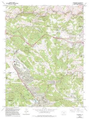
Evergreen Topo Map Colorado
To zoom in, hover over the map of Evergreen
USGS Topo Quad 39105f3 - 1:24,000 scale
| Topo Map Name: | Evergreen |
| USGS Topo Quad ID: | 39105f3 |
| Print Size: | ca. 21 1/4" wide x 27" high |
| Southeast Coordinates: | 39.625° N latitude / 105.25° W longitude |
| Map Center Coordinates: | 39.6875° N latitude / 105.3125° W longitude |
| U.S. State: | CO |
| Filename: | o39105f3.jpg |
| Download Map JPG Image: | Evergreen topo map 1:24,000 scale |
| Map Type: | Topographic |
| Topo Series: | 7.5´ |
| Map Scale: | 1:24,000 |
| Source of Map Images: | United States Geological Survey (USGS) |
| Alternate Map Versions: |
Evergreen CO 1957, updated 1958 Download PDF Buy paper map Evergreen CO 1960, updated 1960 Download PDF Buy paper map Evergreen CO 1965, updated 1967 Download PDF Buy paper map Evergreen CO 1965, updated 1967 Download PDF Buy paper map Evergreen CO 1965, updated 1973 Download PDF Buy paper map Evergreen CO 1965, updated 1980 Download PDF Buy paper map Evergreen CO 1965, updated 1988 Download PDF Buy paper map Evergreen CO 1965, updated 1994 Download PDF Buy paper map Evergreen CO 1965, updated 1994 Download PDF Buy paper map Evergreen CO 1971, updated 1973 Download PDF Buy paper map Evergreen CO 1994, updated 1994 Download PDF Buy paper map Evergreen CO 2011 Download PDF Buy paper map Evergreen CO 2013 Download PDF Buy paper map Evergreen CO 2016 Download PDF Buy paper map |
1:24,000 Topo Quads surrounding Evergreen
> Back to 39105e1 at 1:100,000 scale
> Back to 39104a1 at 1:250,000 scale
> Back to U.S. Topo Maps home
Evergreen topo map: Gazetteer
Evergreen: Airports
Indian Hills Fire Department Heliport elevation 2226m 7303′Evergreen: Crossings
Exit 251 elevation 2280m 7480′Exit 252 elevation 2342m 7683′
Exit 253 elevation 2337m 7667′
Exit 254 elevation 2358m 7736′
Exit 256 elevation 2178m 7145′
Evergreen: Dams
Evergreen Dam elevation 2157m 7076′Gayno Dam elevation 2272m 7454′
Genesee Sewage Treatment Dam elevation 2162m 7093′
Hiwan Number 1 Dam elevation 2312m 7585′
Hiwan Number 6 Dam elevation 2330m 7644′
Evergreen: Gaps
Dix Saddle elevation 2281m 7483′Evergreen: Mines
Bear Creek Quarry elevation 2235m 7332′Burroughs Feldspar Mine elevation 2157m 7076′
Capitol Central Mine elevation 2182m 7158′
Clear Creek Quarry elevation 2487m 8159′
Coors Pegmatite and Feldspar Quarry elevation 2351m 7713′
East Shaffer Hill Pegmatite Quarry elevation 2270m 7447′
Hiwan Ranch Pegmatite Quarry elevation 2244m 7362′
Roscoe Beryl Quarry elevation 2135m 7004′
Roscoe Prospect elevation 2031m 6663′
Seven Hills-Yetter Ranch Pegmatite Quarry elevation 2194m 7198′
Silver Glen Ranch Pegmatite Quarry elevation 2181m 7155′
Sunrise Peak Mine elevation 2272m 7454′
Sunrise Peak Pegmatite Quarry elevation 2315m 7595′
Swede-Kerr Gulches Pegmatite Quarries elevation 2201m 7221′
Tall Timber Number Three Pegmatite Quarry elevation 1888m 6194′
Wasson Beryl Deposit elevation 2431m 7975′
Wasson Ranch Pegmatite Quarry elevation 2431m 7975′
Evergreen: Parks
Alderfer/Three Sisters Park elevation 2347m 7700′Arrowhead Community Park elevation 2222m 7290′
Bergen Park elevation 2365m 7759′
Corwina Park elevation 2184m 7165′
Dedisse Park elevation 2197m 7208′
Elk Meadow Park elevation 2370m 7775′
Fillius Park elevation 2421m 7942′
Genesee Park elevation 2286m 7500′
Katherine Craig Park elevation 2354m 7723′
Lair o' the Bear Park elevation 2097m 6879′
O'Fallon Park elevation 2185m 7168′
Parmalee Gulch Park elevation 2176m 7139′
Pence Park elevation 2308m 7572′
Evergreen: Populated Places
Bergen Park elevation 2377m 7798′Cody Park elevation 2237m 7339′
El Rancho elevation 2304m 7559′
El Rancho elevation 2359m 7739′
Elephant Park elevation 2309m 7575′
Evergreen elevation 2150m 7053′
Genesee elevation 2331m 7647′
Genesee Ridge elevation 2286m 7500′
Hidden Valley elevation 2361m 7746′
Hiwan Hills elevation 2235m 7332′
Indians Hills elevation 2192m 7191′
Kittredge elevation 2105m 6906′
Mount Vernon Club Place elevation 2410m 7906′
Mountain Meadow Heights elevation 2150m 7053′
Paradise Hills elevation 2260m 7414′
Rainbow Hills elevation 2313m 7588′
Riva Chase elevation 2220m 7283′
Spring Ranch elevation 2303m 7555′
Troutdale elevation 2188m 7178′
Wah Keeney Park elevation 2276m 7467′
Evergreen: Reservoirs
Evergreen Lake elevation 2157m 7076′Gayno Reservoir elevation 2272m 7454′
Genesee Sewage Treatment Reservoir elevation 2162m 7093′
Hiwan Number 1 Reservoir elevation 2312m 7585′
Hiwan Number 6 Reservoir elevation 2330m 7644′
Evergreen: Springs
Charm Spring elevation 2244m 7362′Evergreen: Streams
Beaver Brook elevation 1951m 6400′Bergen Creek elevation 2219m 7280′
Buffalo Creek elevation 2180m 7152′
Cub Creek elevation 2157m 7076′
Elk Creek elevation 1981m 6499′
Little Cub Creek elevation 2174m 7132′
Soda Creek elevation 2182m 7158′
Troublesome Creek elevation 2093m 6866′
Wilmot Creek elevation 2158m 7080′
Evergreen: Summits
Bald Mountain elevation 2436m 7992′Elephant Butte elevation 2561m 8402′
Genesee Mountain elevation 2523m 8277′
Independence Mountain elevation 2539m 8330′
Jenkins Peak elevation 2417m 7929′
Lininger Mountain elevation 2360m 7742′
Evergreen: Trails
Beaver Brook Trail elevation 2157m 7076′Evergreen: Tunnels
Tunnel Number 1 elevation 1874m 6148′Tunnel Number 2 elevation 2080m 6824′
Tunnel Number 3 elevation 2054m 6738′
Evergreen: Valleys
Bear Gulch elevation 1998m 6555′Big Gulch elevation 2128m 6981′
Cold Spring Gulch elevation 2040m 6692′
Guy Gulch elevation 2024m 6640′
Kerr Gulch elevation 2140m 7020′
Myers Gulch elevation 2079m 6820′
Swede Gulch elevation 2080m 6824′
Evergreen digital topo map on disk
Buy this Evergreen topo map showing relief, roads, GPS coordinates and other geographical features, as a high-resolution digital map file on DVD:


