Loveland Pass Topo Map Colorado
To zoom in, hover over the map of Loveland Pass
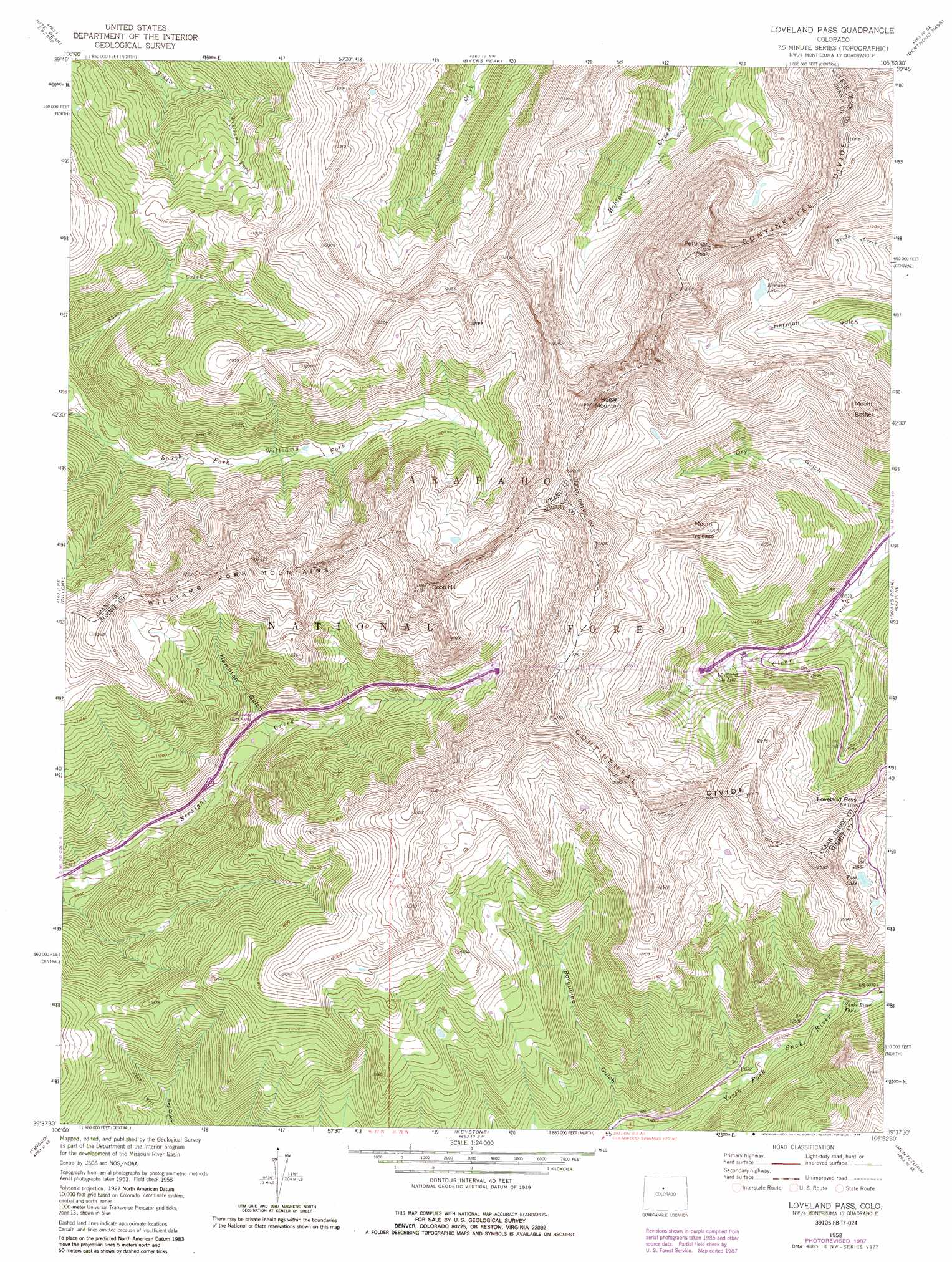
USGS Topo Quad 39105f8 - 1:24,000 scale
| Topo Map Name: | Loveland Pass |
| USGS Topo Quad ID: | 39105f8 |
| Print Size: | ca. 21 1/4" wide x 27" high |
| Southeast Coordinates: | 39.625° N latitude / 105.875° W longitude |
| Map Center Coordinates: | 39.6875° N latitude / 105.9375° W longitude |
| U.S. State: | CO |
| Filename: | o39105f8.jpg |
| Download Map JPG Image: | Loveland Pass topo map 1:24,000 scale |
| Map Type: | Topographic |
| Topo Series: | 7.5´ |
| Map Scale: | 1:24,000 |
| Source of Map Images: | United States Geological Survey (USGS) |
| Alternate Map Versions: |
Loveland Pass CO 1958, updated 1960 Download PDF Buy paper map Loveland Pass CO 1958, updated 1962 Download PDF Buy paper map Loveland Pass CO 1958, updated 1976 Download PDF Buy paper map Loveland Pass CO 1958, updated 1976 Download PDF Buy paper map Loveland Pass CO 1958, updated 1988 Download PDF Buy paper map Loveland Pass CO 2011 Download PDF Buy paper map Loveland Pass CO 2013 Download PDF Buy paper map Loveland Pass CO 2016 Download PDF Buy paper map |
| FStopo: | US Forest Service topo Loveland Pass is available: Download FStopo PDF Download FStopo TIF |
1:24,000 Topo Quads surrounding Loveland Pass
Battle Mountain |
Sylvan Reservoir |
Bottle Pass |
Fraser |
East Portal |
Squaw Creek |
Ute Peak |
Byers Peak |
Berthoud Pass |
Empire |
Willow Lakes |
Dillon |
Loveland Pass |
Grays Peak |
Georgetown |
Vail Pass |
Frisco |
Keystone |
Montezuma |
Mount Evans |
Copper Mountain |
Breckenridge |
Boreas Pass |
Jefferson |
Mount Logan |
> Back to 39105e1 at 1:100,000 scale
> Back to 39104a1 at 1:250,000 scale
> Back to U.S. Topo Maps home
Loveland Pass topo map: Gazetteer
Loveland Pass: Falls
Snake River Falls elevation 3232m 10603′Loveland Pass: Forests
Arapaho National Forest elevation 3625m 11893′Loveland Pass: Gaps
Loveland Pass elevation 3656m 11994′Loveland Pass: Lakes
Herman Lake elevation 3655m 11991′Pass Lake elevation 3607m 11833′
Loveland Pass: Mines
Franklin Mine elevation 3657m 11998′La Plata Mine elevation 3571m 11715′
Loveland Pass: Parks
Platte Park elevation 3676m 12060′Loveland Pass: Summits
Coon Hill elevation 3876m 12716′Hagar Mountain elevation 4020m 13188′
Mount Bethel elevation 3867m 12687′
Mount Trelease elevation 3798m 12460′
Pettingell Peak elevation 4104m 13464′
Loveland Pass: Trails
South Fork Trail elevation 3723m 12214′Loveland Pass: Tunnels
Eisenhower Memorial Tunnel elevation 3728m 12230′Loveland Pass: Valleys
Hamilton Gulch elevation 3149m 10331′No Name Gulch elevation 3183m 10442′
Porcupine Gulch elevation 3033m 9950′
Loveland Pass digital topo map on disk
Buy this Loveland Pass topo map showing relief, roads, GPS coordinates and other geographical features, as a high-resolution digital map file on DVD: