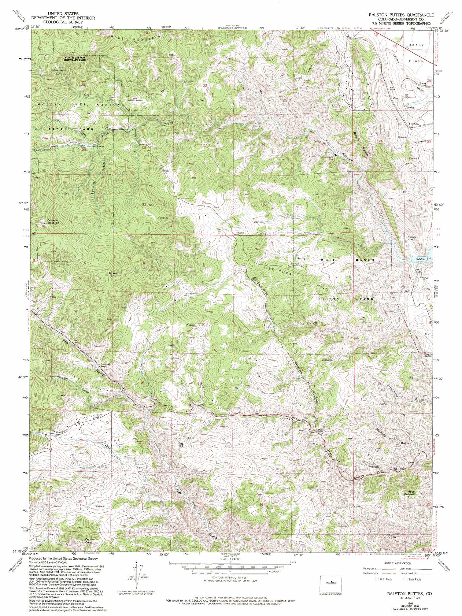
Ralston Buttes Topo Map Colorado
To zoom in, hover over the map of Ralston Buttes
USGS Topo Quad 39105g3 - 1:24,000 scale
| Topo Map Name: | Ralston Buttes |
| USGS Topo Quad ID: | 39105g3 |
| Print Size: | ca. 21 1/4" wide x 27" high |
| Southeast Coordinates: | 39.75° N latitude / 105.25° W longitude |
| Map Center Coordinates: | 39.8125° N latitude / 105.3125° W longitude |
| U.S. State: | CO |
| Filename: | o39105g3.jpg |
| Download Map JPG Image: | Ralston Buttes topo map 1:24,000 scale |
| Map Type: | Topographic |
| Topo Series: | 7.5´ |
| Map Scale: | 1:24,000 |
| Source of Map Images: | United States Geological Survey (USGS) |
| Alternate Map Versions: |
Ralston Buttes CO 1942, updated 1957 Download PDF Buy paper map Ralston Buttes CO 1948 Download PDF Buy paper map Ralston Buttes CO 1965, updated 1967 Download PDF Buy paper map Ralston Buttes CO 1965, updated 1967 Download PDF Buy paper map Ralston Buttes CO 1965, updated 1973 Download PDF Buy paper map Ralston Buttes CO 1965, updated 1973 Download PDF Buy paper map Ralston Buttes CO 1965, updated 1984 Download PDF Buy paper map Ralston Buttes CO 1965, updated 1992 Download PDF Buy paper map Ralston Buttes CO 1965, updated 1994 Download PDF Buy paper map Ralston Buttes CO 1965, updated 1994 Download PDF Buy paper map Ralston Buttes CO 2011 Download PDF Buy paper map Ralston Buttes CO 2013 Download PDF Buy paper map Ralston Buttes CO 2016 Download PDF Buy paper map |
1:24,000 Topo Quads surrounding Ralston Buttes
Ward |
Gold Hill |
Boulder |
Niwot |
Erie |
Nederland |
Tunsgten |
Eldorado Springs |
Louisville |
Lafayette |
Central City |
Black Hawk |
Ralston Buttes |
Golden |
Arvada |
Idaho Springs |
Squaw Pass |
Evergreen |
Morrison |
Fort Logan |
Harris Park |
Meridian Hill |
Conifer |
Indian Hills |
Littleton |
> Back to 39105e1 at 1:100,000 scale
> Back to 39104a1 at 1:250,000 scale
> Back to U.S. Topo Maps home
Ralston Buttes topo map: Gazetteer
Ralston Buttes: Airports
Schwartzwalder Heliport elevation 2007m 6584′Ralston Buttes: Mines
Ascension Mine elevation 2116m 6942′Aubrey Ladwig Mine elevation 2154m 7066′
B Gilman Ranch Pegmatite Mine elevation 2419m 7936′
Bachman Ranch Pegmatite Mine elevation 2394m 7854′
Cervi Lease Mine elevation 2116m 6942′
Coors Quarry elevation 2872m 9422′
Cressmans Gulch Mine elevation 2112m 6929′
Drew Hill Pegmatite Mine Number One elevation 2495m 8185′
Elledge Beryl Prospect Mine elevation 2271m 7450′
Fork Prospect Mine elevation 2013m 6604′
Fred Pierce Ranch Mine elevation 2228m 7309′
Grosso Mine elevation 2130m 6988′
Hoffmeister Uranium Prospect Mine elevation 2292m 7519′
Johnson Mine elevation 2455m 8054′
Johnson Number Two Mine elevation 1919m 6295′
K L Green Ranch Pegmatite Mine elevation 2493m 8179′
Ladwig Number Two Mine elevation 1900m 6233′
Ladwig Ranch Pegmatite Mine elevation 2242m 7355′
Ladwig-Grosso Pegmatite Mine elevation 2137m 7011′
Little Abner Pegmatite Mine elevation 2392m 7847′
Mena Mine elevation 2084m 6837′
Murphy Mine elevation 1901m 6236′
Ohman Mine elevation 2096m 6876′
Ramstetter Ranch Mine elevation 2324m 7624′
Robinson Gulch Mine elevation 2427m 7962′
S B Strang Ralston Creek Pegmatite Mine elevation 2410m 7906′
Shewartzwalder Mine elevation 2023m 6637′
U P Shaft Mine elevation 2048m 6719′
Wilson Clay Mine elevation 1949m 6394′
Ralston Buttes: Streams
Deer Creek elevation 2253m 7391′Nott Creek elevation 2330m 7644′
Ralston Buttes: Summits
Belcher Hill elevation 2477m 8126′Centennial Cone elevation 2640m 8661′
Centralia Mountain elevation 2982m 9783′
Grannys Head elevation 2688m 8818′
Guy Hill elevation 2468m 8097′
Mount Galbraith elevation 2209m 7247′
Mount Tom elevation 2969m 9740′
Ralston Buttes elevation 2222m 7290′
Ralston Buttes: Valleys
Crawford Gulch elevation 2105m 6906′Halfmile Gulch elevation 1900m 6233′
Robinson Gulch elevation 2279m 7477′
Sawmill Gulch elevation 2333m 7654′
Ralston Buttes digital topo map on disk
Buy this Ralston Buttes topo map showing relief, roads, GPS coordinates and other geographical features, as a high-resolution digital map file on DVD: