Berthoud Pass Topo Map Colorado
To zoom in, hover over the map of Berthoud Pass
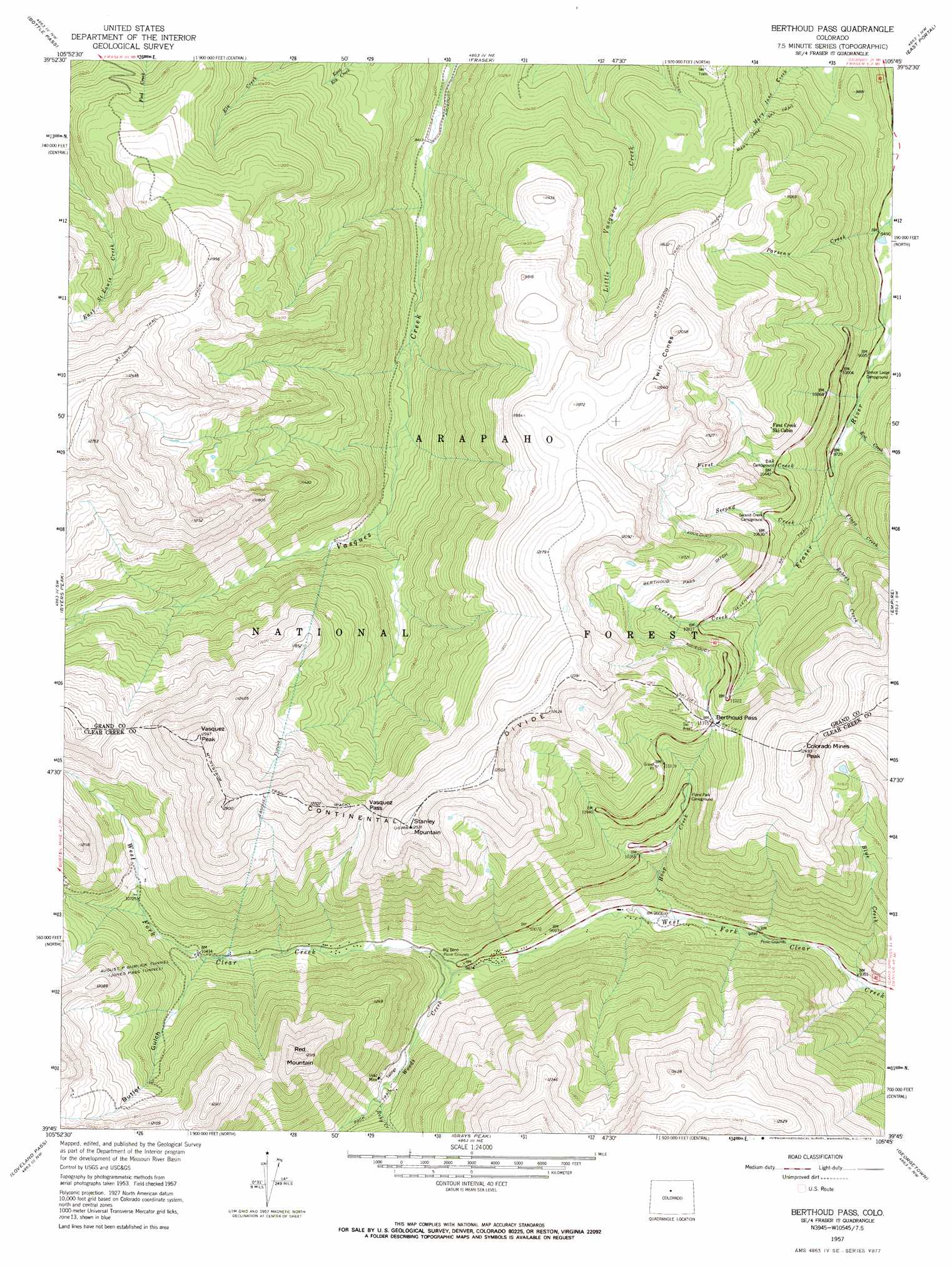
USGS Topo Quad 39105g7 - 1:24,000 scale
| Topo Map Name: | Berthoud Pass |
| USGS Topo Quad ID: | 39105g7 |
| Print Size: | ca. 21 1/4" wide x 27" high |
| Southeast Coordinates: | 39.75° N latitude / 105.75° W longitude |
| Map Center Coordinates: | 39.8125° N latitude / 105.8125° W longitude |
| U.S. State: | CO |
| Filename: | o39105g7.jpg |
| Download Map JPG Image: | Berthoud Pass topo map 1:24,000 scale |
| Map Type: | Topographic |
| Topo Series: | 7.5´ |
| Map Scale: | 1:24,000 |
| Source of Map Images: | United States Geological Survey (USGS) |
| Alternate Map Versions: |
Berthoud Pass CO 1957, updated 1959 Download PDF Buy paper map Berthoud Pass CO 1957, updated 1959 Download PDF Buy paper map Berthoud Pass CO 1957, updated 1964 Download PDF Buy paper map Berthoud Pass CO 1957, updated 1964 Download PDF Buy paper map Berthoud Pass CO 1957, updated 1973 Download PDF Buy paper map Berthoud Pass CO 1957, updated 1973 Download PDF Buy paper map Berthoud Pass CO 2011 Download PDF Buy paper map Berthoud Pass CO 2013 Download PDF Buy paper map Berthoud Pass CO 2016 Download PDF Buy paper map |
| FStopo: | US Forest Service topo Berthoud Pass is available: Download FStopo PDF Download FStopo TIF |
1:24,000 Topo Quads surrounding Berthoud Pass
Hot Sulpher Springs |
Granby |
Strawberry Lake |
Monarch Lake |
Ward |
Sylvan Reservoir |
Bottle Pass |
Fraser |
East Portal |
Nederland |
Ute Peak |
Byers Peak |
Berthoud Pass |
Empire |
Central City |
Dillon |
Loveland Pass |
Grays Peak |
Georgetown |
Idaho Springs |
Frisco |
Keystone |
Montezuma |
Mount Evans |
Harris Park |
> Back to 39105e1 at 1:100,000 scale
> Back to 39104a1 at 1:250,000 scale
> Back to U.S. Topo Maps home
Berthoud Pass topo map: Gazetteer
Berthoud Pass: Airports
Berthoud Pass Heliport elevation 3787m 12424′Henderson Heliport elevation 3192m 10472′
Henderson Mine Heliport elevation 3169m 10396′
Berthoud Pass: Canals
Berthoud Pass Ditch elevation 3440m 11286′Berthoud Pass: Dams
Fraser River Diversion Dam elevation 2873m 9425′Jefferson Lake Dam elevation 3664m 12020′
Berthoud Pass: Gaps
Berthoud Pass elevation 3452m 11325′Vasquez Pass elevation 3564m 11692′
Berthoud Pass: Lakes
Blue Lake elevation 3535m 11597′Berthoud Pass: Mines
Archibell Mine elevation 3421m 11223′Barton Mine elevation 2938m 9639′
Bellview Hudson Tunnel elevation 3603m 11820′
Big Esther Mine elevation 3462m 11358′
Doctor Mine elevation 2988m 9803′
Henderson Mine elevation 3182m 10439′
Jean Mine elevation 3632m 11916′
Jim Lode Mine elevation 3292m 10800′
John L Frannie Mine elevation 3150m 10334′
Jury Mine elevation 3108m 10196′
Scotia Mine elevation 3281m 10764′
Scott Mine elevation 3306m 10846′
Urad Mine elevation 3126m 10255′
Wyoming Mine elevation 3097m 10160′
Berthoud Pass: Populated Places
Berthoud Falls elevation 2985m 9793′Berthoud Pass: Reservoirs
Jefferson Lake elevation 3664m 12020′Berthoud Pass: Streams
Blue Creek elevation 2835m 9301′Current Creek elevation 3180m 10433′
Eva Creek elevation 2950m 9678′
First Creek elevation 2964m 9724′
Flora Creek elevation 2991m 9812′
Hoop Creek elevation 2914m 9560′
Parsenn Creek elevation 2886m 9468′
Robert Creek elevation 3047m 9996′
Ruby Creek elevation 3110m 10203′
Second Creek elevation 3005m 9858′
Woods Creek elevation 3005m 9858′
Berthoud Pass: Summits
Colorado Mines Peak elevation 3777m 12391′Red Mountain elevation 3748m 12296′
Stanley Mountain elevation 3819m 12529′
Twin Cones elevation 3673m 12050′
Vasquez Peak elevation 3944m 12939′
Berthoud Pass: Trails
Mary Jane Ski Trail elevation 3005m 9858′Mount Nystrom Trail elevation 3761m 12339′
Sevenmile Ski Trail elevation 3153m 10344′
Berthoud Pass: Tunnels
Vasquez Tunnel elevation 3653m 11984′Berthoud Pass: Valleys
Butler Gulch elevation 3177m 10423′Berthoud Pass digital topo map on disk
Buy this Berthoud Pass topo map showing relief, roads, GPS coordinates and other geographical features, as a high-resolution digital map file on DVD: