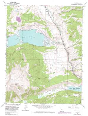
Granite Topo Map Colorado
To zoom in, hover over the map of Granite
USGS Topo Quad 39106a3 - 1:24,000 scale
| Topo Map Name: | Granite |
| USGS Topo Quad ID: | 39106a3 |
| Print Size: | ca. 21 1/4" wide x 27" high |
| Southeast Coordinates: | 39° N latitude / 106.25° W longitude |
| Map Center Coordinates: | 39.0625° N latitude / 106.3125° W longitude |
| U.S. State: | CO |
| Filename: | o39106a3.jpg |
| Download Map JPG Image: | Granite topo map 1:24,000 scale |
| Map Type: | Topographic |
| Topo Series: | 7.5´ |
| Map Scale: | 1:24,000 |
| Source of Map Images: | United States Geological Survey (USGS) |
| Alternate Map Versions: |
Granite CO 1967, updated 1972 Download PDF Buy paper map Granite CO 1967, updated 1972 Download PDF Buy paper map Granite CO 1967, updated 1983 Download PDF Buy paper map Granite CO 1994, updated 2001 Download PDF Buy paper map Granite CO 2011 Download PDF Buy paper map Granite CO 2013 Download PDF Buy paper map Granite CO 2016 Download PDF Buy paper map |
| FStopo: | US Forest Service topo Granite is available: Download FStopo PDF Download FStopo TIF |
1:24,000 Topo Quads surrounding Granite
> Back to 39106a1 at 1:100,000 scale
> Back to 39106a1 at 1:250,000 scale
> Back to U.S. Topo Maps home
Granite topo map: Gazetteer
Granite: Airports
Granite Heliport elevation 3058m 10032′Granite: Dams
Mount Elbert Forebay Dam elevation 2939m 9642′Twin Lakes Dam elevation 2806m 9206′
Granite: Mines
Aztec Mine elevation 2726m 8943′Bell of Granite Mine elevation 2726m 8943′
Betsy Mine elevation 2726m 8943′
Buck Mine elevation 2726m 8943′
Cache Creek Mine elevation 2726m 8943′
Columbine Mine elevation 3758m 12329′
Curlew Placer Mine elevation 2890m 9481′
Driscoll Mine elevation 2726m 8943′
Eleven O'Clock Mine elevation 2726m 8943′
Florence Extension Mine elevation 2761m 9058′
Franklin Mine elevation 2726m 8943′
Gold Basin Mine elevation 2726m 8943′
Gold Bottom Placer Mine elevation 2726m 8943′
Gold Run Mine elevation 2726m 8943′
Golden Cache Mine elevation 2726m 8943′
Good Hope Mine elevation 2726m 8943′
H and H Mine elevation 2726m 8943′
Hayden Placer Mine elevation 2726m 8943′
Independent Mine elevation 2726m 8943′
International Mine elevation 2726m 8943′
Josephine Mine elevation 2726m 8943′
Little Troy Mine elevation 2726m 8943′
Luna Placer Mine elevation 2800m 9186′
Magenta Mine elevation 2737m 8979′
Mount Harvard Mine elevation 2726m 8943′
New Year Mine elevation 2737m 8979′
Pantle Mine elevation 2856m 9370′
Penn Nevada Dredge Mine elevation 2726m 8943′
Pennsylvania Placer elevation 2858m 9376′
Placer Mines elevation 2919m 9576′
Raeanna Mine elevation 2856m 9370′
Savage Placer Mine elevation 2879m 9445′
Smith-Bullard Mine elevation 2830m 9284′
Smuggler Mine elevation 2726m 8943′
Spring Mine elevation 2726m 8943′
Tiger Lilly Mine elevation 2737m 8979′
Tom Thumb Mine elevation 2877m 9438′
Trafalgar Mine elevation 2726m 8943′
U S Dredge Mine elevation 2856m 9370′
Washington Mine elevation 2737m 8979′
Young America Placer Mine elevation 2726m 8943′
Granite: Populated Places
Balltown elevation 2755m 9038′Granite elevation 2747m 9012′
Granite: Reservoirs
Mount Elbert Forebay elevation 2939m 9642′Twin Lakes elevation 2806m 9206′
Twin Lakes Reservoir elevation 2794m 9166′
Granite: Streams
Box Creek elevation 2777m 9110′Cache Creek elevation 2724m 8937′
Flume Creek elevation 2806m 9206′
Lake Creek elevation 2756m 9041′
Spring Creek elevation 2749m 9019′
Granite: Valleys
Bartlett Gulch elevation 2805m 9202′Belford Gulch elevation 2841m 9320′
Columbia Gulch elevation 2912m 9553′
Hawkinsville Gulch elevation 2732m 8963′
Hayden Gulch elevation 2743m 8999′
Holmes Gulch elevation 2775m 9104′
Kellog Gulch elevation 2751m 9025′
Lost Canyon elevation 2936m 9632′
Low Pass Gulch elevation 2733m 8966′
Sawmill Gulch elevation 2793m 9163′
Sheephead Gulch elevation 2847m 9340′
Twobit Gulch elevation 2779m 9117′
Waverly Gulch elevation 2817m 9242′
Granite digital topo map on disk
Buy this Granite topo map showing relief, roads, GPS coordinates and other geographical features, as a high-resolution digital map file on DVD:


