Independence Pass Topo Map Colorado
To zoom in, hover over the map of Independence Pass
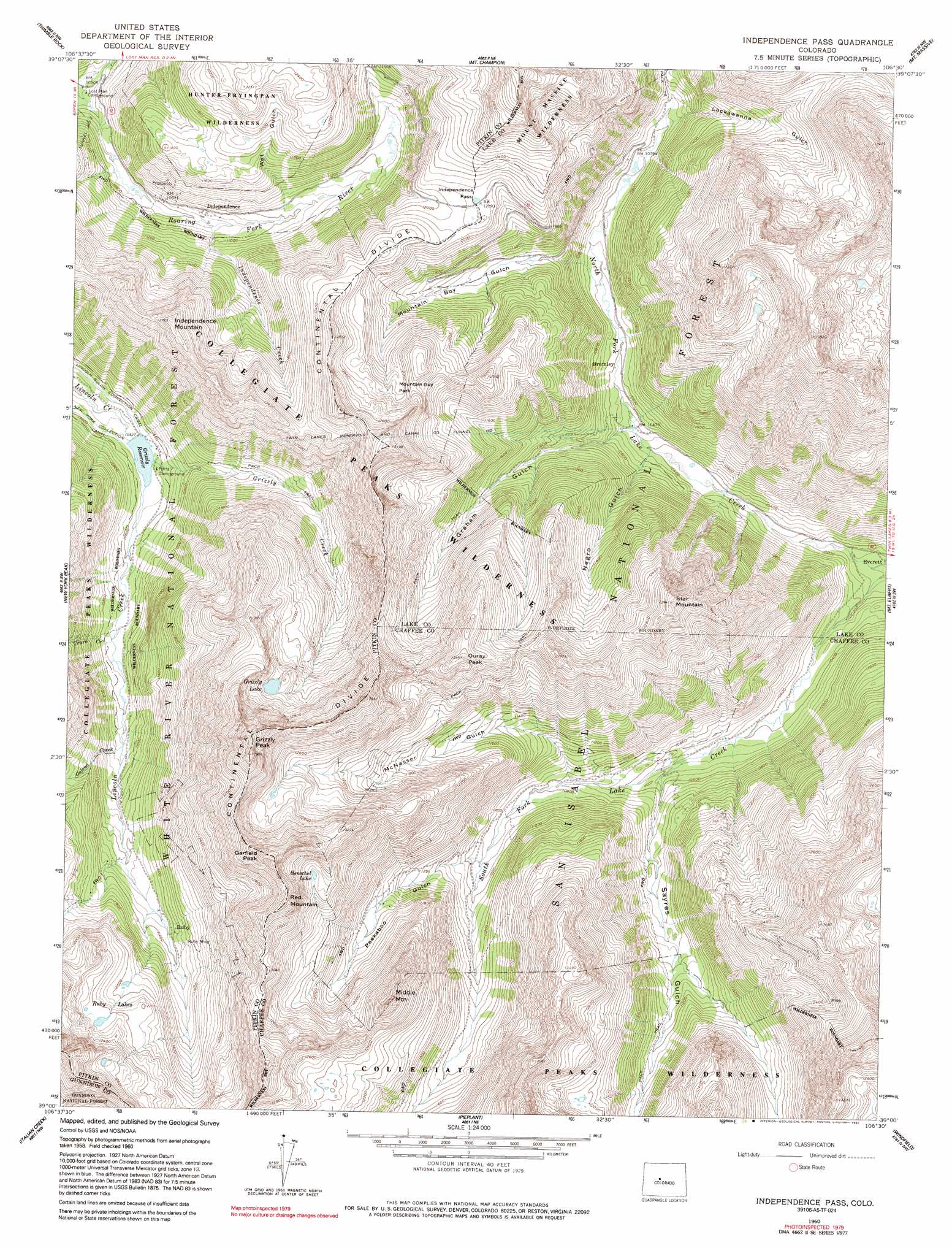
USGS Topo Quad 39106a5 - 1:24,000 scale
| Topo Map Name: | Independence Pass |
| USGS Topo Quad ID: | 39106a5 |
| Print Size: | ca. 21 1/4" wide x 27" high |
| Southeast Coordinates: | 39° N latitude / 106.5° W longitude |
| Map Center Coordinates: | 39.0625° N latitude / 106.5625° W longitude |
| U.S. State: | CO |
| Filename: | o39106a5.jpg |
| Download Map JPG Image: | Independence Pass topo map 1:24,000 scale |
| Map Type: | Topographic |
| Topo Series: | 7.5´ |
| Map Scale: | 1:24,000 |
| Source of Map Images: | United States Geological Survey (USGS) |
| Alternate Map Versions: |
Independence Pass CO 1960, updated 1965 Download PDF Buy paper map Independence Pass CO 1960, updated 1965 Download PDF Buy paper map Independence Pass CO 1960, updated 1968 Download PDF Buy paper map Independence Pass CO 1960, updated 1975 Download PDF Buy paper map Independence Pass CO 1960, updated 1991 Download PDF Buy paper map Independence Pass CO 1994, updated 1998 Download PDF Buy paper map Independence Pass CO 2011 Download PDF Buy paper map Independence Pass CO 2013 Download PDF Buy paper map Independence Pass CO 2016 Download PDF Buy paper map |
| FStopo: | US Forest Service topo Independence Pass is available: Download FStopo PDF Download FStopo TIF |
1:24,000 Topo Quads surrounding Independence Pass
Ruedi |
Meredith |
Nast |
Homestake Reservoir |
Leadville North |
Aspen |
Thimble Rock |
Mount Champion |
Mount Massive |
Leadville South |
Hayden Peak |
New York Peak |
Independence Pass |
Mount Elbert |
Granite |
Pearl Pass |
Italian Creek |
Pieplant |
Winfield |
Mount Harvard |
Cement Mountain |
Matchless Mountain |
Taylor Park Reservoir |
Tincup |
Mount Yale |
> Back to 39106a1 at 1:100,000 scale
> Back to 39106a1 at 1:250,000 scale
> Back to U.S. Topo Maps home
Independence Pass topo map: Gazetteer
Independence Pass: Dams
Grizzly Reservoir Dam elevation 3213m 10541′Independence Pass: Flats
Mountain Boy Park elevation 3704m 12152′Independence Pass: Gaps
Independence Pass elevation 3689m 12103′Independence Pass: Lakes
Grizzly Lake elevation 3810m 12500′Henschel Lake elevation 3851m 12634′
Ruby Lakes elevation 3667m 12030′
Independence Pass: Mines
Bwlchgoch Mine elevation 3492m 11456′Detroit Mine elevation 3904m 12808′
Lincoln Mining District Mine elevation 3500m 11482′
Lone Star Mine elevation 3649m 11971′
Mountain Boy Mine elevation 3746m 12290′
Ruby Mine elevation 3571m 11715′
Saturday Night Mine elevation 3518m 11541′
The Burge Group Mine elevation 3535m 11597′
Independence Pass: Populated Places
Brumley (historical) elevation 3233m 10606′Everett elevation 3084m 10118′
Independence (historical) elevation 3326m 10912′
Ruby (historical) elevation 3469m 11381′
Independence Pass: Reservoirs
Grizzly Reservoir elevation 3213m 10541′Independence Pass: Ridges
Continental Divide elevation 3914m 12841′Independence Pass: Streams
Galena Creek elevation 3322m 10898′Grizzly Creek elevation 3213m 10541′
Independence Creek elevation 3306m 10846′
South Fork Lake Creek elevation 3072m 10078′
Truro Creek elevation 3269m 10725′
Independence Pass: Summits
Garfield Peak elevation 4193m 13756′Grizzly Peak elevation 4258m 13969′
Independence Mountain elevation 3861m 12667′
Middle Mountain elevation 3992m 13097′
Ouray Peak elevation 3934m 12906′
Red Mountain elevation 4090m 13418′
Star Mountain elevation 3938m 12919′
Independence Pass: Tunnels
Twin Lakes Reservoir and Canal Company Tunnel Number 1 elevation 4003m 13133′Independence Pass: Valleys
Graham Gulch elevation 3196m 10485′Lackawanna Gulch elevation 3301m 10830′
McNasser Gulch elevation 3282m 10767′
Mountain Boy Gulch elevation 3257m 10685′
Negro Gulch elevation 3172m 10406′
Peekaboo Gulch elevation 3344m 10971′
Sayres Gulch elevation 3194m 10479′
Wet Gulch elevation 3354m 11003′
Independence Pass digital topo map on disk
Buy this Independence Pass topo map showing relief, roads, GPS coordinates and other geographical features, as a high-resolution digital map file on DVD: