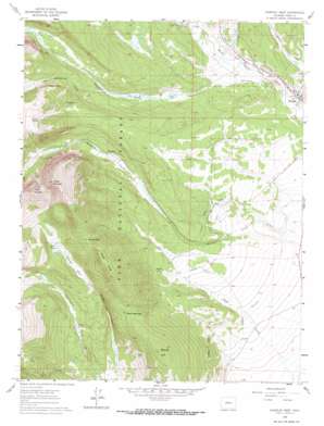
Fairplay West Topo Map Colorado
To zoom in, hover over the map of Fairplay West
USGS Topo Quad 39106b1 - 1:24,000 scale
| Topo Map Name: | Fairplay West |
| USGS Topo Quad ID: | 39106b1 |
| Print Size: | ca. 21 1/4" wide x 27" high |
| Southeast Coordinates: | 39.125° N latitude / 106° W longitude |
| Map Center Coordinates: | 39.1875° N latitude / 106.0625° W longitude |
| U.S. State: | CO |
| Filename: | o39106b1.jpg |
| Download Map JPG Image: | Fairplay West topo map 1:24,000 scale |
| Map Type: | Topographic |
| Topo Series: | 7.5´ |
| Map Scale: | 1:24,000 |
| Source of Map Images: | United States Geological Survey (USGS) |
| Alternate Map Versions: |
Fairplay West CO 1960, updated 1963 Download PDF Buy paper map Fairplay West CO 1960, updated 1963 Download PDF Buy paper map Fairplay West CO 1960, updated 1967 Download PDF Buy paper map Fairplay West CO 1960, updated 1967 Download PDF Buy paper map Fairplay West CO 1994, updated 1998 Download PDF Buy paper map Fairplay West CO 2011 Download PDF Buy paper map Fairplay West CO 2013 Download PDF Buy paper map Fairplay West CO 2016 Download PDF Buy paper map |
| FStopo: | US Forest Service topo Fairplay West is available: Download FStopo PDF Download FStopo TIF |
1:24,000 Topo Quads surrounding Fairplay West
> Back to 39106a1 at 1:100,000 scale
> Back to 39106a1 at 1:250,000 scale
> Back to U.S. Topo Maps home
Fairplay West topo map: Gazetteer
Fairplay West: Airports
Sacramento Heliport elevation 3390m 11122′Fairplay West: Canals
Columbia Number 1 Ditch elevation 3123m 10246′Fairplay Mining Ditch elevation 3088m 10131′
Fourmile Number 9 Ditch elevation 2991m 9812′
High Creek Ditch elevation 3040m 9973′
Peart Lower Ditch elevation 3032m 9947′
Peart Upper Ditch elevation 3072m 10078′
Placer Ditch elevation 3070m 10072′
Rogers Ditch elevation 2981m 9780′
Warm Springs Ditch elevation 3056m 10026′
Westerman Ditch elevation 3075m 10088′
Fairplay West: Flats
Sheep Park elevation 3284m 10774′Thompson Park elevation 3196m 10485′
Fairplay West: Gaps
Breakneck Pass elevation 3328m 10918′Browns Pass elevation 3452m 11325′
Fairplay West: Mines
Barco Mine elevation 3344m 10971′Denver Mine elevation 3628m 11902′
Emma Mine elevation 3609m 11840′
Freedom Mine elevation 3577m 11735′
Kurt Mine elevation 3495m 11466′
Little Nell Mine elevation 3625m 11893′
Little Nellie Mine elevation 3490m 11450′
Michigan Mine elevation 3514m 11528′
Mudsill Mine elevation 3625m 11893′
Platte River Placers Mine elevation 3068m 10065′
Revenue Mine elevation 3612m 11850′
Sacramento Mine elevation 3493m 11459′
Sherwood Mine elevation 3550m 11646′
Silver Star Mine elevation 3630m 11909′
Sitting Bull Mine elevation 3474m 11397′
Spar Mine elevation 3498m 11476′
Troy Mine elevation 3397m 11145′
Watseka Mine elevation 3490m 11450′
Fairplay West: Parks
South Park City Museum elevation 3042m 9980′Fairplay West: Populated Places
Fairplay elevation 3034m 9954′Horseshoe (historical) elevation 3218m 10557′
Fairplay West: Ridges
Sheep Ridge elevation 3557m 11669′Fairplay West: Springs
Mudsill Spring elevation 3563m 11689′Rhodes Warm Spring elevation 3100m 10170′
Rhodes Warm Springs elevation 3109m 10200′
Fairplay West: Streams
Pennsylvania Creek elevation 3081m 10108′Sacramento Creek elevation 3062m 10045′
Sacramento Ditch elevation 3093m 10147′
South Crooked Creek elevation 3101m 10173′
Fairplay West: Summits
Lamb Mountain elevation 3785m 12417′Round Hill elevation 3429m 11250′
Sheep Mountain elevation 3907m 12818′
Fairplay West: Trails
Limber Grove Trail elevation 3292m 10800′Fairplay West: Valleys
Little Sacramento Gulch elevation 3261m 10698′Fairplay West digital topo map on disk
Buy this Fairplay West topo map showing relief, roads, GPS coordinates and other geographical features, as a high-resolution digital map file on DVD:


