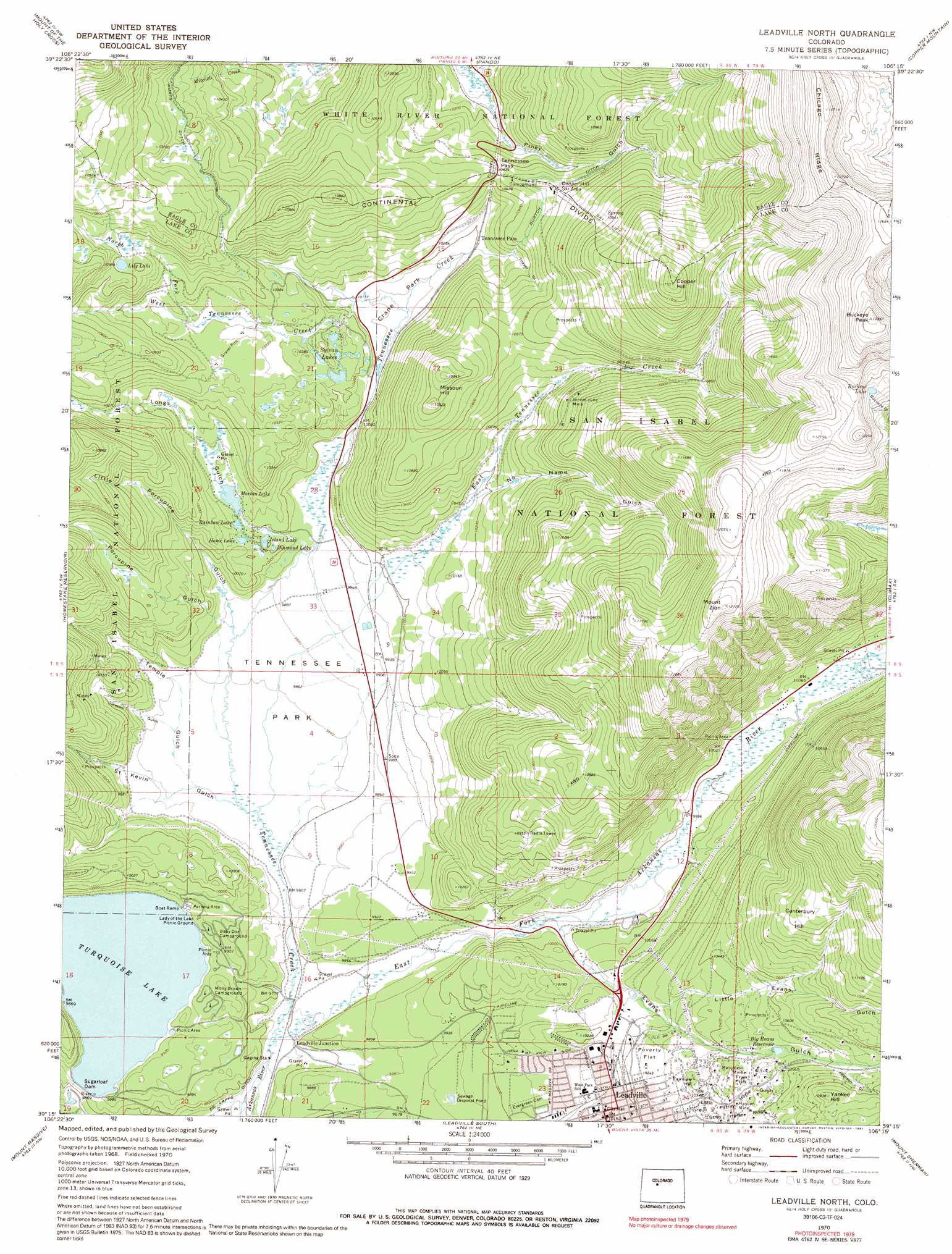
Leadville North Topo Map Colorado
To zoom in, hover over the map of Leadville North
USGS Topo Quad 39106c3 - 1:24,000 scale
| Topo Map Name: | Leadville North |
| USGS Topo Quad ID: | 39106c3 |
| Print Size: | ca. 21 1/4" wide x 27" high |
| Southeast Coordinates: | 39.25° N latitude / 106.25° W longitude |
| Map Center Coordinates: | 39.3125° N latitude / 106.3125° W longitude |
| U.S. State: | CO |
| Filename: | o39106c3.jpg |
| Download Map JPG Image: | Leadville North topo map 1:24,000 scale |
| Map Type: | Topographic |
| Topo Series: | 7.5´ |
| Map Scale: | 1:24,000 |
| Source of Map Images: | United States Geological Survey (USGS) |
| Alternate Map Versions: |
Leadville North CO 1970, updated 1973 Download PDF Buy paper map Leadville North CO 1970, updated 1973 Download PDF Buy paper map Leadville North CO 1970, updated 1991 Download PDF Buy paper map Leadville North CO 1994, updated 1998 Download PDF Buy paper map Leadville North CO 2011 Download PDF Buy paper map Leadville North CO 2013 Download PDF Buy paper map Leadville North CO 2016 Download PDF Buy paper map |
| FStopo: | US Forest Service topo Leadville North is available: Download FStopo PDF Download FStopo TIF |
1:24,000 Topo Quads surrounding Leadville North
Grouse Mountain |
Minturn |
Red Cliff |
Vail Pass |
Frisco |
Mount Jackson |
Mount Of The Holy Cross |
Pando |
Copper Mountain |
Breckenridge |
Nast |
Homestake Reservoir |
Leadville North |
Climax |
Alma |
Mount Champion |
Mount Massive |
Leadville South |
Mount Sherman |
Fairplay West |
Independence Pass |
Mount Elbert |
Granite |
South Peak |
Jones Hill |
> Back to 39106a1 at 1:100,000 scale
> Back to 39106a1 at 1:250,000 scale
> Back to U.S. Topo Maps home
Leadville North topo map: Gazetteer
Leadville North: Canals
Burton Ditch elevation 3225m 10580′Leadville North: Dams
Sugar Loaf Dam elevation 2983m 9786′Sugarloaf Dam elevation 3007m 9865′
Leadville North: Flats
Crane Park elevation 3085m 10121′Poverty Flat elevation 3126m 10255′
Tennessee Park elevation 3002m 9849′
Leadville North: Gaps
Tennessee Pass elevation 3132m 10275′Leadville North: Lakes
Buckeye Lake elevation 3631m 11912′Diamond Lake elevation 3048m 10000′
Home Lake elevation 3056m 10026′
Island Lake elevation 3048m 10000′
Lily Lake elevation 3229m 10593′
Morton Lake elevation 3067m 10062′
Rainbow Lake elevation 3056m 10026′
Sylvan Lakes elevation 3136m 10288′
Leadville North: Mines
A M Mine elevation 3110m 10203′Adams Shaft elevation 3186m 10452′
Alice Placer elevation 3161m 10370′
All Right Mine elevation 3127m 10259′
American Eagle Mine elevation 3141m 10305′
Amity Shaft elevation 3072m 10078′
Bangkok Mine elevation 3207m 10521′
Birdella Shaft elevation 3108m 10196′
Bob Ingersoll Mine elevation 3134m 10282′
Buckeye Mine elevation 3196m 10485′
Cady Mine elevation 3183m 10442′
Canterbury Hill Mine elevation 3047m 9996′
Capitol Northern Mine elevation 3122m 10242′
Chrysolite Mine elevation 3172m 10406′
Cora Belle Mine elevation 3208m 10524′
Coronado Mine elevation 3110m 10203′
Daly Mine elevation 3171m 10403′
Delante Shaft elevation 3121m 10239′
Delmonte Mine elevation 3228m 10590′
Denver City Mine elevation 3235m 10613′
Dillion Mine elevation 3149m 10331′
Elk Mine elevation 3136m 10288′
Elkhorn Shaft elevation 3352m 10997′
Fairview Hill Mine elevation 3162m 10374′
Fitzhugh Mine elevation 3210m 10531′
Fryer Hill Mine elevation 3224m 10577′
Gray Eagle Mine elevation 3136m 10288′
Greenback Mine elevation 3217m 10554′
Harvard Mine elevation 3184m 10446′
Harvard Number One Mine elevation 3204m 10511′
Hayden Mine elevation 3189m 10462′
Hazard Mine elevation 3196m 10485′
Hibernia Mine elevation 3175m 10416′
Hoffer Mine elevation 3116m 10223′
Hope Mine elevation 3141m 10305′
Huckleberry Shaft elevation 3107m 10193′
Hussy Mine elevation 3142m 10308′
Ida Nyce Shaft elevation 3170m 10400′
Jamie Lee Mine elevation 3221m 10567′
Jason Mine elevation 3131m 10272′
Jennie June Mine elevation 3252m 10669′
Jones Pit elevation 3044m 9986′
Keene Shaft elevation 3189m 10462′
Last Chip Mine elevation 3144m 10314′
Last Chip Number One Mine elevation 3146m 10321′
Last Chip Number Three Mine elevation 3146m 10321′
Last Chip Number Two Mine elevation 3161m 10370′
Little Chief Mine elevation 3189m 10462′
Little Eva Mine elevation 3168m 10393′
Little Miami Mine elevation 3227m 10587′
Little Nellie Mine elevation 3147m 10324′
Little Silver Mine elevation 3222m 10570′
Luzerne Mine elevation 3136m 10288′
Maid of Erin Mine elevation 3183m 10442′
Matchless Mine elevation 3195m 10482′
May Queen Mine elevation 3188m 10459′
May Queen Mine elevation 3226m 10583′
McCormick Mine elevation 3226m 10583′
Morning Star Mine elevation 3194m 10479′
Neptune Mine elevation 3136m 10288′
New Cambetta Mine elevation 3175m 10416′
Newell Mine elevation 3135m 10285′
Northern Shaft elevation 3125m 10252′
O K Mine elevation 3180m 10433′
Orion Mine elevation 3146m 10321′
Pandora Mine elevation 3132m 10275′
Pendry Mine elevation 3146m 10321′
Penrose Mine elevation 3120m 10236′
Pittsburgh Mine elevation 3189m 10462′
Ponsardine Shaft Mine elevation 3175m 10416′
Price Mine elevation 3217m 10554′
Quadrilateral Mine elevation 3221m 10567′
Rattling Jack Mine elevation 3208m 10524′
Reed Shaft elevation 3022m 9914′
Result Mine elevation 3221m 10567′
Robert E Lee Mine elevation 3198m 10492′
Robert Emmet Mine elevation 3204m 10511′
Sixth Street Mine elevation 3115m 10219′
Stonewall Jackson Shaft elevation 3176m 10419′
Tarshish Mine elevation 3185m 10449′
Tip Top Mine elevation 3198m 10492′
Union Mine elevation 3198m 10492′
Vanderbilt Mine elevation 3176m 10419′
Vulture Mine elevation 3173m 10410′
Waterloo Mine elevation 3237m 10620′
Webster Pit elevation 2948m 9671′
Wolcott Mine elevation 3110m 10203′
Wright Mine elevation 3219m 10561′
Leadville North: Populated Places
Leadville elevation 3097m 10160′Leadville Junction elevation 2981m 9780′
Leadville North: Reservoirs
Big Evans Reservoir elevation 3202m 10505′Turquoise Lake elevation 3007m 9865′
Leadville North: Ridges
Chicago Ridge elevation 3872m 12703′Stray Horse Ridge elevation 3187m 10456′
Leadville North: Streams
East Fork Arkansas River elevation 2965m 9727′East Tennessee Creek elevation 3000m 9842′
North Fork West Tennessee Creek elevation 3147m 10324′
Tennessee Creek elevation 2965m 9727′
West Tennessee Creek elevation 3085m 10121′
Leadville North: Summits
Buckeye Peak elevation 3923m 12870′Canterbury Hill elevation 3355m 11007′
Cooper Hill elevation 3578m 11738′
Fairview Hill elevation 3174m 10413′
Fryer Hill elevation 3199m 10495′
Loveland Mountain elevation 3260m 10695′
Missouri Hill elevation 3322m 10898′
Mount Zion elevation 3698m 12132′
Yankee Hill elevation 3335m 10941′
Leadville North: Valleys
Evans Gulch elevation 3038m 9967′Gleason Gulch elevation 3000m 9842′
Johnson Gulch elevation 3240m 10629′
Little Evans Gulch elevation 3114m 10216′
Little Porcupine Gulch elevation 3007m 9865′
Little Stray Horse Gulch elevation 3150m 10334′
Longs Gulch elevation 3038m 9967′
No Name Gulch elevation 3098m 10164′
Porcupine Gulch elevation 3005m 9858′
Saint Kevin Gulch elevation 3000m 9842′
Taylor Gulch elevation 3084m 10118′
Temple Gulch elevation 3000m 9842′
Thayer Gulch elevation 3133m 10278′
Leadville North digital topo map on disk
Buy this Leadville North topo map showing relief, roads, GPS coordinates and other geographical features, as a high-resolution digital map file on DVD: