Ruedi Topo Map Colorado
To zoom in, hover over the map of Ruedi
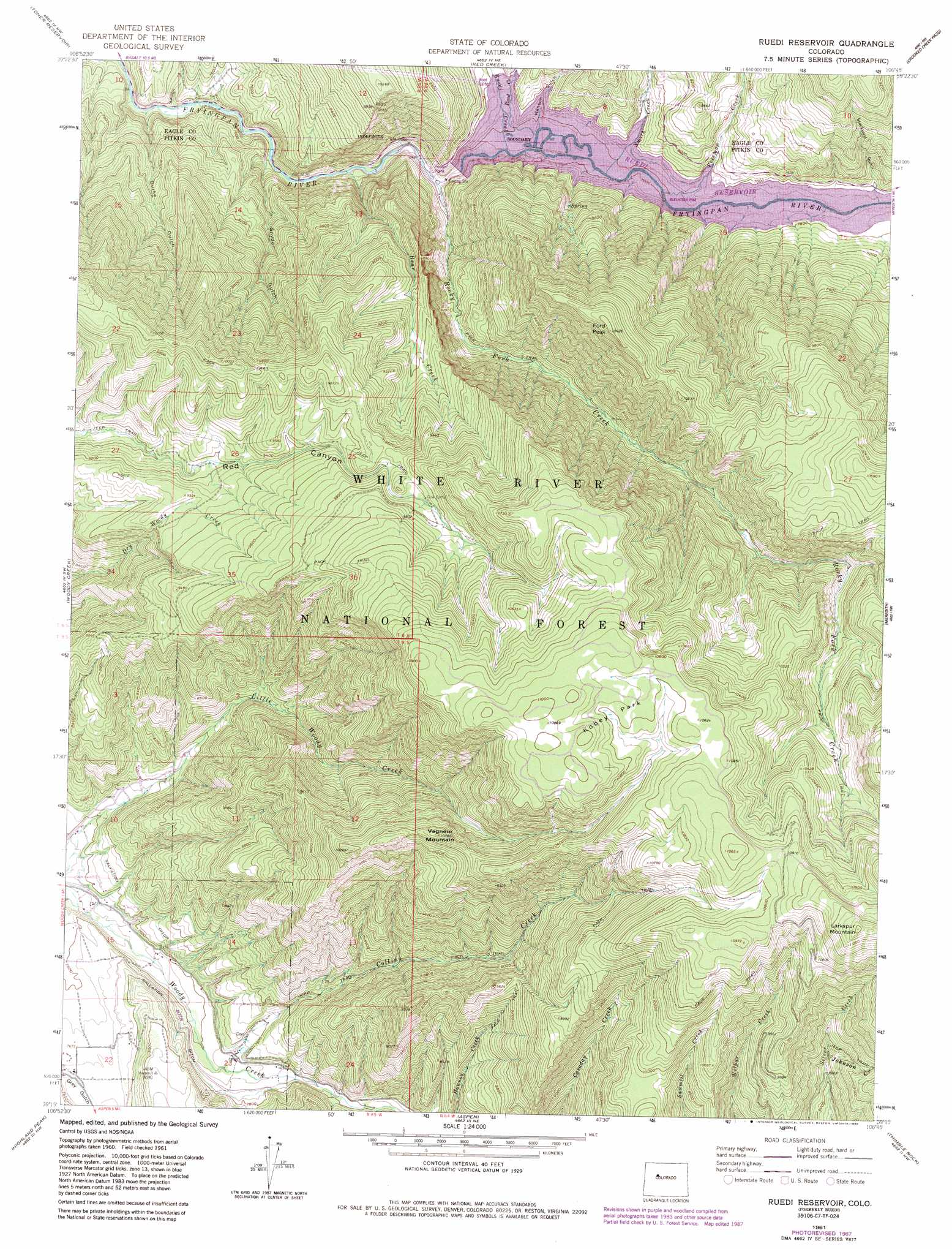
USGS Topo Quad 39106c7 - 1:24,000 scale
| Topo Map Name: | Ruedi |
| USGS Topo Quad ID: | 39106c7 |
| Print Size: | ca. 21 1/4" wide x 27" high |
| Southeast Coordinates: | 39.25° N latitude / 106.75° W longitude |
| Map Center Coordinates: | 39.3125° N latitude / 106.8125° W longitude |
| U.S. State: | CO |
| Filename: | o39106c7.jpg |
| Download Map JPG Image: | Ruedi topo map 1:24,000 scale |
| Map Type: | Topographic |
| Topo Series: | 7.5´ |
| Map Scale: | 1:24,000 |
| Source of Map Images: | United States Geological Survey (USGS) |
| Alternate Map Versions: |
Ruedi CO 1961, updated 1963 Download PDF Buy paper map Ruedi CO 1961, updated 1963 Download PDF Buy paper map Ruedi CO 1961, updated 1967 Download PDF Buy paper map Ruedi Reservoir CO 1961, updated 1983 Download PDF Buy paper map Ruedi Reservoir CO 1961, updated 1988 Download PDF Buy paper map Ruedi Reservoir CO 2011 Download PDF Buy paper map Ruedi Reservoir CO 2013 Download PDF Buy paper map Ruedi Reservoir CO 2016 Download PDF Buy paper map |
| FStopo: | US Forest Service topo Ruedi Reservoir is available: Download FStopo PDF Download FStopo TIF |
1:24,000 Topo Quads surrounding Ruedi
Cottonwood Pass |
Suicide Mountain |
The Seven Hermits |
Fulford |
Grouse Mountain |
Leon |
Toner Reservoir |
Red Creek |
Crooked Creek Pass |
Mount Jackson |
Basalt |
Woody Creek |
Ruedi |
Meredith |
Nast |
Capitol Peak |
Highland Peak |
Aspen |
Thimble Rock |
Mount Champion |
Snowmass Mountain |
Maroon Bells |
Hayden Peak |
New York Peak |
Independence Pass |
> Back to 39106a1 at 1:100,000 scale
> Back to 39106a1 at 1:250,000 scale
> Back to U.S. Topo Maps home
Ruedi topo map: Gazetteer
Ruedi: Dams
Ruedi Dam elevation 2378m 7801′Ruedi: Flats
Kobey Park elevation 3311m 10862′Ruedi: Mines
Jaffee Pit elevation 2686m 8812′Porphyry Mountain Mines Company Mine elevation 3069m 10068′
Ruedi: Populated Places
Ruedi (historical) elevation 2369m 7772′Ruedi: Streams
Bear Creek elevation 2270m 7447′Collins Creek elevation 2331m 7647′
Freeman Creek elevation 2369m 7772′
Johnson Creek elevation 2810m 9219′
Pond Creek elevation 2369m 7772′
Rocky Fork Creek elevation 2291m 7516′
Ruedi Creek elevation 2369m 7772′
Smith Creek elevation 2369m 7772′
Ruedi: Summits
Ford Peak elevation 3178m 10426′Larkspur Mountain elevation 3483m 11427′
Vagneur Mountain elevation 3160m 10367′
Ruedi: Valleys
Burke Gulch elevation 2248m 7375′Hanson Gulch elevation 2369m 7772′
Saloon Gulch elevation 2238m 7342′
Stockyard Gulch elevation 2382m 7814′
Ruedi digital topo map on disk
Buy this Ruedi topo map showing relief, roads, GPS coordinates and other geographical features, as a high-resolution digital map file on DVD: