Minturn Topo Map Colorado
To zoom in, hover over the map of Minturn
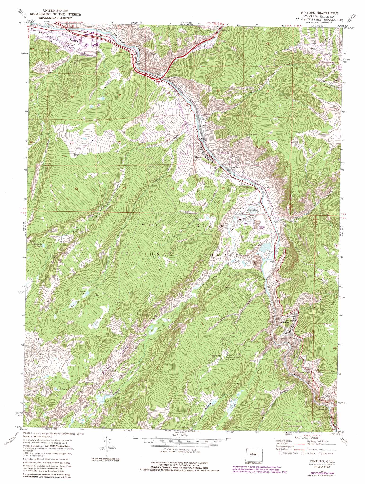
USGS Topo Quad 39106e4 - 1:24,000 scale
| Topo Map Name: | Minturn |
| USGS Topo Quad ID: | 39106e4 |
| Print Size: | ca. 21 1/4" wide x 27" high |
| Southeast Coordinates: | 39.5° N latitude / 106.375° W longitude |
| Map Center Coordinates: | 39.5625° N latitude / 106.4375° W longitude |
| U.S. State: | CO |
| Filename: | o39106e4.jpg |
| Download Map JPG Image: | Minturn topo map 1:24,000 scale |
| Map Type: | Topographic |
| Topo Series: | 7.5´ |
| Map Scale: | 1:24,000 |
| Source of Map Images: | United States Geological Survey (USGS) |
| Alternate Map Versions: |
Minturn CO 1970, updated 1973 Download PDF Buy paper map Minturn CO 1970, updated 1973 Download PDF Buy paper map Minturn CO 1970, updated 1982 Download PDF Buy paper map Minturn CO 1970, updated 1988 Download PDF Buy paper map Minturn CO 1970, updated 1988 Download PDF Buy paper map Minturn CO 2011 Download PDF Buy paper map Minturn CO 2013 Download PDF Buy paper map Minturn CO 2016 Download PDF Buy paper map |
| FStopo: | US Forest Service topo Minturn is available: Download FStopo PDF Download FStopo TIF |
1:24,000 Topo Quads surrounding Minturn
State Bridge |
Lava Creek |
Piney Peak |
Mount Powell |
Squaw Creek |
Wolcott |
Edwards |
Vail West |
Vail East |
Willow Lakes |
Fulford |
Grouse Mountain |
Minturn |
Red Cliff |
Vail Pass |
Crooked Creek Pass |
Mount Jackson |
Mount Of The Holy Cross |
Pando |
Copper Mountain |
Meredith |
Nast |
Homestake Reservoir |
Leadville North |
Climax |
> Back to 39106e1 at 1:100,000 scale
> Back to 39106a1 at 1:250,000 scale
> Back to U.S. Topo Maps home
Minturn topo map: Gazetteer
Minturn: Airports
Vail Junction Heliport elevation 3163m 10377′Minturn: Basins
Game Creek Bowl elevation 3004m 9855′Minturn: Canals
Bolts Ditch elevation 2499m 8198′Fleck Ditch elevation 2305m 7562′
Minturn: Dams
Bolts Lake Dam elevation 2473m 8113′Minturn: Flats
Maloit Park elevation 2447m 8028′Minturn: Lakes
Buffalo Lake elevation 3328m 10918′Grouse Lake elevation 3265m 10711′
Waterdog Lake elevation 3291m 10797′
Minturn: Mines
Ben Butler Mine elevation 2576m 8451′Eagle Mine elevation 2657m 8717′
Homestake Creek Mine elevation 2893m 9491′
Little Spring Mine elevation 2632m 8635′
New Jersey Zinc Pit elevation 2652m 8700′
Newhouse Tunnel elevation 2589m 8494′
Pine Marten Mine elevation 2708m 8884′
Pine Marten Mine elevation 2681m 8795′
Red Cliff District Mine elevation 2725m 8940′
Tip Top Mine elevation 2728m 8950′
Minturn: Populated Places
Astor City (historical) elevation 2489m 8166′Belden elevation 2940m 9645′
Dowds Junction elevation 2353m 7719′
Eagles Nest elevation 3148m 10328′
Gilman elevation 2728m 8950′
Minturn elevation 2396m 7860′
Minturn: Post Offices
Tigiwon Post Office (historical) elevation 3031m 9944′Minturn: Reservoirs
Bolts Lake elevation 2473m 8113′Minturn: Streams
Cross Creek elevation 2433m 7982′Fall Creek elevation 2543m 8343′
Game Creek elevation 2380m 7808′
Girard Creek elevation 2662m 8733′
Gore Creek elevation 2351m 7713′
Grouse Creek elevation 2381m 7811′
Homestake Creek elevation 2617m 8585′
Martin Creek elevation 2397m 7864′
Notch Mountain Creek elevation 2889m 9478′
Peterson Creek elevation 2586m 8484′
Rock Creek elevation 2524m 8280′
Stone Creek elevation 2301m 7549′
Traer Creek elevation 2316m 7598′
Turkey Creek elevation 2618m 8589′
Two Elk Creek elevation 2443m 8015′
West Grouse Creek elevation 2488m 8162′
Whiskey Creek elevation 2338m 7670′
Minturn: Summits
Lionshead elevation 3024m 9921′Minturn: Valleys
Bishop Gulch elevation 2499m 8198′Minturn digital topo map on disk
Buy this Minturn topo map showing relief, roads, GPS coordinates and other geographical features, as a high-resolution digital map file on DVD: