Fulford Topo Map Colorado
To zoom in, hover over the map of Fulford
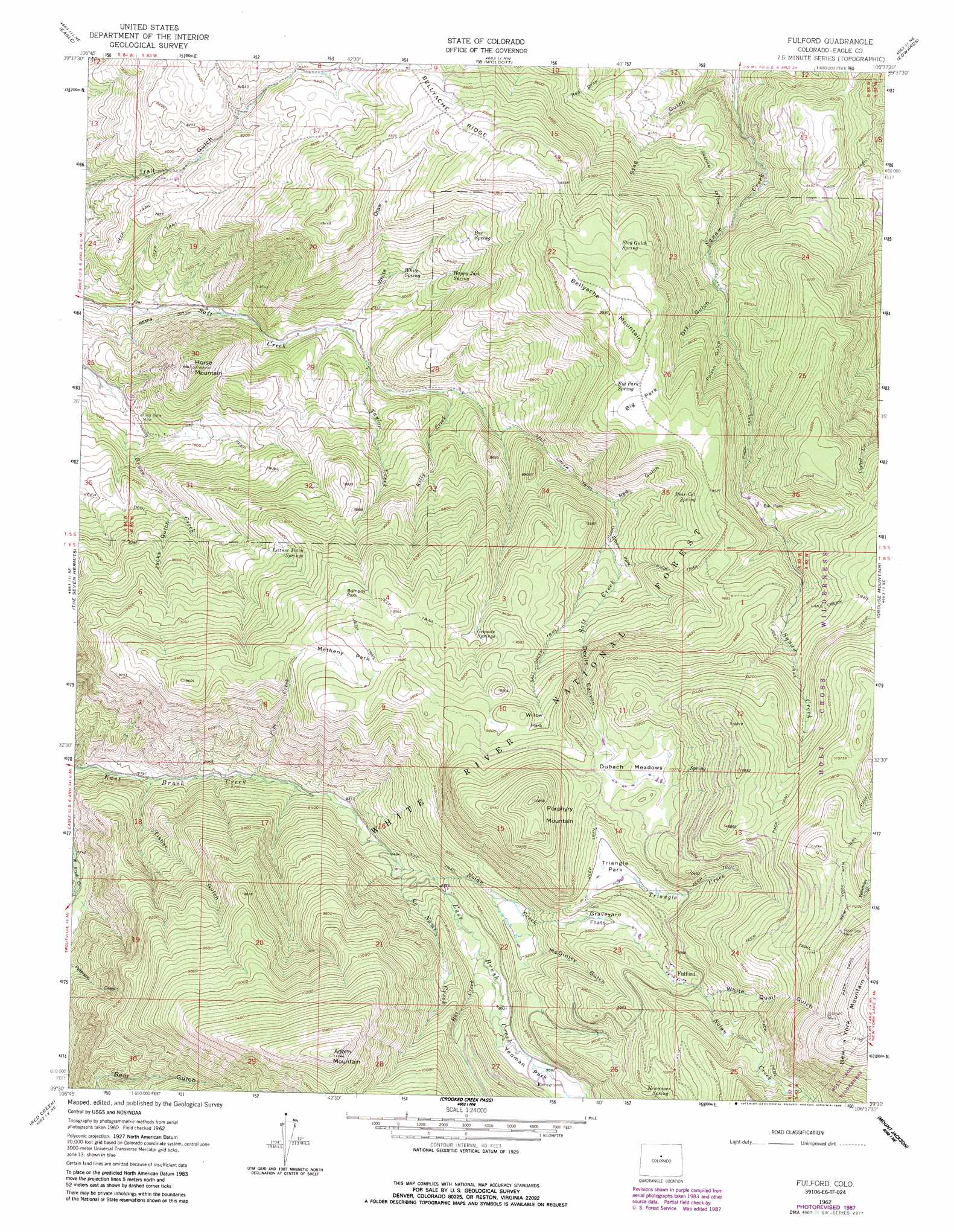
USGS Topo Quad 39106e6 - 1:24,000 scale
| Topo Map Name: | Fulford |
| USGS Topo Quad ID: | 39106e6 |
| Print Size: | ca. 21 1/4" wide x 27" high |
| Southeast Coordinates: | 39.5° N latitude / 106.625° W longitude |
| Map Center Coordinates: | 39.5625° N latitude / 106.6875° W longitude |
| U.S. State: | CO |
| Filename: | o39106e6.jpg |
| Download Map JPG Image: | Fulford topo map 1:24,000 scale |
| Map Type: | Topographic |
| Topo Series: | 7.5´ |
| Map Scale: | 1:24,000 |
| Source of Map Images: | United States Geological Survey (USGS) |
| Alternate Map Versions: |
Fulford CO 1962, updated 1964 Download PDF Buy paper map Fulford CO 1962, updated 1964 Download PDF Buy paper map Fulford CO 1962, updated 1970 Download PDF Buy paper map Fulford CO 1962, updated 1987 Download PDF Buy paper map Fulford CO 2011 Download PDF Buy paper map Fulford CO 2013 Download PDF Buy paper map Fulford CO 2016 Download PDF Buy paper map |
| FStopo: | US Forest Service topo Fulford is available: Download FStopo PDF Download FStopo TIF |
1:24,000 Topo Quads surrounding Fulford
Burns South |
Castle Peak |
State Bridge |
Lava Creek |
Piney Peak |
Gypsum |
Eagle |
Wolcott |
Edwards |
Vail West |
Suicide Mountain |
The Seven Hermits |
Fulford |
Grouse Mountain |
Minturn |
Toner Reservoir |
Red Creek |
Crooked Creek Pass |
Mount Jackson |
Mount Of The Holy Cross |
Woody Creek |
Ruedi |
Meredith |
Nast |
Homestake Reservoir |
> Back to 39106e1 at 1:100,000 scale
> Back to 39106a1 at 1:250,000 scale
> Back to U.S. Topo Maps home
Fulford topo map: Gazetteer
Fulford: Canals
Bemis Ditch elevation 2274m 7460′Graham Ditch elevation 2542m 8339′
Fulford: Flats
Big Park elevation 2903m 9524′Bumpity Park elevation 2882m 9455′
Dubach Meadows elevation 3074m 10085′
Elbow Park elevation 2699m 8854′
Elk Park elevation 2823m 9261′
Graveyard Flats elevation 2921m 9583′
Metheny Park elevation 2919m 9576′
Triangle Park elevation 2984m 9790′
Willow Park elevation 2974m 9757′
Yeoman Park elevation 2763m 9064′
Fulford: Mines
At Last Mine elevation 3203m 10508′Johnson Mine elevation 3562m 11686′
Lady Belle Mine elevation 2335m 7660′
North Dakota Mine elevation 2389m 7837′
Polar Star Mine elevation 3432m 11259′
Fulford: Populated Places
Fulford elevation 2999m 9839′Fulford: Reservoirs
Triangle Reservoir elevation 2985m 9793′Fulford: Springs
Bear Cat Spring elevation 2885m 9465′Big Park Spring elevation 2880m 9448′
Box Spring elevation 2633m 8638′
Granite Springs elevation 2852m 9356′
Happy Jack Spring elevation 2527m 8290′
Lettuce Patch Springs elevation 2776m 9107′
Newcomer Spring elevation 3110m 10203′
Stag Gulch Spring elevation 2887m 9471′
White Spring elevation 2470m 8103′
Fulford: Streams
Hat Creek elevation 2705m 8874′Kelly Creek elevation 2437m 7995′
No Name Creek elevation 2611m 8566′
Nolan Creek elevation 2657m 8717′
Pipe Creek elevation 2452m 8044′
Salt Creek elevation 2575m 8448′
Taylor Creek elevation 2388m 7834′
Triangle Creek elevation 2811m 9222′
Fulford: Summits
Adam Mountain elevation 3391m 11125′Bellyache Mountain elevation 2936m 9632′
Horse Mountain elevation 2629m 8625′
Porphyry Mountain elevation 3302m 10833′
Whittaker Point elevation 2767m 9078′
Fulford: Trails
Lake Creek Trail elevation 3008m 9868′New York Mountain Trail elevation 3333m 10935′
Salt Creek Trail elevation 2694m 8838′
Fulford: Valleys
Devils Canyon elevation 2816m 9238′Dry Gulch elevation 2565m 8415′
Fisher Gulch elevation 2388m 7834′
Jacks Gulch elevation 2452m 8044′
McGinley Gulch elevation 2814m 9232′
Poison Gulch elevation 2595m 8513′
Red Gulch elevation 2655m 8710′
Stag Gulch elevation 2324m 7624′
White Draw elevation 2378m 7801′
White Quail Gulch elevation 3047m 9996′
Fulford digital topo map on disk
Buy this Fulford topo map showing relief, roads, GPS coordinates and other geographical features, as a high-resolution digital map file on DVD: