Eagle Topo Map Colorado
To zoom in, hover over the map of Eagle
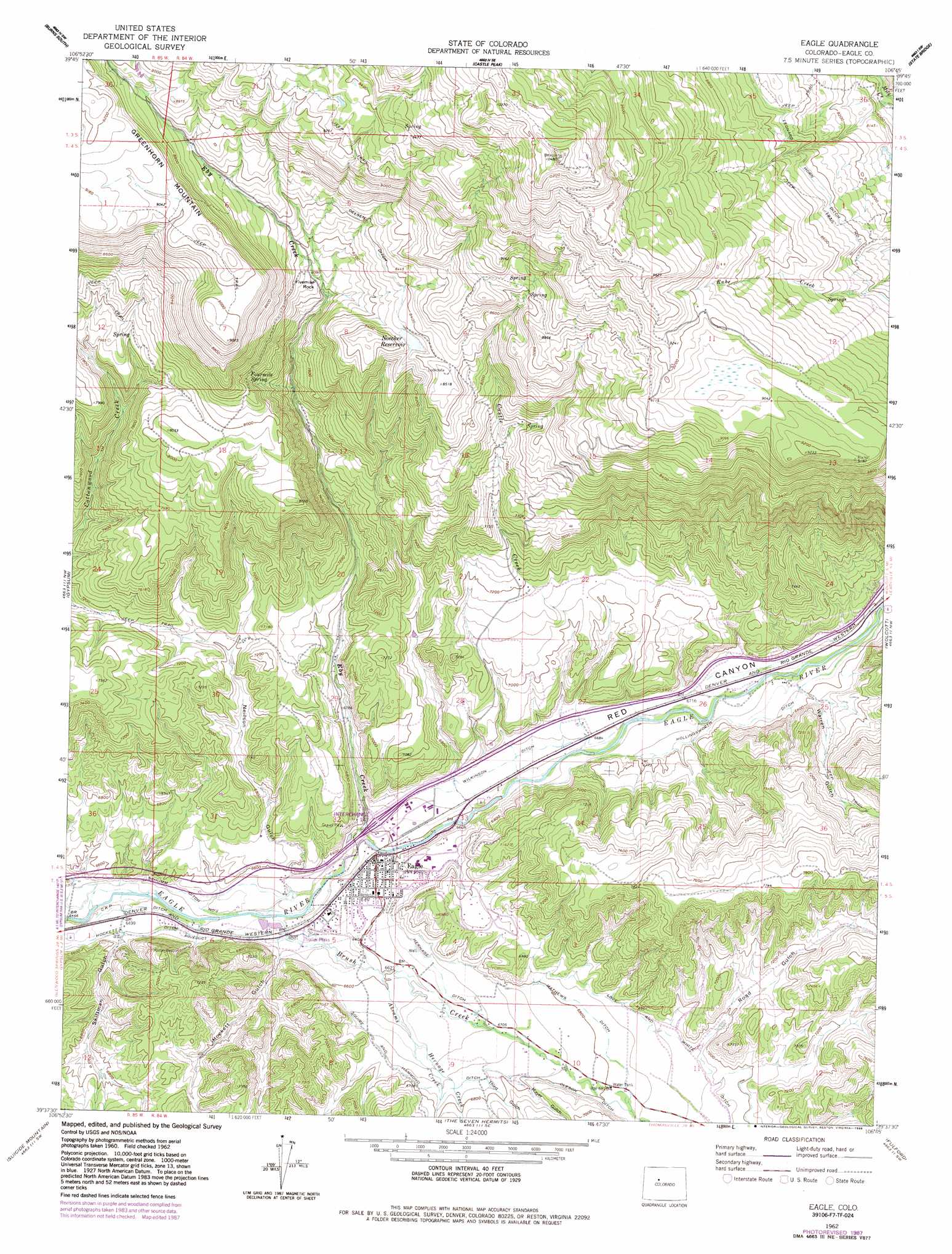
USGS Topo Quad 39106f7 - 1:24,000 scale
| Topo Map Name: | Eagle |
| USGS Topo Quad ID: | 39106f7 |
| Print Size: | ca. 21 1/4" wide x 27" high |
| Southeast Coordinates: | 39.625° N latitude / 106.75° W longitude |
| Map Center Coordinates: | 39.6875° N latitude / 106.8125° W longitude |
| U.S. State: | CO |
| Filename: | o39106f7.jpg |
| Download Map JPG Image: | Eagle topo map 1:24,000 scale |
| Map Type: | Topographic |
| Topo Series: | 7.5´ |
| Map Scale: | 1:24,000 |
| Source of Map Images: | United States Geological Survey (USGS) |
| Alternate Map Versions: |
Eagle CO 1962, updated 1964 Download PDF Buy paper map Eagle CO 1962, updated 1969 Download PDF Buy paper map Eagle CO 1962, updated 1983 Download PDF Buy paper map Eagle CO 1962, updated 1988 Download PDF Buy paper map Eagle CO 2010 Download PDF Buy paper map Eagle CO 2013 Download PDF Buy paper map Eagle CO 2016 Download PDF Buy paper map |
1:24,000 Topo Quads surrounding Eagle
Dome Peak |
Burns North |
Blue Hill |
Mccoy |
Radium |
Sugarloaf Mountain |
Burns South |
Castle Peak |
State Bridge |
Lava Creek |
Dotsero |
Gypsum |
Eagle |
Wolcott |
Edwards |
Cottonwood Pass |
Suicide Mountain |
The Seven Hermits |
Fulford |
Grouse Mountain |
Leon |
Toner Reservoir |
Red Creek |
Crooked Creek Pass |
Mount Jackson |
> Back to 39106e1 at 1:100,000 scale
> Back to 39106a1 at 1:250,000 scale
> Back to U.S. Topo Maps home
Eagle topo map: Gazetteer
Eagle: Airports
Castle Peak Heliport elevation 2566m 8418′Eagle: Canals
Hockett Ditch elevation 1988m 6522′Hollingsworth Ditch elevation 2059m 6755′
Love and White Ditch elevation 2117m 6945′
Mathews Ditch elevation 2076m 6811′
Oelsen Ditch elevation 2558m 8392′
Oleson Ditch elevation 2089m 6853′
Schumm Ditch Number 1 elevation 1985m 6512′
Warren Ditch elevation 2049m 6722′
Wilkinson Ditch elevation 2033m 6669′
Eagle: Dams
Noecker Dam elevation 2536m 8320′Eagle: Mines
Eagle Mine elevation 2048m 6719′Eagle: Pillars
Fivemile Rock elevation 2459m 8067′Eagle: Populated Places
Eagle elevation 2012m 6601′Eagle: Reservoirs
Noecker Reservoir elevation 2536m 8320′Eagle: Springs
Fourmile Spring elevation 2448m 8031′Eagle: Streams
Abrams Creek elevation 2013m 6604′Castle Creek elevation 2023m 6637′
Eby Creek elevation 2001m 6564′
Hernage Creek elevation 2028m 6653′
Eagle: Valleys
Hockett Gulch elevation 1997m 6551′Mayer Gulch elevation 2062m 6765′
Neilson Gucch elevation 2005m 6578′
Red Canyon elevation 2009m 6591′
Road Gulch elevation 2110m 6922′
Skillman Gulch elevation 1987m 6519′
Third Gulch elevation 2060m 6758′
Warren Gulch elevation 2069m 6788′
Eagle digital topo map on disk
Buy this Eagle topo map showing relief, roads, GPS coordinates and other geographical features, as a high-resolution digital map file on DVD: