Battle Mountain Topo Map Colorado
To zoom in, hover over the map of Battle Mountain
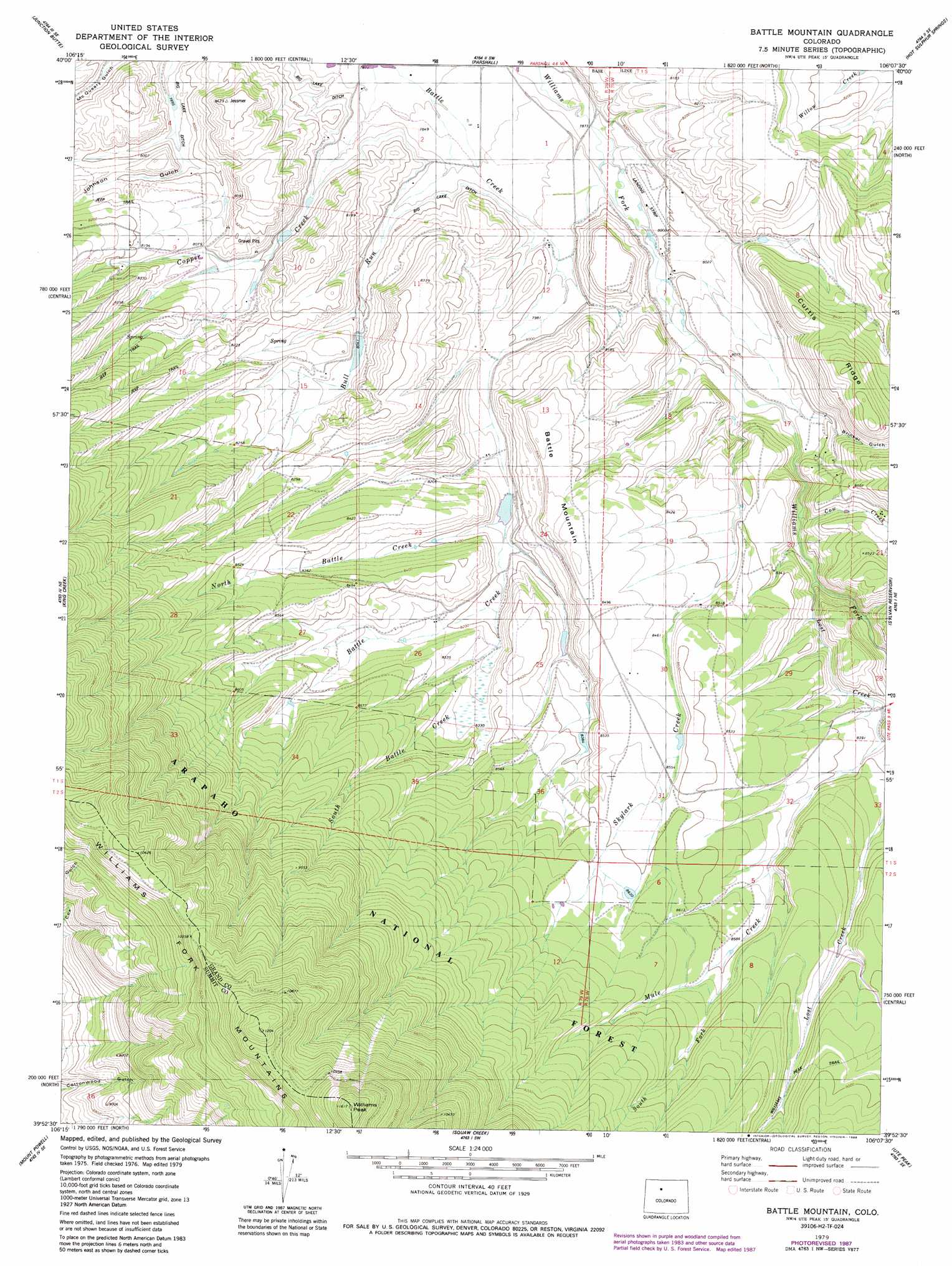
USGS Topo Quad 39106h2 - 1:24,000 scale
| Topo Map Name: | Battle Mountain |
| USGS Topo Quad ID: | 39106h2 |
| Print Size: | ca. 21 1/4" wide x 27" high |
| Southeast Coordinates: | 39.875° N latitude / 106.125° W longitude |
| Map Center Coordinates: | 39.9375° N latitude / 106.1875° W longitude |
| U.S. State: | CO |
| Filename: | o39106h2.jpg |
| Download Map JPG Image: | Battle Mountain topo map 1:24,000 scale |
| Map Type: | Topographic |
| Topo Series: | 7.5´ |
| Map Scale: | 1:24,000 |
| Source of Map Images: | United States Geological Survey (USGS) |
| Alternate Map Versions: |
Battle Mountain CO 1979, updated 1979 Download PDF Buy paper map Battle Mountain CO 1979, updated 1988 Download PDF Buy paper map Battle Mountain CO 2011 Download PDF Buy paper map Battle Mountain CO 2013 Download PDF Buy paper map Battle Mountain CO 2016 Download PDF Buy paper map |
| FStopo: | US Forest Service topo Battle Mountain is available: Download FStopo PDF Download FStopo TIF |
1:24,000 Topo Quads surrounding Battle Mountain
Hinman Reservoir |
Gunsight Pass |
Corral Peaks |
Cabin Creek |
Trail Mountain |
Kremmling |
Junction Butte |
Parshall |
Hot Sulpher Springs |
Granby |
Sheephorn Mountain |
King Creek |
Battle Mountain |
Sylvan Reservoir |
Bottle Pass |
Piney Peak |
Mount Powell |
Squaw Creek |
Ute Peak |
Byers Peak |
Vail West |
Vail East |
Willow Lakes |
Dillon |
Loveland Pass |
> Back to 39106e1 at 1:100,000 scale
> Back to 39106a1 at 1:250,000 scale
> Back to U.S. Topo Maps home
Battle Mountain topo map: Gazetteer
Battle Mountain: Dams
Cole Dam elevation 2528m 8293′Dale Dam elevation 2561m 8402′
Langholen Dam elevation 2473m 8113′
Battle Mountain: Reservoirs
Cole Reservoir elevation 2528m 8293′Dale Reservoir elevation 2561m 8402′
Langholen Reservoir elevation 2473m 8113′
Battle Mountain: Ridges
Curtis Ridge elevation 2637m 8651′Battle Mountain: Streams
Bull Run elevation 2386m 7828′Cow Creek elevation 2467m 8093′
Lost Creek elevation 2483m 8146′
Mule Creek elevation 2630m 8628′
North Battle Creek elevation 2473m 8113′
Skylark Creek elevation 2443m 8015′
South Battle Creek elevation 2493m 8179′
South Fork Mule Creek elevation 2620m 8595′
Battle Mountain: Summits
Battle Mountain elevation 2603m 8540′Williams Peak elevation 3530m 11581′
Battle Mountain: Trails
Williams Peak Trail elevation 2675m 8776′Battle Mountain: Valleys
Brinker Gulch elevation 2517m 8257′Battle Mountain digital topo map on disk
Buy this Battle Mountain topo map showing relief, roads, GPS coordinates and other geographical features, as a high-resolution digital map file on DVD: