Collbran Topo Map Colorado
To zoom in, hover over the map of Collbran
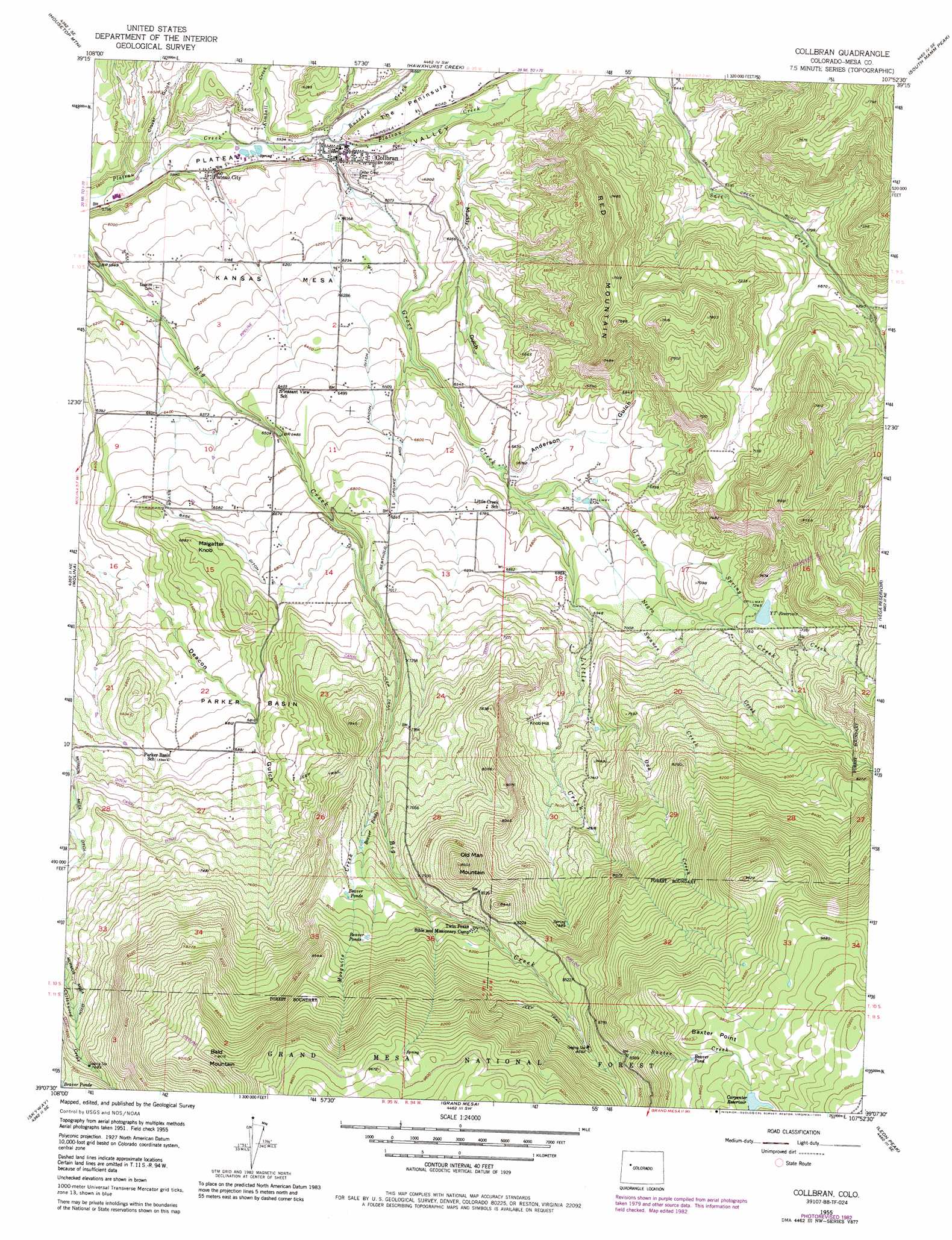
USGS Topo Quad 39107b8 - 1:24,000 scale
| Topo Map Name: | Collbran |
| USGS Topo Quad ID: | 39107b8 |
| Print Size: | ca. 21 1/4" wide x 27" high |
| Southeast Coordinates: | 39.125° N latitude / 107.875° W longitude |
| Map Center Coordinates: | 39.1875° N latitude / 107.9375° W longitude |
| U.S. State: | CO |
| Filename: | o39107b8.jpg |
| Download Map JPG Image: | Collbran topo map 1:24,000 scale |
| Map Type: | Topographic |
| Topo Series: | 7.5´ |
| Map Scale: | 1:24,000 |
| Source of Map Images: | United States Geological Survey (USGS) |
| Alternate Map Versions: |
Collbran CO 1955, updated 1957 Download PDF Buy paper map Collbran CO 1955, updated 1957 Download PDF Buy paper map Collbran CO 1955, updated 1965 Download PDF Buy paper map Collbran CO 1955, updated 1965 Download PDF Buy paper map Collbran CO 1955, updated 1984 Download PDF Buy paper map Collbran CO 2011 Download PDF Buy paper map Collbran CO 2013 Download PDF Buy paper map Collbran CO 2016 Download PDF Buy paper map |
| FStopo: | US Forest Service topo Collbran is available: Download FStopo PDF Download FStopo TIF |
1:24,000 Topo Quads surrounding Collbran
Red Pinnacle |
Parachute |
Rulison |
North Mamm Peak |
Hunter Mesa |
De Beque |
Housetop Mountain |
Hawxhurst Creek |
South Mamm Peak |
Hightower Mountain |
Mesa |
Molina |
Collbran |
The Meadows |
Porter Mountain |
Lands End |
Mesa Lakes |
Grand Mesa |
Leon Peak |
Chalk Mountain |
Indian Point |
Hells Kitchen |
Cedaredge |
Dry Creek |
Gray Reservoir |
> Back to 39107a1 at 1:100,000 scale
> Back to 39106a1 at 1:250,000 scale
> Back to U.S. Topo Maps home
Collbran topo map: Gazetteer
Collbran: Basins
Parker Basin elevation 2071m 6794′Collbran: Canals
Berthold Updyke and Landon Ditch elevation 1986m 6515′Silver Gage Ditch elevation 2038m 6686′
Collbran: Cliffs
Baxter Point elevation 3002m 9849′Collbran: Dams
Carpenter Dam elevation 3032m 9947′Y T Dam elevation 2206m 7237′
Collbran: Populated Places
Collbran elevation 1824m 5984′Plateau City elevation 1817m 5961′
Collbran: Reservoirs
Carpenter Reservoir elevation 3032m 9947′Y T Reservoir elevation 2206m 7237′
YT Reservoir elevation 2210m 7250′
Collbran: Slopes
Knob Hill elevation 2245m 7365′Collbran: Streams
Baxter Creek elevation 2645m 8677′Buzzard Creek elevation 1817m 5961′
Grove Creek elevation 1814m 5951′
Kimball Creek elevation 1801m 5908′
Little Creek elevation 2020m 6627′
Mosquito Creek elevation 2278m 7473′
Negro Creek elevation 2055m 6742′
Oak Creek elevation 2168m 7112′
Pretty Creek elevation 2677m 8782′
Spring Creek elevation 2095m 6873′
Swanee Creek elevation 2098m 6883′
Collbran: Summits
Bald Mountain elevation 2795m 9169′Kansas Mesa elevation 1917m 6289′
Maigatter Knob elevation 2089m 6853′
Old Man Mountain elevation 2624m 8608′
Red Mountain elevation 2369m 7772′
Sugarloaf Peak elevation 2249m 7378′
Collbran: Valleys
Anderson Gulch elevation 2009m 6591′Clover Gulch elevation 1779m 5836′
Death Valley elevation 2677m 8782′
Muddy Gulch elevation 1840m 6036′
Collbran digital topo map on disk
Buy this Collbran topo map showing relief, roads, GPS coordinates and other geographical features, as a high-resolution digital map file on DVD: