Leon Topo Map Colorado
To zoom in, hover over the map of Leon
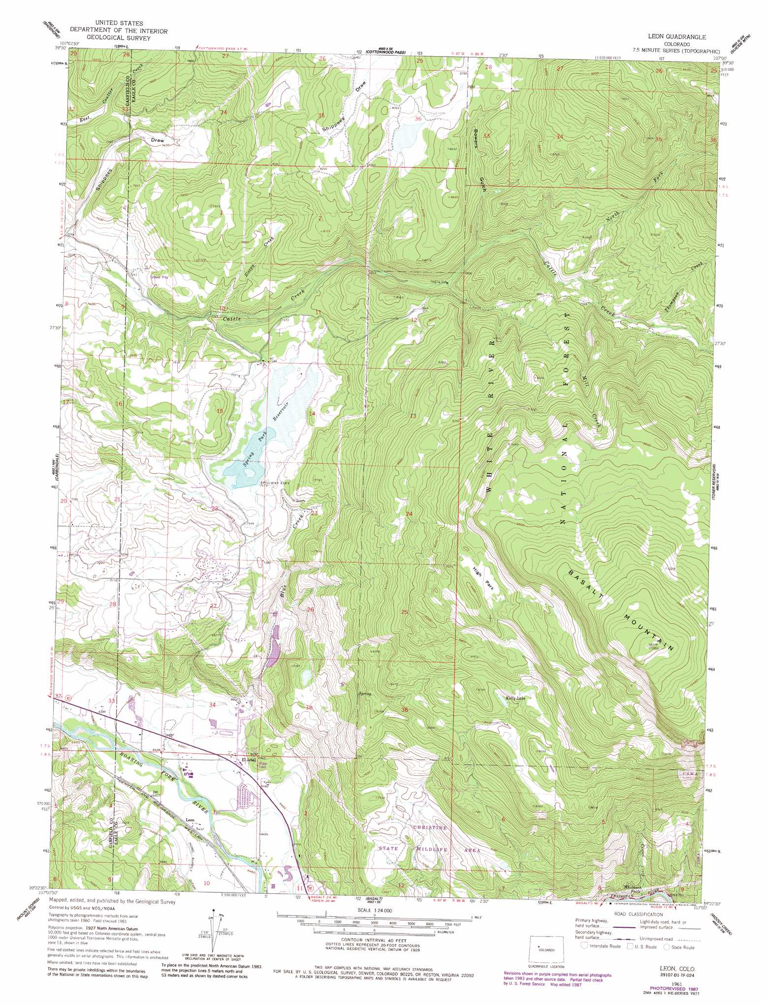
USGS Topo Quad 39107d1 - 1:24,000 scale
| Topo Map Name: | Leon |
| USGS Topo Quad ID: | 39107d1 |
| Print Size: | ca. 21 1/4" wide x 27" high |
| Southeast Coordinates: | 39.375° N latitude / 107° W longitude |
| Map Center Coordinates: | 39.4375° N latitude / 107.0625° W longitude |
| U.S. State: | CO |
| Filename: | o39107d1.jpg |
| Download Map JPG Image: | Leon topo map 1:24,000 scale |
| Map Type: | Topographic |
| Topo Series: | 7.5´ |
| Map Scale: | 1:24,000 |
| Source of Map Images: | United States Geological Survey (USGS) |
| Alternate Map Versions: |
Leon CO 1961, updated 1963 Download PDF Buy paper map Leon CO 1961, updated 1966 Download PDF Buy paper map Leon CO 1961, updated 1984 Download PDF Buy paper map Leon CO 1961, updated 1988 Download PDF Buy paper map Leon CO 2011 Download PDF Buy paper map Leon CO 2013 Download PDF Buy paper map Leon CO 2016 Download PDF Buy paper map |
| FStopo: | US Forest Service topo Leon is available: Download FStopo PDF Download FStopo TIF |
1:24,000 Topo Quads surrounding Leon
Carbonate |
Broken Rib Creek |
Dotsero |
Gypsum |
Eagle |
Glenwood Springs |
Shoshone |
Cottonwood Pass |
Suicide Mountain |
The Seven Hermits |
Cattle Creek |
Carbondale |
Leon |
Toner Reservoir |
Red Creek |
Stony Ridge |
Mount Sopris |
Basalt |
Woody Creek |
Ruedi |
Placita |
Redstone |
Capitol Peak |
Highland Peak |
Aspen |
> Back to 39107a1 at 1:100,000 scale
> Back to 39106a1 at 1:250,000 scale
> Back to U.S. Topo Maps home
Leon topo map: Gazetteer
Leon: Dams
Kelly Pond Dam elevation 2600m 8530′McNulty Dam elevation 2438m 7998′
Spring Park Dam elevation 2277m 7470′
Leon: Falls
Whitnach Falls elevation 2071m 6794′Leon: Flats
High Park elevation 2831m 9288′Leon: Lakes
Kelly Lake elevation 2608m 8556′Leon: Populated Places
El Jebel elevation 1976m 6482′Leon elevation 1964m 6443′
Leon: Reservoirs
Kelly Pond Reservoir elevation 2600m 8530′McNulty Reservoir elevation 2438m 7998′
Spring Park Reservoir elevation 2277m 7470′
Leon: Streams
Blue Creek elevation 1952m 6404′Center Creek elevation 2056m 6745′
Mill Creek elevation 2417m 7929′
North Fork Cattle Creek elevation 2401m 7877′
Sleepy Creek elevation 2259m 7411′
Thompson Creek elevation 2443m 8015′
Leon: Summits
Basalt Mountain elevation 3310m 10859′Leon: Trails
Blue Creek Trail elevation 2648m 8687′Leon: Valleys
Bowers Gulch elevation 2354m 7723′Shippees Draw elevation 2198m 7211′
Leon digital topo map on disk
Buy this Leon topo map showing relief, roads, GPS coordinates and other geographical features, as a high-resolution digital map file on DVD: