Center Mountain Topo Map Colorado
To zoom in, hover over the map of Center Mountain
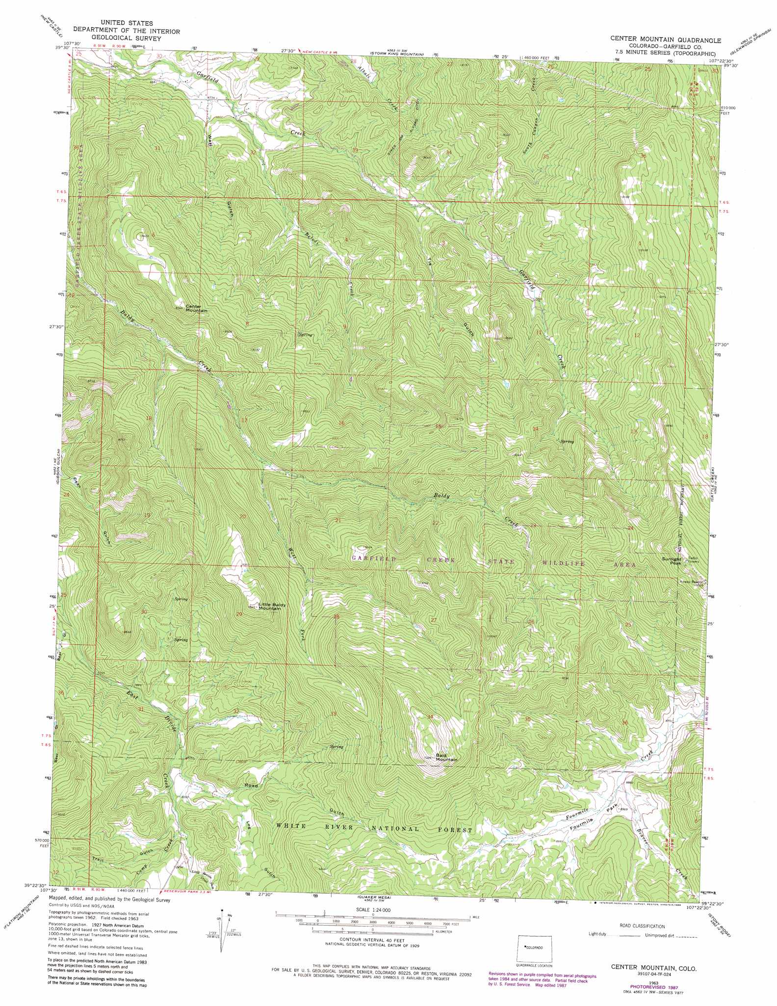
USGS Topo Quad 39107d4 - 1:24,000 scale
| Topo Map Name: | Center Mountain |
| USGS Topo Quad ID: | 39107d4 |
| Print Size: | ca. 21 1/4" wide x 27" high |
| Southeast Coordinates: | 39.375° N latitude / 107.375° W longitude |
| Map Center Coordinates: | 39.4375° N latitude / 107.4375° W longitude |
| U.S. State: | CO |
| Filename: | o39107d4.jpg |
| Download Map JPG Image: | Center Mountain topo map 1:24,000 scale |
| Map Type: | Topographic |
| Topo Series: | 7.5´ |
| Map Scale: | 1:24,000 |
| Source of Map Images: | United States Geological Survey (USGS) |
| Alternate Map Versions: |
Center Mountain CO 1963, updated 1967 Download PDF Buy paper map Center Mountain CO 1963, updated 1967 Download PDF Buy paper map Center Mountain CO 1963, updated 1984 Download PDF Buy paper map Center Mountain CO 1963, updated 1984 Download PDF Buy paper map Center Mountain CO 1963, updated 1988 Download PDF Buy paper map Center Mountain CO 2011 Download PDF Buy paper map Center Mountain CO 2013 Download PDF Buy paper map Center Mountain CO 2016 Download PDF Buy paper map |
| FStopo: | US Forest Service topo Center Mountain is available: Download FStopo PDF Download FStopo TIF |
1:24,000 Topo Quads surrounding Center Mountain
Rifle Falls |
Deep Creek Point |
Adams Lake |
Carbonate |
Broken Rib Creek |
Silt |
New Castle |
Storm King Mountain |
Glenwood Springs |
Shoshone |
Hunter Mesa |
Gibson Gulch |
Center Mountain |
Cattle Creek |
Carbondale |
Hightower Mountain |
Flatiron Mountain |
Quaker Mesa |
Stony Ridge |
Mount Sopris |
Porter Mountain |
Spruce Mountain |
Elk Knob |
Placita |
Redstone |
> Back to 39107a1 at 1:100,000 scale
> Back to 39106a1 at 1:250,000 scale
> Back to U.S. Topo Maps home
Center Mountain topo map: Gazetteer
Center Mountain: Airports
Sunlite Heliport elevation 3050m 10006′Center Mountain: Flats
Fourmile Park elevation 2734m 8969′Center Mountain: Streams
Beaver Creek elevation 2705m 8874′Belodi Creek elevation 2061m 6761′
Camp Creek elevation 2476m 8123′
Little Beaver Dam Creek elevation 2502m 8208′
West Fork Baldy Creek elevation 2475m 8120′
Center Mountain: Summits
Bald Mountain elevation 3162m 10374′Center Mountain elevation 2602m 8536′
Little Baldy Mountain elevation 2932m 9619′
Sunlight Peak elevation 3223m 10574′
Center Mountain: Valleys
Log Gulch elevation 2513m 8244′Road Gulch elevation 2440m 8005′
Sykes and Alford Ditch elevation 2200m 7217′
Tie Gulch elevation 2251m 7385′
Trail Gulch elevation 2504m 8215′
V Gulch elevation 2037m 6683′
Center Mountain digital topo map on disk
Buy this Center Mountain topo map showing relief, roads, GPS coordinates and other geographical features, as a high-resolution digital map file on DVD: