Rifle Falls Topo Map Colorado
To zoom in, hover over the map of Rifle Falls
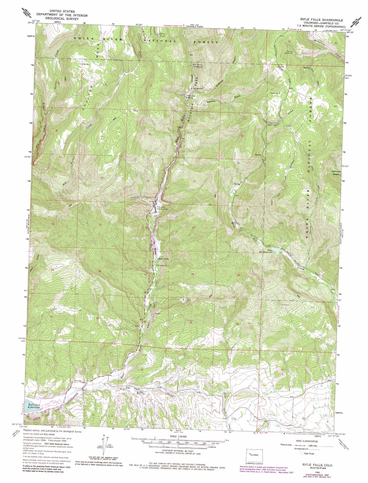
USGS Topo Quad 39107f6 - 1:24,000 scale
| Topo Map Name: | Rifle Falls |
| USGS Topo Quad ID: | 39107f6 |
| Print Size: | ca. 21 1/4" wide x 27" high |
| Southeast Coordinates: | 39.625° N latitude / 107.625° W longitude |
| Map Center Coordinates: | 39.6875° N latitude / 107.6875° W longitude |
| U.S. State: | CO |
| Filename: | o39107f6.jpg |
| Download Map JPG Image: | Rifle Falls topo map 1:24,000 scale |
| Map Type: | Topographic |
| Topo Series: | 7.5´ |
| Map Scale: | 1:24,000 |
| Source of Map Images: | United States Geological Survey (USGS) |
| Alternate Map Versions: |
Rifle Falls CO 1966, updated 1969 Download PDF Buy paper map Rifle Falls CO 1966, updated 1969 Download PDF Buy paper map Rifle Falls CO 1966, updated 1984 Download PDF Buy paper map Rifle Falls CO 1966, updated 1984 Download PDF Buy paper map Rifle Falls CO 1966, updated 1988 Download PDF Buy paper map Rifle Falls CO 2011 Download PDF Buy paper map Rifle Falls CO 2013 Download PDF Buy paper map Rifle Falls CO 2016 Download PDF Buy paper map |
| FStopo: | US Forest Service topo Rifle Falls is available: Download FStopo PDF Download FStopo TIF |
1:24,000 Topo Quads surrounding Rifle Falls
Lo 7 Hill |
Veatch Gulch |
Big Beaver Reservoir |
Buford |
Oyster Lake |
Thirteenmile Creek |
Red Elephant Point |
Triangle Park |
Meadow Creek Lake |
Blair Mountain |
Rio Blanco |
Horse Mountain |
Rifle Falls |
Deep Creek Point |
Adams Lake |
Anvil Points |
Rifle |
Silt |
New Castle |
Storm King Mountain |
Rulison |
North Mamm Peak |
Hunter Mesa |
Gibson Gulch |
Center Mountain |
> Back to 39107e1 at 1:100,000 scale
> Back to 39106a1 at 1:250,000 scale
> Back to U.S. Topo Maps home
Rifle Falls topo map: Gazetteer
Rifle Falls: Canals
Grass Valley Canal elevation 1985m 6512′Rifle Falls: Dams
Park Dam elevation 2208m 7244′Rifle Falls: Falls
Rifle Falls elevation 2005m 6578′Rifle Falls: Flats
Elk Park elevation 1858m 6095′Long Park elevation 2516m 8254′
Rifle Falls: Lakes
Bear Lake elevation 2448m 8031′Rifle Falls: Mines
Elk Van Tunnel and UV Claims elevation 2470m 8103′Garfield Mine elevation 1911m 6269′
Grandview Mine elevation 2122m 6961′
Lily Mine elevation 2325m 7627′
Rifle Mine elevation 2096m 6876′
Sunshine Mine elevation 2190m 7185′
Rifle Falls: Parks
Rifle Mountain Park elevation 2180m 7152′Rifle Falls: Reservoirs
Park Reservoir elevation 2208m 7244′West Elk Reservoir elevation 2208m 7244′
Rifle Falls: Streams
Cherry Creek elevation 2125m 6971′Dry Rifle Creek elevation 1842m 6043′
George Creek elevation 2301m 7549′
Rifle Falls: Summits
Coulter Mesa elevation 2799m 9183′Rifle Falls: Trails
West Elk Stock Driveway elevation 2632m 8635′Rifle Falls: Valleys
Beef Draw elevation 2530m 8300′Huffman Gulch elevation 2202m 7224′
Sawmill Gulch elevation 2266m 7434′
Rifle Falls digital topo map on disk
Buy this Rifle Falls topo map showing relief, roads, GPS coordinates and other geographical features, as a high-resolution digital map file on DVD: