Red Elephant Point Topo Map Colorado
To zoom in, hover over the map of Red Elephant Point
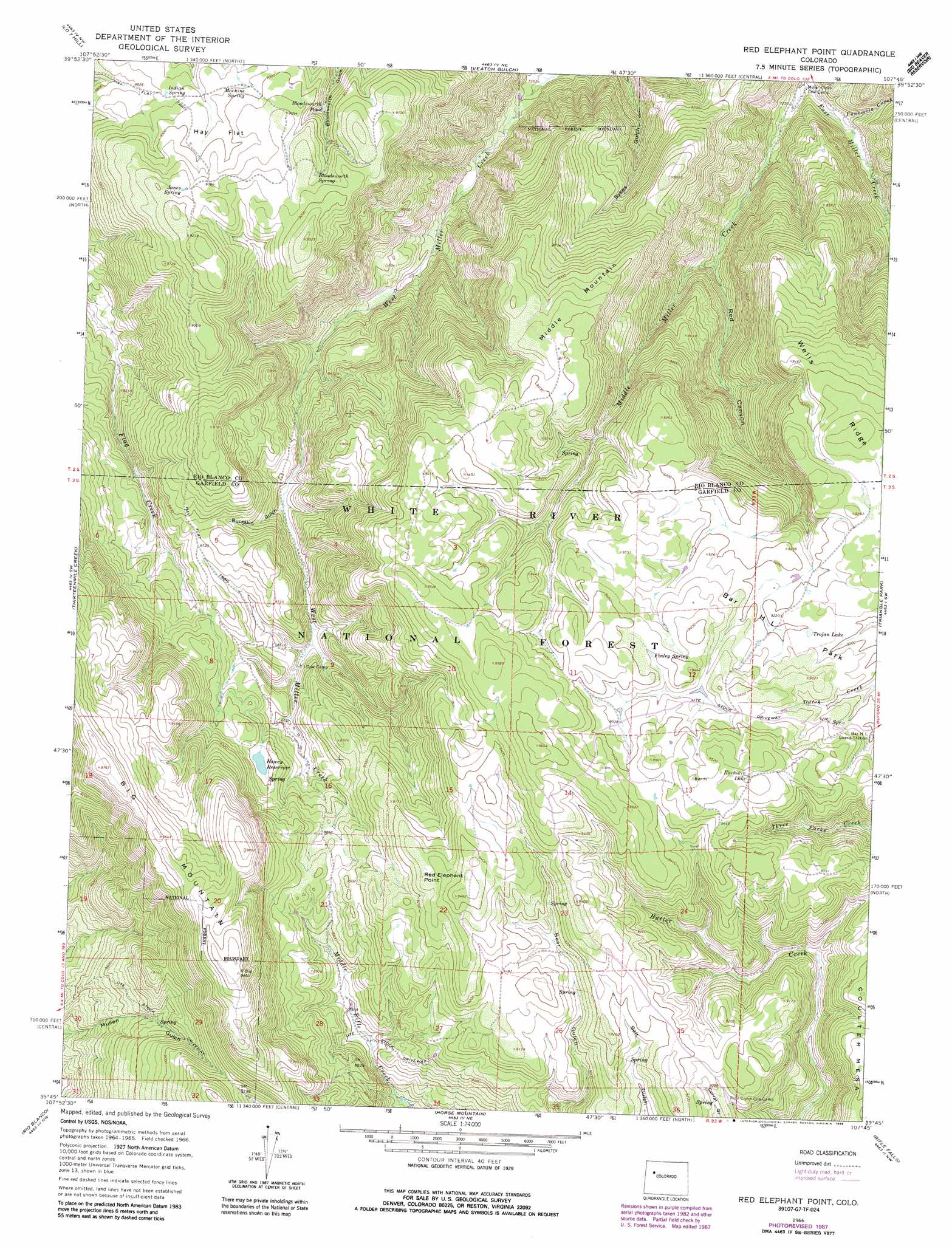
USGS Topo Quad 39107g7 - 1:24,000 scale
| Topo Map Name: | Red Elephant Point |
| USGS Topo Quad ID: | 39107g7 |
| Print Size: | ca. 21 1/4" wide x 27" high |
| Southeast Coordinates: | 39.75° N latitude / 107.75° W longitude |
| Map Center Coordinates: | 39.8125° N latitude / 107.8125° W longitude |
| U.S. State: | CO |
| Filename: | o39107g7.jpg |
| Download Map JPG Image: | Red Elephant Point topo map 1:24,000 scale |
| Map Type: | Topographic |
| Topo Series: | 7.5´ |
| Map Scale: | 1:24,000 |
| Source of Map Images: | United States Geological Survey (USGS) |
| Alternate Map Versions: |
Red Elephant Point CO 1966, updated 1969 Download PDF Buy paper map Red Elephant Point CO 1966, updated 1969 Download PDF Buy paper map Red Elephant Point CO 1966, updated 1988 Download PDF Buy paper map Red Elephant Point CO 1966, updated 1988 Download PDF Buy paper map Red Elephant Point CO 2011 Download PDF Buy paper map Red Elephant Point CO 2013 Download PDF Buy paper map Red Elephant Point CO 2016 Download PDF Buy paper map |
| FStopo: | US Forest Service topo Red Elephant Point is available: Download FStopo PDF Download FStopo TIF |
1:24,000 Topo Quads surrounding Red Elephant Point
Buckskin Point |
Meeker |
Rattlesnake Mesa |
Sawmill Mountain |
Fawn Creek |
Segar Mountain |
Lo 7 Hill |
Veatch Gulch |
Big Beaver Reservoir |
Buford |
No Name Ridge |
Thirteenmile Creek |
Red Elephant Point |
Triangle Park |
Meadow Creek Lake |
Mccarthy Gulch |
Rio Blanco |
Horse Mountain |
Rifle Falls |
Deep Creek Point |
Forked Gulch |
Anvil Points |
Rifle |
Silt |
New Castle |
> Back to 39107e1 at 1:100,000 scale
> Back to 39106a1 at 1:250,000 scale
> Back to U.S. Topo Maps home
Red Elephant Point topo map: Gazetteer
Red Elephant Point: Cliffs
Red Elephant Point elevation 2826m 9271′Red Elephant Point: Dams
Howey Reservoir Dam elevation 2676m 8779′Red Elephant Point: Flats
Bar H L Park elevation 2807m 9209′Hay Flat elevation 2738m 8982′
Red Elephant Point: Lakes
Bloodsworth Pond elevation 2692m 8832′Buckskin Lake elevation 2889m 9478′
Trojan Lake elevation 2808m 9212′
Red Elephant Point: Reservoirs
Howey Reservoir elevation 2676m 8779′Red Elephant Point: Ridges
Wells Ridge elevation 2846m 9337′Red Elephant Point: Springs
Bloodsworth Spring elevation 2765m 9071′Finley Spring elevation 2854m 9363′
Indian Spring elevation 2713m 8900′
Janes Spring elevation 2788m 9146′
Machine Spring elevation 2731m 8959′
Red Elephant Point: Streams
Fourmile Creek elevation 2221m 7286′Middle Miller Creek elevation 2196m 7204′
Red Elephant Point: Summits
Big Mountain elevation 3006m 9862′Middle Mountain elevation 2810m 9219′
Red Elephant Point: Trails
Hay Flat Trail elevation 2796m 9173′Ute Stock Driveway elevation 2557m 8389′
Red Elephant Point: Valleys
Buckskin Gulch elevation 2548m 8359′Red Canyon elevation 2305m 7562′
Red Elephant Point digital topo map on disk
Buy this Red Elephant Point topo map showing relief, roads, GPS coordinates and other geographical features, as a high-resolution digital map file on DVD: