Mesa Topo Map Colorado
To zoom in, hover over the map of Mesa
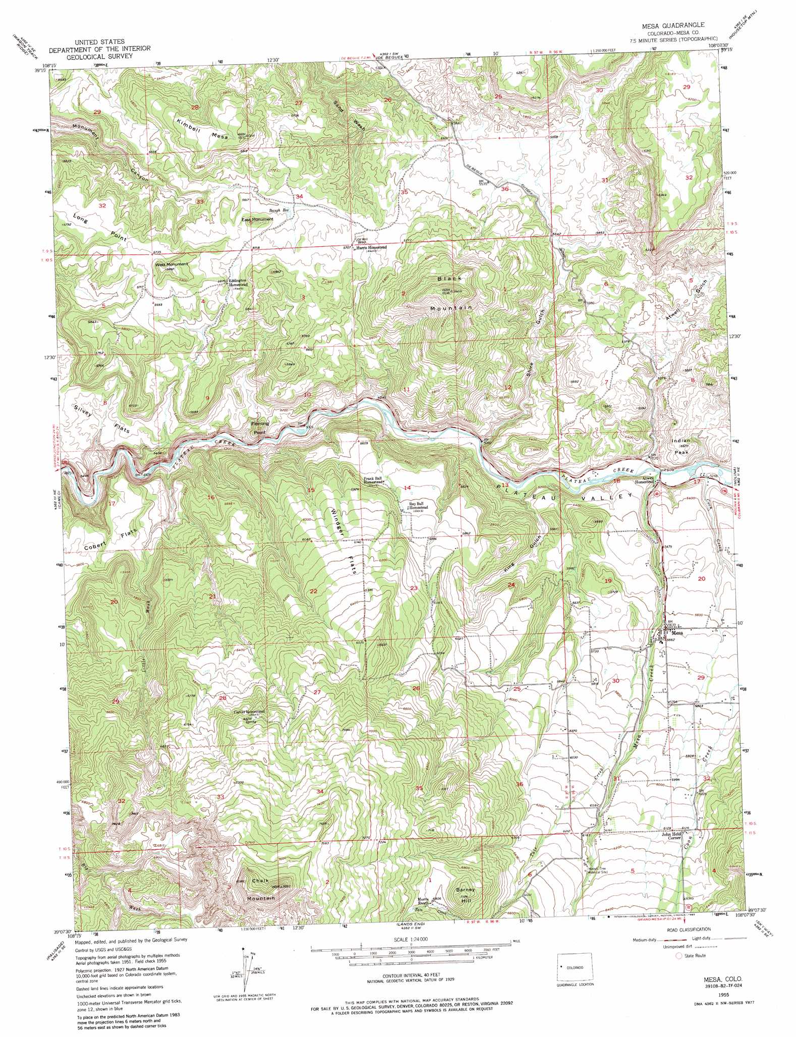
USGS Topo Quad 39108b2 - 1:24,000 scale
| Topo Map Name: | Mesa |
| USGS Topo Quad ID: | 39108b2 |
| Print Size: | ca. 21 1/4" wide x 27" high |
| Southeast Coordinates: | 39.125° N latitude / 108.125° W longitude |
| Map Center Coordinates: | 39.1875° N latitude / 108.1875° W longitude |
| U.S. State: | CO |
| Filename: | o39108b2.jpg |
| Download Map JPG Image: | Mesa topo map 1:24,000 scale |
| Map Type: | Topographic |
| Topo Series: | 7.5´ |
| Map Scale: | 1:24,000 |
| Source of Map Images: | United States Geological Survey (USGS) |
| Alternate Map Versions: |
Mesa CO 1955, updated 1957 Download PDF Buy paper map Mesa CO 1955, updated 1964 Download PDF Buy paper map Mesa CO 1955, updated 1964 Download PDF Buy paper map Mesa CO 1955, updated 1974 Download PDF Buy paper map Mesa CO 1955, updated 1974 Download PDF Buy paper map Mesa CO 1955, updated 1985 Download PDF Buy paper map Mesa CO 2010 Download PDF Buy paper map Mesa CO 2013 Download PDF Buy paper map Mesa CO 2016 Download PDF Buy paper map |
1:24,000 Topo Quads surrounding Mesa
The Saddle |
Long Point |
Red Pinnacle |
Parachute |
Rulison |
Winter Flats |
Wagon Track Ridge |
De Beque |
Housetop Mountain |
Hawxhurst Creek |
Round Mountain |
Cameo |
Mesa |
Molina |
Collbran |
Clifton |
Palisade |
Lands End |
Mesa Lakes |
Grand Mesa |
Whitewater |
Juniata Reservoir |
Indian Point |
Hells Kitchen |
Cedaredge |
> Back to 39108a1 at 1:100,000 scale
> Back to 39108a1 at 1:250,000 scale
> Back to U.S. Topo Maps home
Mesa topo map: Gazetteer
Mesa: Cliffs
Fleming Point elevation 1641m 5383′Mesa: Flats
Cobert Flats elevation 1856m 6089′Silvey Flats elevation 1605m 5265′
Windger Flats elevation 1878m 6161′
Mesa: Pillars
East Monument elevation 1765m 5790′Mesa: Populated Places
John Held Corner elevation 1866m 6122′Mesa elevation 1718m 5636′
Mesa: Reservoirs
Baugh Reservoir elevation 1716m 5629′Mesa: Streams
Coon Creek elevation 1582m 5190′Little Wash elevation 1510m 4954′
Mesa Creek elevation 1576m 5170′
Tate Creek elevation 1705m 5593′
Mesa: Summits
Barney Hill elevation 2168m 7112′Black Mountain elevation 2011m 6597′
Chalk Mountain elevation 2466m 8090′
Indian Peak elevation 1682m 5518′
Kimbell Mesa elevation 1843m 6046′
Long Point elevation 1761m 5777′
West Monument elevation 1790m 5872′
Mesa: Valleys
Atwell Gulch elevation 1576m 5170′King Gulch elevation 1748m 5734′
Plateau Valley elevation 1545m 5068′
Shire Gulch elevation 1544m 5065′
Mesa digital topo map on disk
Buy this Mesa topo map showing relief, roads, GPS coordinates and other geographical features, as a high-resolution digital map file on DVD: