Tenmile Canyon North Topo Map Utah
To zoom in, hover over the map of Tenmile Canyon North
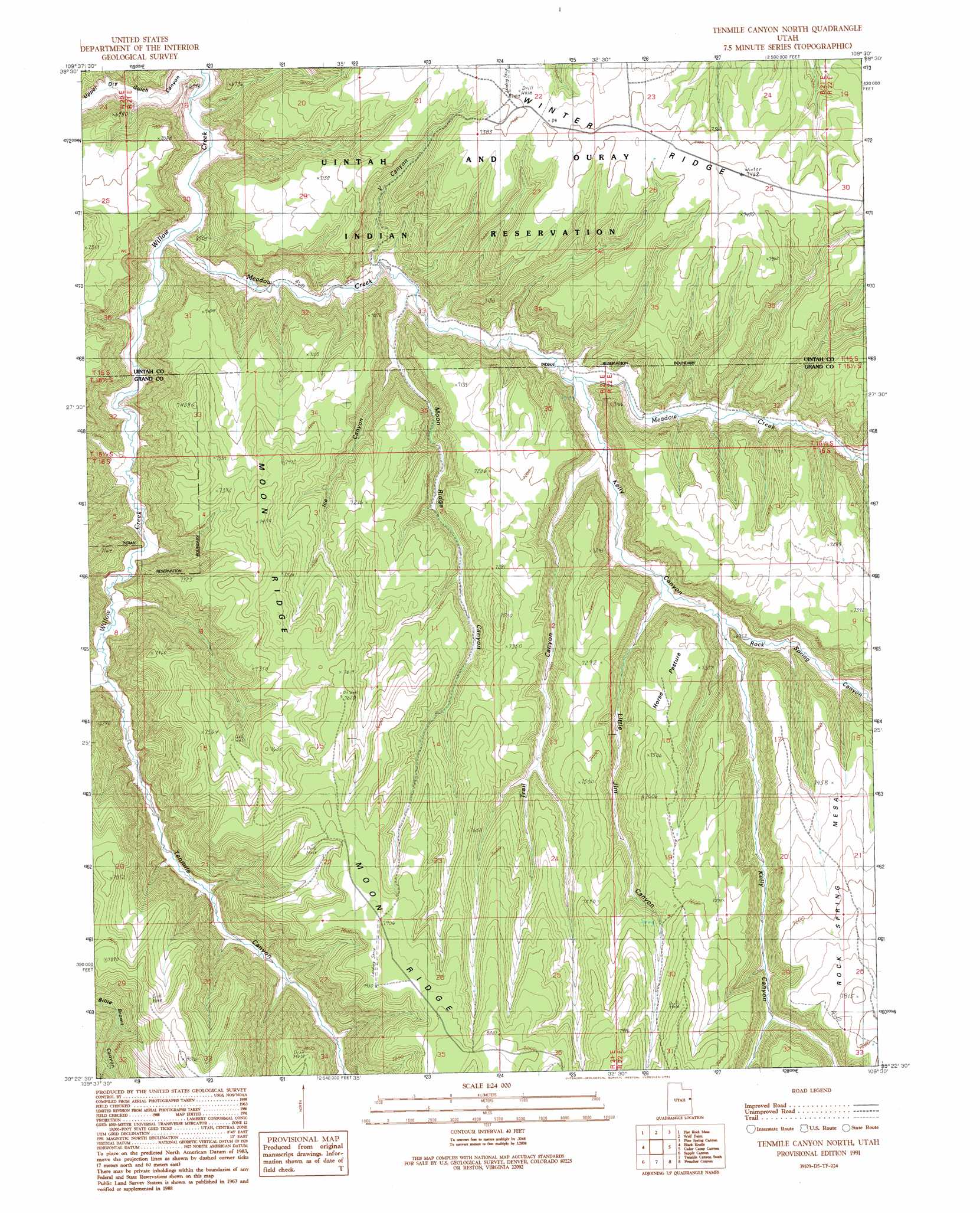
USGS Topo Quad 39109d5 - 1:24,000 scale
| Topo Map Name: | Tenmile Canyon North |
| USGS Topo Quad ID: | 39109d5 |
| Print Size: | ca. 21 1/4" wide x 27" high |
| Southeast Coordinates: | 39.375° N latitude / 109.5° W longitude |
| Map Center Coordinates: | 39.4375° N latitude / 109.5625° W longitude |
| U.S. State: | UT |
| Filename: | o39109d5.jpg |
| Download Map JPG Image: | Tenmile Canyon North topo map 1:24,000 scale |
| Map Type: | Topographic |
| Topo Series: | 7.5´ |
| Map Scale: | 1:24,000 |
| Source of Map Images: | United States Geological Survey (USGS) |
| Alternate Map Versions: |
Tenmile Canyon North UT 1991, updated 1991 Download PDF Buy paper map Tenmile Canyon North UT 2011 Download PDF Buy paper map Tenmile Canyon North UT 2014 Download PDF Buy paper map |
1:24,000 Topo Quads surrounding Tenmile Canyon North
Dog Knoll |
Agency Draw Nw |
Agency Draw Ne |
Bates Knolls |
Cooper Canyon |
Wolf Flat |
Flat Rock Mesa |
Wolf Point |
Pine Spring Canyon |
Seep Canyon |
Chicken Fork |
Black Knolls |
Tenmile Canyon North |
Cedar Camp Canyon |
P R Spring |
Walker Point |
Supply Canyon |
Tenmile Canyon South |
Preacher Canyon |
Dry Canyon |
Floy Canyon North |
Bogart Canyon |
Tepee Canyon |
Flume Canyon |
Antone Canyon |
> Back to 39109a1 at 1:100,000 scale
> Back to 39108a1 at 1:250,000 scale
> Back to U.S. Topo Maps home
Tenmile Canyon North topo map: Gazetteer
Tenmile Canyon North: Ridges
Moon Ridge elevation 2381m 7811′Winter Ridge elevation 2261m 7417′
Tenmile Canyon North: Streams
Meadow Creek elevation 1912m 6272′Tenmile Canyon North: Summits
Rock Spring Mesa elevation 2380m 7808′Tenmile Canyon North: Valleys
Ice Canyon elevation 2005m 6578′Kelly Canyon elevation 1997m 6551′
Little Jim Canyon elevation 2052m 6732′
Moon Ridge Canyon elevation 1967m 6453′
Rock Spring Canyon elevation 2056m 6745′
Tenmile Canyon elevation 1965m 6446′
Trail Canyon elevation 2019m 6624′
Upper Dry Gulch Canyon elevation 1906m 6253′
V Canyon elevation 1959m 6427′
Tenmile Canyon North digital topo map on disk
Buy this Tenmile Canyon North topo map showing relief, roads, GPS coordinates and other geographical features, as a high-resolution digital map file on DVD: