Wolf Point Topo Map Utah
To zoom in, hover over the map of Wolf Point
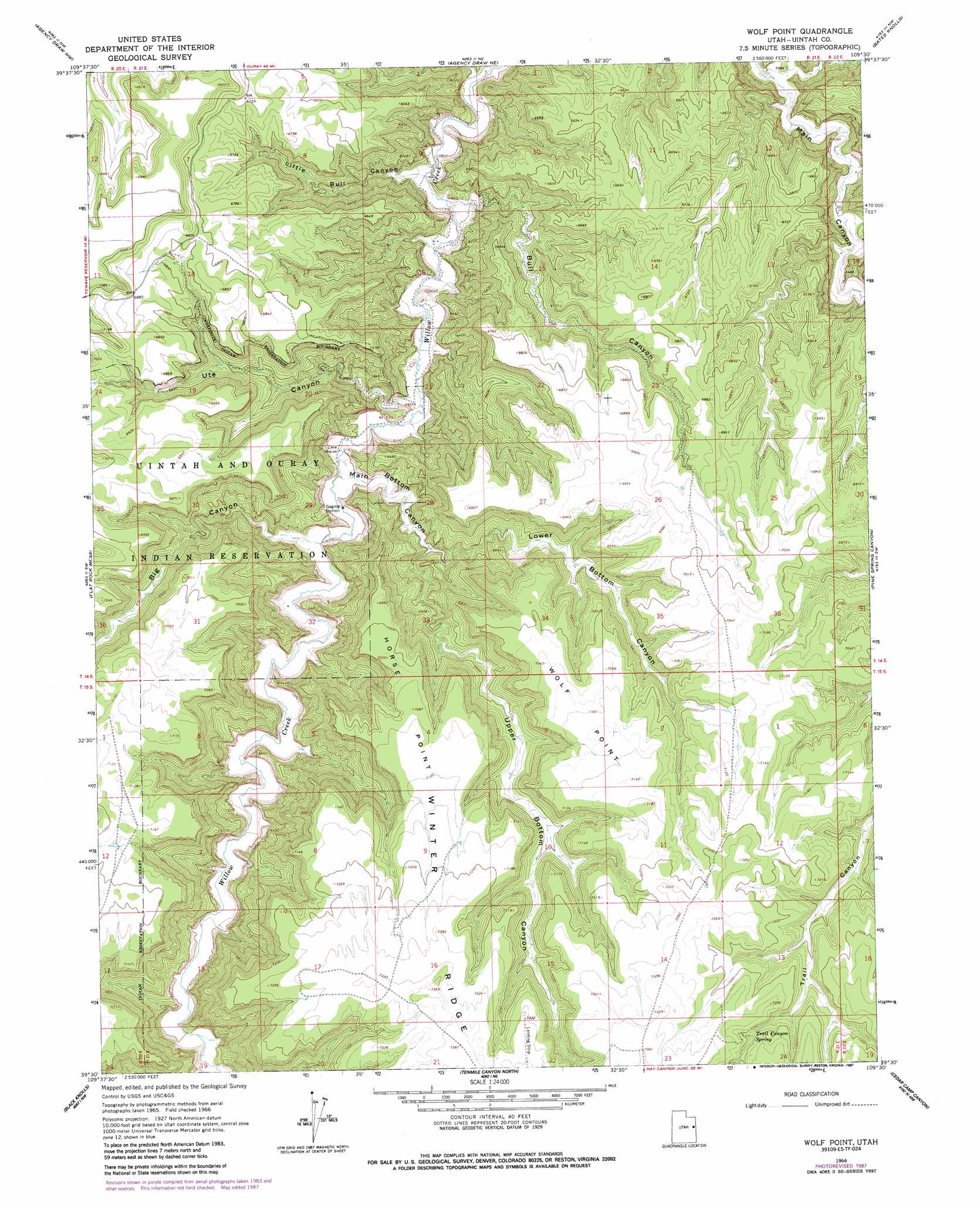
USGS Topo Quad 39109e5 - 1:24,000 scale
| Topo Map Name: | Wolf Point |
| USGS Topo Quad ID: | 39109e5 |
| Print Size: | ca. 21 1/4" wide x 27" high |
| Southeast Coordinates: | 39.5° N latitude / 109.5° W longitude |
| Map Center Coordinates: | 39.5625° N latitude / 109.5625° W longitude |
| U.S. State: | UT |
| Filename: | o39109e5.jpg |
| Download Map JPG Image: | Wolf Point topo map 1:24,000 scale |
| Map Type: | Topographic |
| Topo Series: | 7.5´ |
| Map Scale: | 1:24,000 |
| Source of Map Images: | United States Geological Survey (USGS) |
| Alternate Map Versions: |
Wolf Point UT 1966, updated 1970 Download PDF Buy paper map Wolf Point UT 1966, updated 1987 Download PDF Buy paper map Wolf Point UT 2011 Download PDF Buy paper map Wolf Point UT 2014 Download PDF Buy paper map |
1:24,000 Topo Quads surrounding Wolf Point
Nutters Hole |
Big Pack Mountain |
Big Pack Mountain Se |
Buck Camp Canyon |
Archy Bench Se |
Dog Knoll |
Agency Draw Nw |
Agency Draw Ne |
Bates Knolls |
Cooper Canyon |
Wolf Flat |
Flat Rock Mesa |
Wolf Point |
Pine Spring Canyon |
Seep Canyon |
Chicken Fork |
Black Knolls |
Tenmile Canyon North |
Cedar Camp Canyon |
P R Spring |
Walker Point |
Supply Canyon |
Tenmile Canyon South |
Preacher Canyon |
Dry Canyon |
> Back to 39109e1 at 1:100,000 scale
> Back to 39108a1 at 1:250,000 scale
> Back to U.S. Topo Maps home
Wolf Point topo map: Gazetteer
Wolf Point: Capes
Horse Point elevation 2151m 7057′Wolf Point elevation 2145m 7037′
Wolf Point: Dams
Weaver Dam elevation 2087m 6847′Wolf Point: Springs
Trail Canyon Spring elevation 2176m 7139′Wolf Point: Valleys
Big Canyon elevation 1836m 6023′Bull Canyon elevation 1806m 5925′
Little Bull Canyon elevation 1782m 5846′
Lower Bottom Canyon elevation 1904m 6246′
Main Bottom Canyon elevation 1825m 5987′
Upper Bottom Canyon elevation 1887m 6190′
Ute Canyon elevation 1812m 5944′
Window Canyon elevation 1829m 6000′
Wolf Point digital topo map on disk
Buy this Wolf Point topo map showing relief, roads, GPS coordinates and other geographical features, as a high-resolution digital map file on DVD: