Big Pack Mountain Se Topo Map Utah
To zoom in, hover over the map of Big Pack Mountain Se
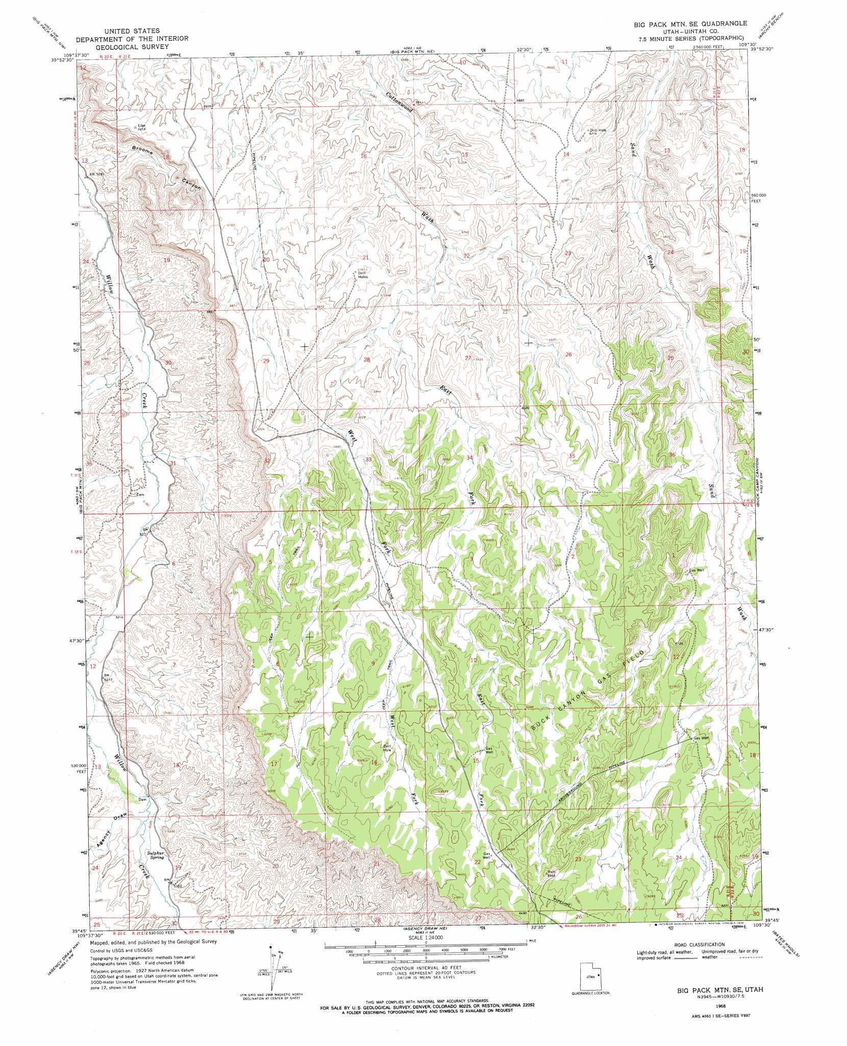
USGS Topo Quad 39109g5 - 1:24,000 scale
| Topo Map Name: | Big Pack Mountain Se |
| USGS Topo Quad ID: | 39109g5 |
| Print Size: | ca. 21 1/4" wide x 27" high |
| Southeast Coordinates: | 39.75° N latitude / 109.5° W longitude |
| Map Center Coordinates: | 39.8125° N latitude / 109.5625° W longitude |
| U.S. State: | UT |
| Filename: | o39109g5.jpg |
| Download Map JPG Image: | Big Pack Mountain Se topo map 1:24,000 scale |
| Map Type: | Topographic |
| Topo Series: | 7.5´ |
| Map Scale: | 1:24,000 |
| Source of Map Images: | United States Geological Survey (USGS) |
| Alternate Map Versions: |
Big Pack Mtn. SE UT 1968, updated 1970 Download PDF Buy paper map Big Pack Mountain SE UT 2011 Download PDF Buy paper map Big Pack Mountain SE UT 2014 Download PDF Buy paper map |
1:24,000 Topo Quads surrounding Big Pack Mountain Se
Uteland Butte |
Ouray |
Ouray Se |
Red Wash Sw |
Red Wash Se |
Moon Bottom |
Big Pack Mountain Nw |
Big Pack Mountain Ne |
Archy Bench |
Asphalt Wash |
Nutters Hole |
Big Pack Mountain |
Big Pack Mountain Se |
Buck Camp Canyon |
Archy Bench Se |
Dog Knoll |
Agency Draw Nw |
Agency Draw Ne |
Bates Knolls |
Cooper Canyon |
Wolf Flat |
Flat Rock Mesa |
Wolf Point |
Pine Spring Canyon |
Seep Canyon |
> Back to 39109e1 at 1:100,000 scale
> Back to 39108a1 at 1:250,000 scale
> Back to U.S. Topo Maps home
Big Pack Mountain Se topo map: Gazetteer
Big Pack Mountain Se: Oilfields
Buck Canyon Gas Field elevation 1828m 5997′Big Pack Mountain Se: Springs
Sulphur Spring elevation 1633m 5357′Big Pack Mountain Se: Valleys
Agency Draw elevation 1622m 5321′Broome Canyon elevation 1554m 5098′
East Fork Cottonwood Wash elevation 1735m 5692′
West Fork Cottonwood Wash elevation 1738m 5702′
Big Pack Mountain Se digital topo map on disk
Buy this Big Pack Mountain Se topo map showing relief, roads, GPS coordinates and other geographical features, as a high-resolution digital map file on DVD: