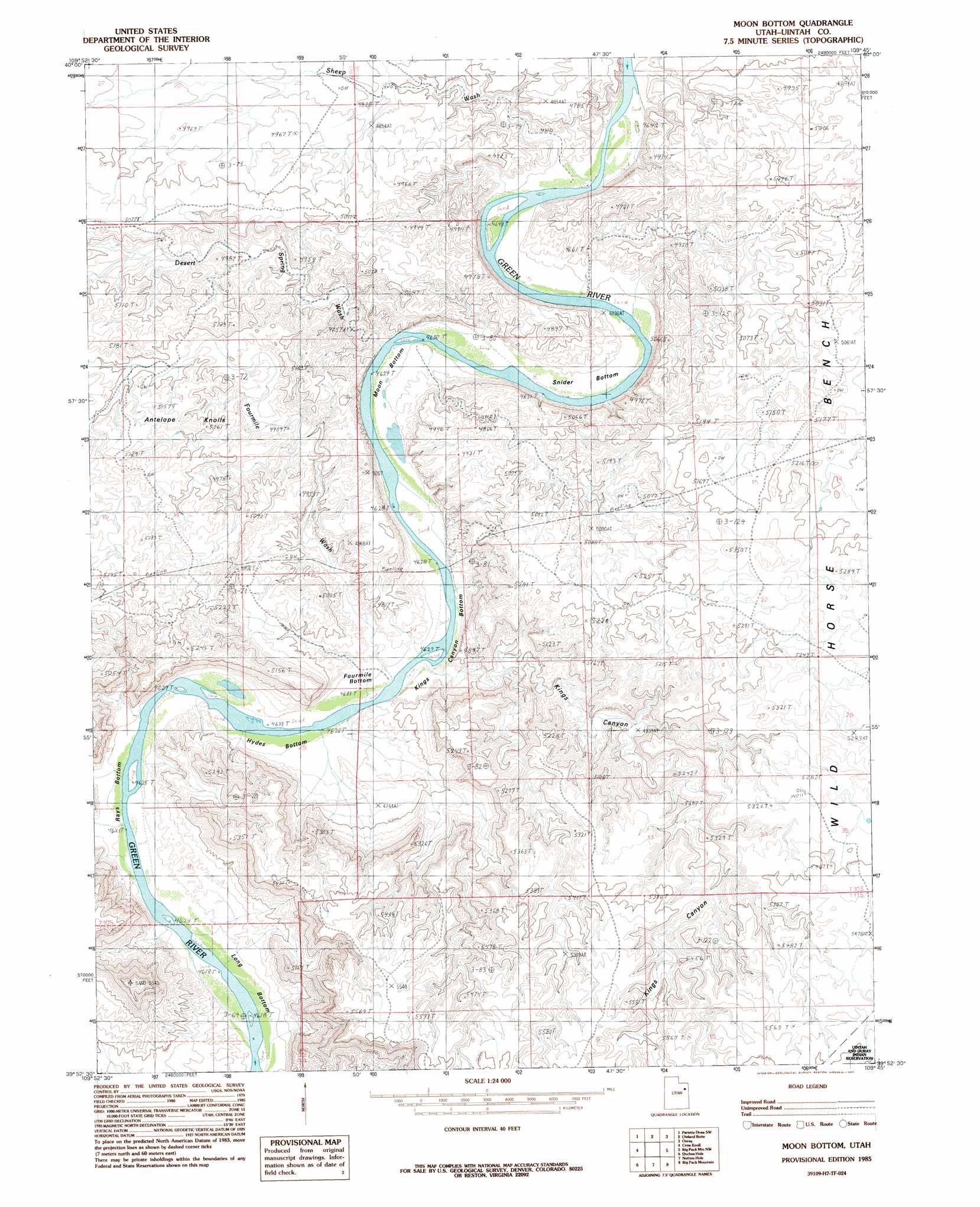
Moon Bottom Topo Map Utah
To zoom in, hover over the map of Moon Bottom
USGS Topo Quad 39109h7 - 1:24,000 scale
| Topo Map Name: | Moon Bottom |
| USGS Topo Quad ID: | 39109h7 |
| Print Size: | ca. 21 1/4" wide x 27" high |
| Southeast Coordinates: | 39.875° N latitude / 109.75° W longitude |
| Map Center Coordinates: | 39.9375° N latitude / 109.8125° W longitude |
| U.S. State: | UT |
| Filename: | o39109h7.jpg |
| Download Map JPG Image: | Moon Bottom topo map 1:24,000 scale |
| Map Type: | Topographic |
| Topo Series: | 7.5´ |
| Map Scale: | 1:24,000 |
| Source of Map Images: | United States Geological Survey (USGS) |
| Alternate Map Versions: |
Moon Bottom UT 1985, updated 1985 Download PDF Buy paper map Moon Bottom UT 2011 Download PDF Buy paper map Moon Bottom UT 2014 Download PDF Buy paper map |
1:24,000 Topo Quads surrounding Moon Bottom
Myton |
Windy Ridge |
Randlett |
Pelican Lake |
Brennan Basin |
Myton Se |
Pariette Draw Sw |
Uteland Butte |
Ouray |
Ouray Se |
Wilkin Ridge |
Crow Knoll |
Moon Bottom |
Big Pack Mountain Nw |
Big Pack Mountain Ne |
Pinnacle Canyon |
Duches Hole |
Nutters Hole |
Big Pack Mountain |
Big Pack Mountain Se |
Cedar Ridge Canyon |
Firewater Canyon North |
Dog Knoll |
Agency Draw Nw |
Agency Draw Ne |
> Back to 39109e1 at 1:100,000 scale
> Back to 39108a1 at 1:250,000 scale
> Back to U.S. Topo Maps home
Moon Bottom topo map: Gazetteer
Moon Bottom: Benches
Wild Horse Bench elevation 1576m 5170′Moon Bottom: Bends
Fourmile Bottom elevation 1414m 4639′Hydes Bottom elevation 1411m 4629′
Kings Canyon Bottom elevation 1413m 4635′
Long Bottom elevation 1411m 4629′
Moon Bottom elevation 1413m 4635′
Rays Bottom elevation 1411m 4629′
Snider Bottom elevation 1413m 4635′
Moon Bottom: Summits
Antelope Knolls elevation 1541m 5055′Moon Bottom: Valleys
Desert Spring Wash elevation 1423m 4668′Fourmile Wash elevation 1416m 4645′
Kings Canyon elevation 1437m 4714′
Sheep Wash elevation 1418m 4652′
Moon Bottom digital topo map on disk
Buy this Moon Bottom topo map showing relief, roads, GPS coordinates and other geographical features, as a high-resolution digital map file on DVD: