Poison Spring Bench Topo Map Utah
To zoom in, hover over the map of Poison Spring Bench
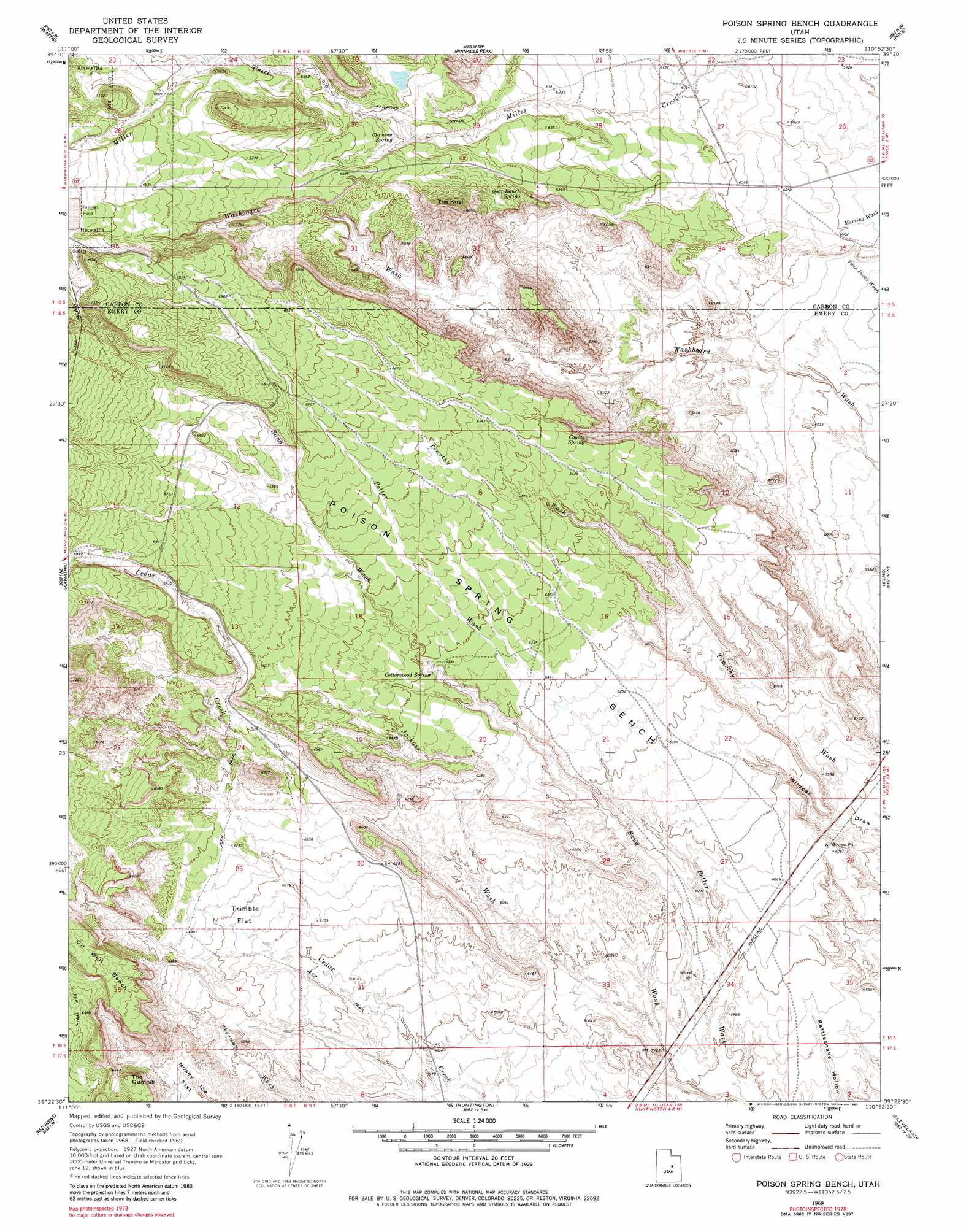
USGS Topo Quad 39110d8 - 1:24,000 scale
| Topo Map Name: | Poison Spring Bench |
| USGS Topo Quad ID: | 39110d8 |
| Print Size: | ca. 21 1/4" wide x 27" high |
| Southeast Coordinates: | 39.375° N latitude / 110.875° W longitude |
| Map Center Coordinates: | 39.4375° N latitude / 110.9375° W longitude |
| U.S. State: | UT |
| Filename: | o39110d8.jpg |
| Download Map JPG Image: | Poison Spring Bench topo map 1:24,000 scale |
| Map Type: | Topographic |
| Topo Series: | 7.5´ |
| Map Scale: | 1:24,000 |
| Source of Map Images: | United States Geological Survey (USGS) |
| Alternate Map Versions: |
Poison Spring Bench UT 1969, updated 1972 Download PDF Buy paper map Poison Spring Bench UT 1969, updated 1983 Download PDF Buy paper map Poison Spring Bench UT 1969, updated 1983 Download PDF Buy paper map Poison Spring Bench UT 2011 Download PDF Buy paper map Poison Spring Bench UT 2014 Download PDF Buy paper map |
1:24,000 Topo Quads surrounding Poison Spring Bench
Scofield |
Jump Creek |
Standardville |
Helper |
Deadman Canyon |
Candland Mountain |
Wattis |
Pinnacle Peak |
Price |
Wellington |
Rilda Canyon |
Hiawatha |
Poison Spring Bench |
Elmo |
Olsen Reservoir |
Mahogany Point |
Red Point |
Huntington |
Cleveland |
Cow Flats |
The Cap |
Castle Dale |
Hadden Holes |
Buckhorn Reservoir |
Bob Hill Knoll |
> Back to 39110a1 at 1:100,000 scale
> Back to 39110a1 at 1:250,000 scale
> Back to U.S. Topo Maps home
Poison Spring Bench topo map: Gazetteer
Poison Spring Bench: Benches
Poison Spring Bench elevation 1970m 6463′Poison Spring Bench: Dams
Millerton Dam elevation 1993m 6538′Poison Spring Bench: Flats
Trimble Flat elevation 1888m 6194′Poison Spring Bench: Reservoirs
Millerton Reservoir elevation 1993m 6538′Poison Spring Bench: Springs
Clawson Spring elevation 1984m 6509′Cottonwood Spring elevation 1933m 6341′
Coyote Spring elevation 1926m 6318′
Goat Ranch Spring elevation 1931m 6335′
Poison Spring Bench: Summits
The Knoll elevation 2100m 6889′Poison Spring Bench: Valleys
Jackass Wash elevation 1802m 5912′Poison Spring Bench digital topo map on disk
Buy this Poison Spring Bench topo map showing relief, roads, GPS coordinates and other geographical features, as a high-resolution digital map file on DVD: