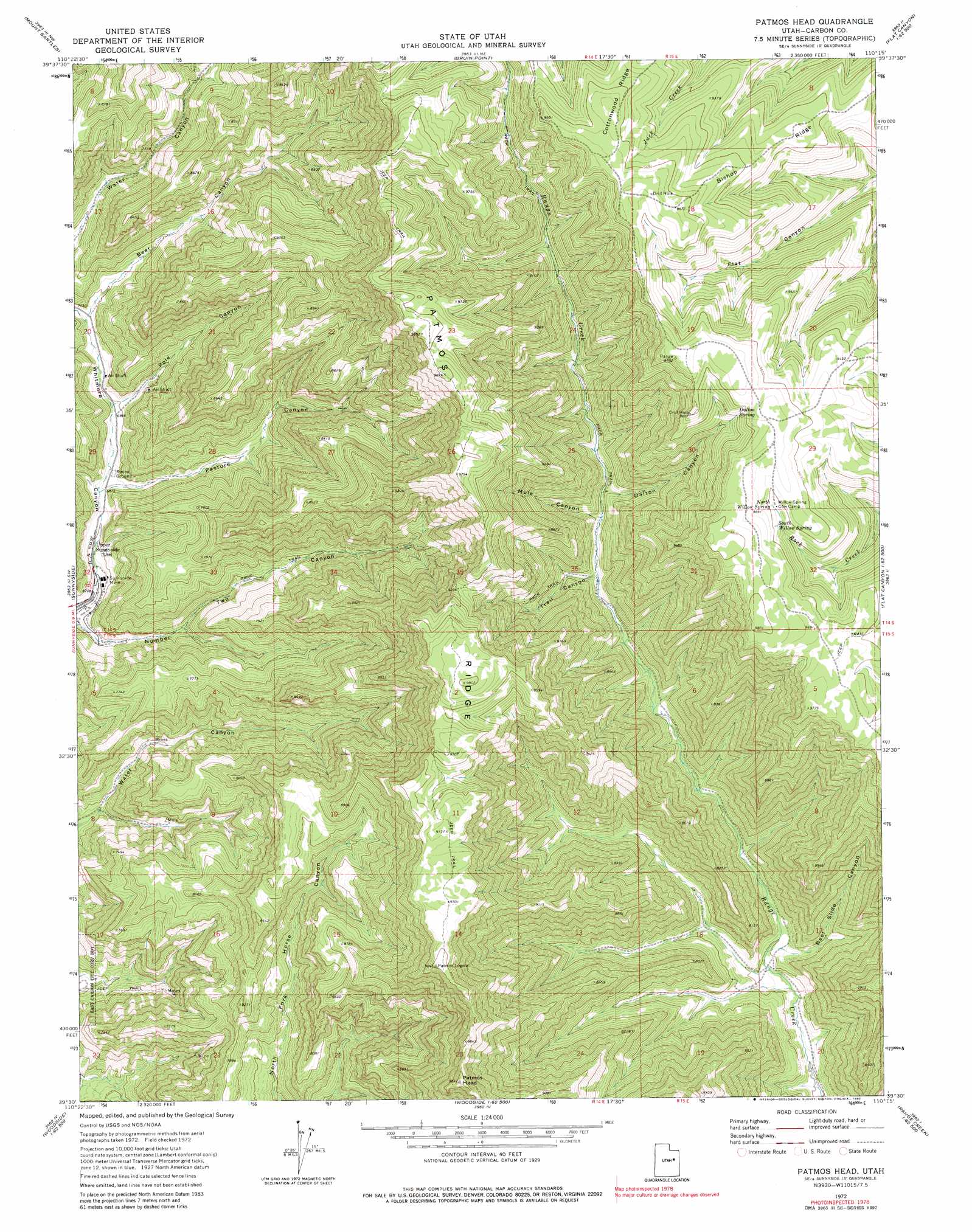
Patmos Head Topo Map Utah
To zoom in, hover over the map of Patmos Head
USGS Topo Quad 39110e3 - 1:24,000 scale
| Topo Map Name: | Patmos Head |
| USGS Topo Quad ID: | 39110e3 |
| Print Size: | ca. 21 1/4" wide x 27" high |
| Southeast Coordinates: | 39.5° N latitude / 110.25° W longitude |
| Map Center Coordinates: | 39.5625° N latitude / 110.3125° W longitude |
| U.S. State: | UT |
| Filename: | o39110e3.jpg |
| Download Map JPG Image: | Patmos Head topo map 1:24,000 scale |
| Map Type: | Topographic |
| Topo Series: | 7.5´ |
| Map Scale: | 1:24,000 |
| Source of Map Images: | United States Geological Survey (USGS) |
| Alternate Map Versions: |
Patmos Head UT 1972, updated 1976 Download PDF Buy paper map Patmos Head UT 1972, updated 1980 Download PDF Buy paper map Patmos Head UT 2011 Download PDF Buy paper map Patmos Head UT 2014 Download PDF Buy paper map |
1:24,000 Topo Quads surrounding Patmos Head
Minnie Maud Creek East |
Wood Canyon |
Currant Canyon |
Cowboy Bench |
Pinnacle Canyon |
Pine Canyon |
Mount Bartles |
Bruin Point |
Twin Hollow |
Cedar Ridge Canyon |
Sunnyside Junction |
Sunnyside |
Patmos Head |
Summerhouse Ridge |
Steer Ridge Canyon |
Mounds |
Cedar |
Lila Point |
Lighthouse Canyon |
Chandler Falls |
Flattop Mountain |
Grassy |
Woodside |
Turtle Canyon |
Three Fords Canyon |
> Back to 39110e1 at 1:100,000 scale
> Back to 39110a1 at 1:250,000 scale
> Back to U.S. Topo Maps home
Patmos Head topo map: Gazetteer
Patmos Head: Mines
Sunnyside Mine elevation 2061m 6761′Patmos Head: Populated Places
Upper Sunnyside elevation 2065m 6774′Patmos Head: Ridges
Bishop Ridge elevation 2840m 9317′Patmos Ridge elevation 2961m 9714′
Patmos Head: Springs
Dalton Spring elevation 2872m 9422′North Willow Spring elevation 2918m 9573′
South Willow Spring elevation 2919m 9576′
Patmos Head: Summits
Patmos Head elevation 2994m 9822′Range Valley Mountain elevation 2989m 9806′
Patmos Head: Valleys
Bear Canyon elevation 2178m 7145′Beef Slide Canyon elevation 2208m 7244′
Dalton Canyon elevation 2440m 8005′
Mule Canyon elevation 2419m 7936′
Pasture Canyon elevation 2102m 6896′
Pole Canyon elevation 2137m 7011′
Trail Canyon elevation 2394m 7854′
Patmos Head digital topo map on disk
Buy this Patmos Head topo map showing relief, roads, GPS coordinates and other geographical features, as a high-resolution digital map file on DVD: