Cedar Ridge Canyon Topo Map Utah
To zoom in, hover over the map of Cedar Ridge Canyon
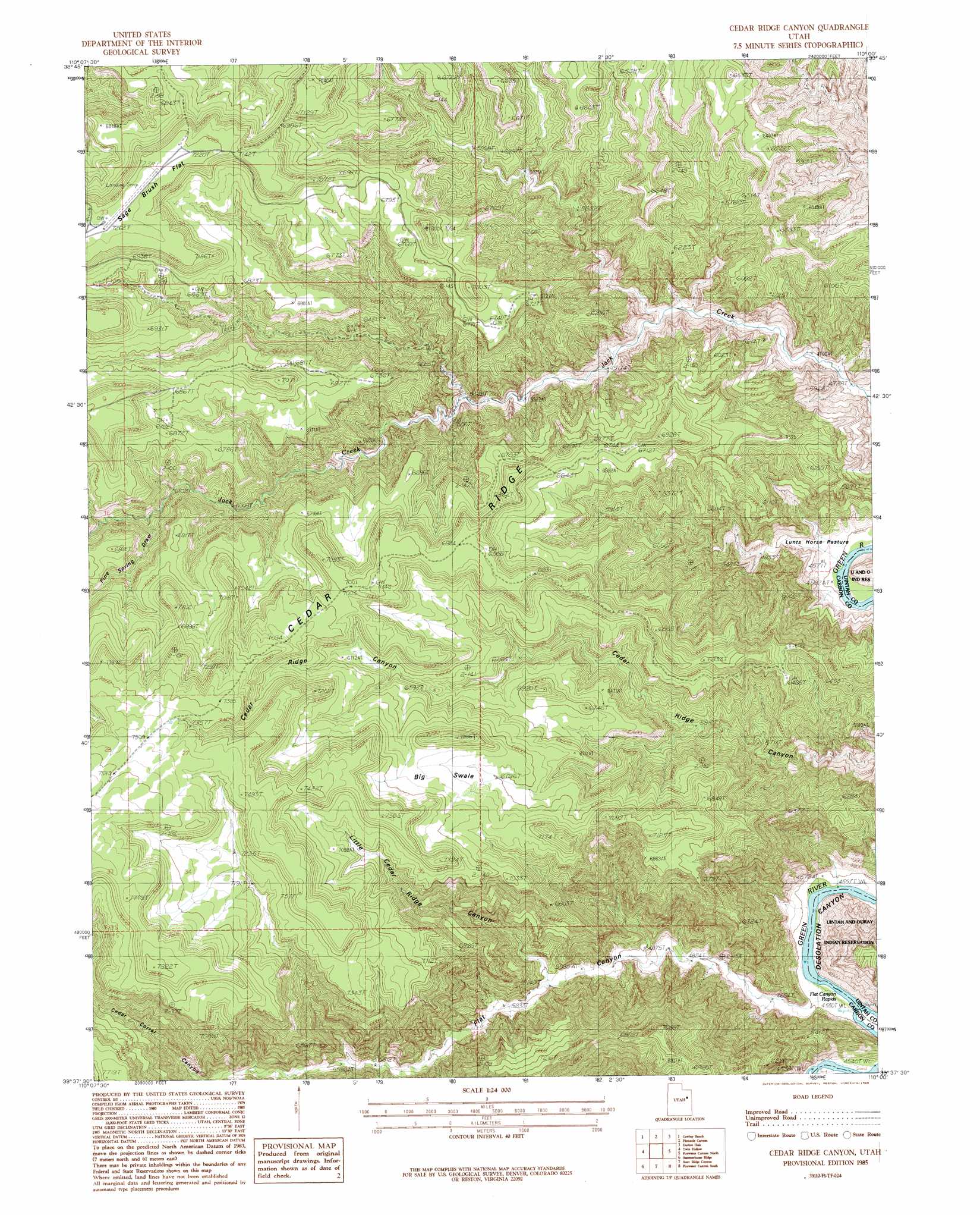
USGS Topo Quad 39110f1 - 1:24,000 scale
| Topo Map Name: | Cedar Ridge Canyon |
| USGS Topo Quad ID: | 39110f1 |
| Print Size: | ca. 21 1/4" wide x 27" high |
| Southeast Coordinates: | 39.625° N latitude / 110° W longitude |
| Map Center Coordinates: | 39.6875° N latitude / 110.0625° W longitude |
| U.S. State: | UT |
| Filename: | o39110f1.jpg |
| Download Map JPG Image: | Cedar Ridge Canyon topo map 1:24,000 scale |
| Map Type: | Topographic |
| Topo Series: | 7.5´ |
| Map Scale: | 1:24,000 |
| Source of Map Images: | United States Geological Survey (USGS) |
| Alternate Map Versions: |
Cedar Ridge Canyon UT 1985, updated 1985 Download PDF Buy paper map Cedar Ridge Canyon UT 2011 Download PDF Buy paper map Cedar Ridge Canyon UT 2014 Download PDF Buy paper map |
1:24,000 Topo Quads surrounding Cedar Ridge Canyon
Anthro Mountain Ne |
Gilsonite Draw |
Wilkin Ridge |
Crow Knoll |
Moon Bottom |
Currant Canyon |
Cowboy Bench |
Pinnacle Canyon |
Duches Hole |
Nutters Hole |
Bruin Point |
Twin Hollow |
Cedar Ridge Canyon |
Firewater Canyon North |
Dog Knoll |
Patmos Head |
Summerhouse Ridge |
Steer Ridge Canyon |
Firewater Canyon South |
Wolf Flat |
Lila Point |
Lighthouse Canyon |
Chandler Falls |
Moonwater Point |
Chicken Fork |
> Back to 39110e1 at 1:100,000 scale
> Back to 39110a1 at 1:250,000 scale
> Back to U.S. Topo Maps home
Cedar Ridge Canyon topo map: Gazetteer
Cedar Ridge Canyon: Flats
Big Swale elevation 2089m 6853′Lunts Horse Pasture elevation 1432m 4698′
Cedar Ridge Canyon: Rapids
Flat Canyon Rapids elevation 1393m 4570′Cedar Ridge Canyon: Ridges
Cedar Ridge elevation 2138m 7014′Cedar Ridge Canyon: Valleys
Cedar Corral Canyon elevation 1838m 6030′Flat Canyon elevation 1413m 4635′
Little Cedar Ridge Canyon elevation 1579m 5180′
Pine Spring Draw elevation 1887m 6190′
Cedar Ridge Canyon digital topo map on disk
Buy this Cedar Ridge Canyon topo map showing relief, roads, GPS coordinates and other geographical features, as a high-resolution digital map file on DVD: