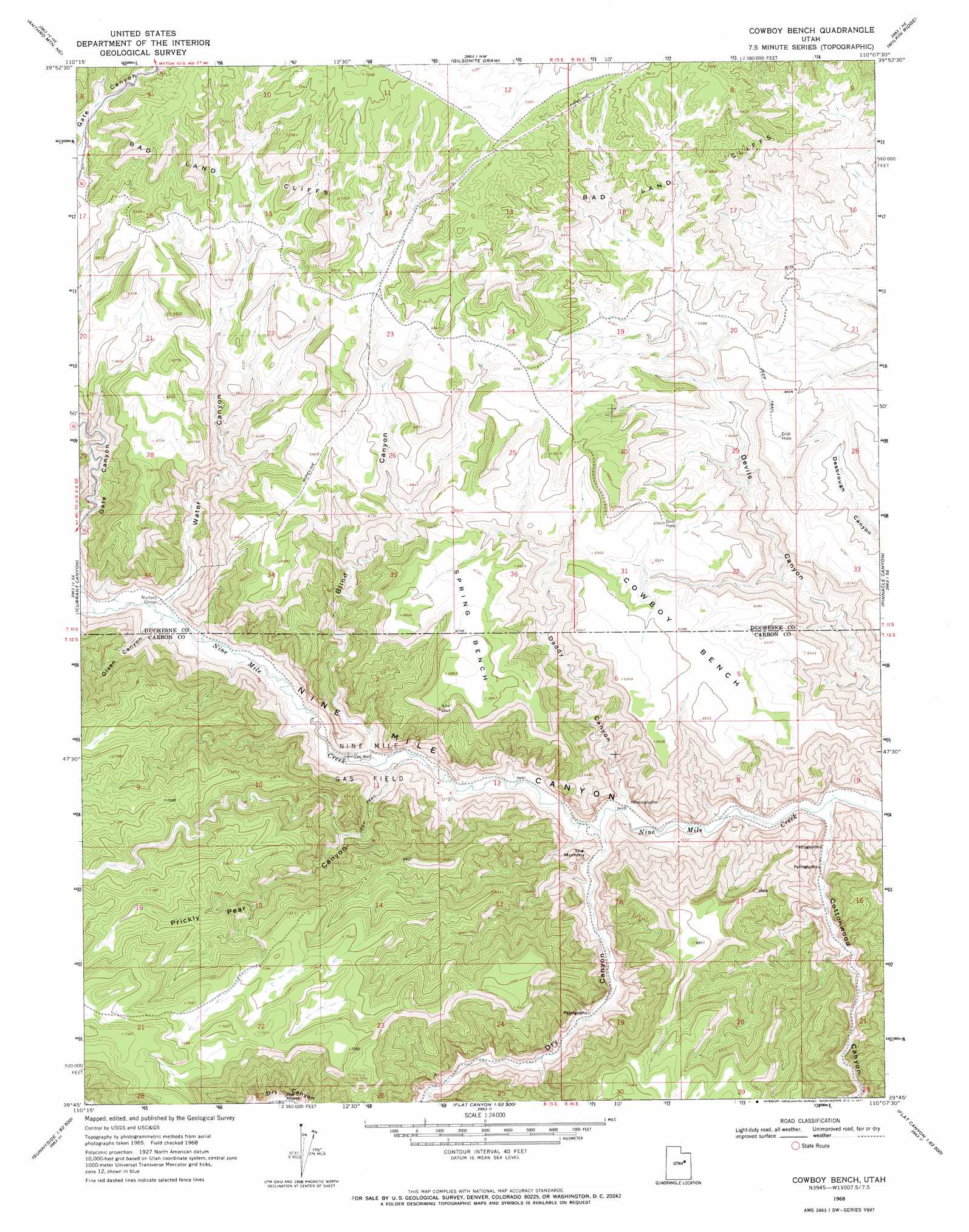
Cowboy Bench Topo Map Utah
To zoom in, hover over the map of Cowboy Bench
USGS Topo Quad 39110g2 - 1:24,000 scale
| Topo Map Name: | Cowboy Bench |
| USGS Topo Quad ID: | 39110g2 |
| Print Size: | ca. 21 1/4" wide x 27" high |
| Southeast Coordinates: | 39.75° N latitude / 110.125° W longitude |
| Map Center Coordinates: | 39.8125° N latitude / 110.1875° W longitude |
| U.S. State: | UT |
| Filename: | o39110g2.jpg |
| Download Map JPG Image: | Cowboy Bench topo map 1:24,000 scale |
| Map Type: | Topographic |
| Topo Series: | 7.5´ |
| Map Scale: | 1:24,000 |
| Source of Map Images: | United States Geological Survey (USGS) |
| Alternate Map Versions: |
Cowboy Bench UT 1968, updated 1971 Download PDF Buy paper map Cowboy Bench UT 2011 Download PDF Buy paper map Cowboy Bench UT 2014 Download PDF Buy paper map |
1:24,000 Topo Quads surrounding Cowboy Bench
Duchesne Sw |
Duchesne Se |
Myton Sw |
Myton Se |
Pariette Draw Sw |
Anthro Mountain |
Anthro Mountain Ne |
Gilsonite Draw |
Wilkin Ridge |
Crow Knoll |
Wood Canyon |
Currant Canyon |
Cowboy Bench |
Pinnacle Canyon |
Duches Hole |
Mount Bartles |
Bruin Point |
Twin Hollow |
Cedar Ridge Canyon |
Firewater Canyon North |
Sunnyside |
Patmos Head |
Summerhouse Ridge |
Steer Ridge Canyon |
Firewater Canyon South |
> Back to 39110e1 at 1:100,000 scale
> Back to 39110a1 at 1:250,000 scale
> Back to U.S. Topo Maps home
Cowboy Bench topo map: Gazetteer
Cowboy Bench: Arches
The Alcove elevation 1876m 6154′The Mummy elevation 1763m 5784′
Cowboy Bench: Benches
Cowboy Bench elevation 2006m 6581′Spring Bench elevation 2051m 6729′
Cowboy Bench: Cliffs
Bad Land Cliffs elevation 2169m 7116′Cowboy Bench: Oilfields
Nine Mile Gas Field elevation 1706m 5597′Cowboy Bench: Streams
Dry Creek elevation 1656m 5433′Cowboy Bench: Valleys
Blind Canyon elevation 1712m 5616′Cottonwood Canyon elevation 1631m 5351′
Daddy Canyon elevation 1666m 5465′
Dry Canyon elevation 1656m 5433′
Gate Canyon elevation 1754m 5754′
Olsen Canyon elevation 1758m 5767′
Prickly Pear Canyon elevation 1709m 5606′
Water Canyon elevation 1748m 5734′
Cowboy Bench digital topo map on disk
Buy this Cowboy Bench topo map showing relief, roads, GPS coordinates and other geographical features, as a high-resolution digital map file on DVD: