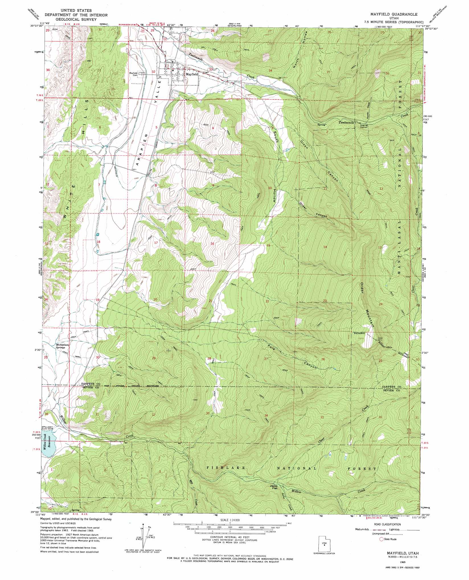
Mayfield Topo Map Utah
To zoom in, hover over the map of Mayfield
USGS Topo Quad 39111a6 - 1:24,000 scale
| Topo Map Name: | Mayfield |
| USGS Topo Quad ID: | 39111a6 |
| Print Size: | ca. 21 1/4" wide x 27" high |
| Southeast Coordinates: | 39° N latitude / 111.625° W longitude |
| Map Center Coordinates: | 39.0625° N latitude / 111.6875° W longitude |
| U.S. State: | UT |
| Filename: | o39111a6.jpg |
| Download Map JPG Image: | Mayfield topo map 1:24,000 scale |
| Map Type: | Topographic |
| Topo Series: | 7.5´ |
| Map Scale: | 1:24,000 |
| Source of Map Images: | United States Geological Survey (USGS) |
| Alternate Map Versions: |
Mayfield UT 1965, updated 1967 Download PDF Buy paper map Mayfield UT 1965, updated 1979 Download PDF Buy paper map Mayfield UT 2001, updated 2004 Download PDF Buy paper map Mayfield UT 2011 Download PDF Buy paper map Mayfield UT 2014 Download PDF Buy paper map |
| FStopo: | US Forest Service topo Mayfield is available: Download FStopo PDF Download FStopo TIF |
1:24,000 Topo Quads surrounding Mayfield
Hells Kitchen Canyon Sw |
Hells Kitchen Canyon Se |
Manti |
Ephraim |
Danish Knoll |
Hayes Canyon |
Gunnison |
Sterling |
Black Mountain |
Ferron Reservoir |
Redmond Canyon |
Redmond |
Mayfield |
Woods Lake |
Heliotrope Mountain |
Aurora |
Salina |
Steves Mountain |
Water Hollow Ridge |
Acord Lakes |
Sigurd |
Rex Reservoir |
Gooseberry Creek |
Yogo Creek |
Old Woman Plateau |
> Back to 39111a1 at 1:100,000 scale
> Back to 39110a1 at 1:250,000 scale
> Back to U.S. Topo Maps home
Mayfield topo map: Gazetteer
Mayfield: Flats
Jacks Flat elevation 2055m 6742′Mayfield: Parks
Mayfield Face Wildlife Management Area elevation 2102m 6896′Willow Creek Wildlife Management Area elevation 1908m 6259′
Mayfield: Populated Places
Mayfield elevation 1688m 5538′Mayfield: Ranges
White Hills elevation 1728m 5669′Mayfield: Springs
Michaelson Springs elevation 1692m 5551′Mayfield: Streams
Clear Creek elevation 2023m 6637′Clear Creek elevation 1862m 6108′
Jacks Creek elevation 2034m 6673′
Mill Creek elevation 1871m 6138′
North Pine Creek elevation 2061m 6761′
South Pine Creek elevation 2334m 7657′
Mayfield: Summits
Order Mountain elevation 2909m 9543′Mayfield: Valleys
North Cove elevation 1843m 6046′North Hollow elevation 1763m 5784′
Olsen Canyon elevation 1838m 6030′
Order Canyon elevation 1962m 6437′
Pole Canyon elevation 2069m 6788′
South Hollow elevation 1804m 5918′
Twelvemile Canyon elevation 1707m 5600′
Mayfield digital topo map on disk
Buy this Mayfield topo map showing relief, roads, GPS coordinates and other geographical features, as a high-resolution digital map file on DVD: