Redmond Topo Map Utah
To zoom in, hover over the map of Redmond
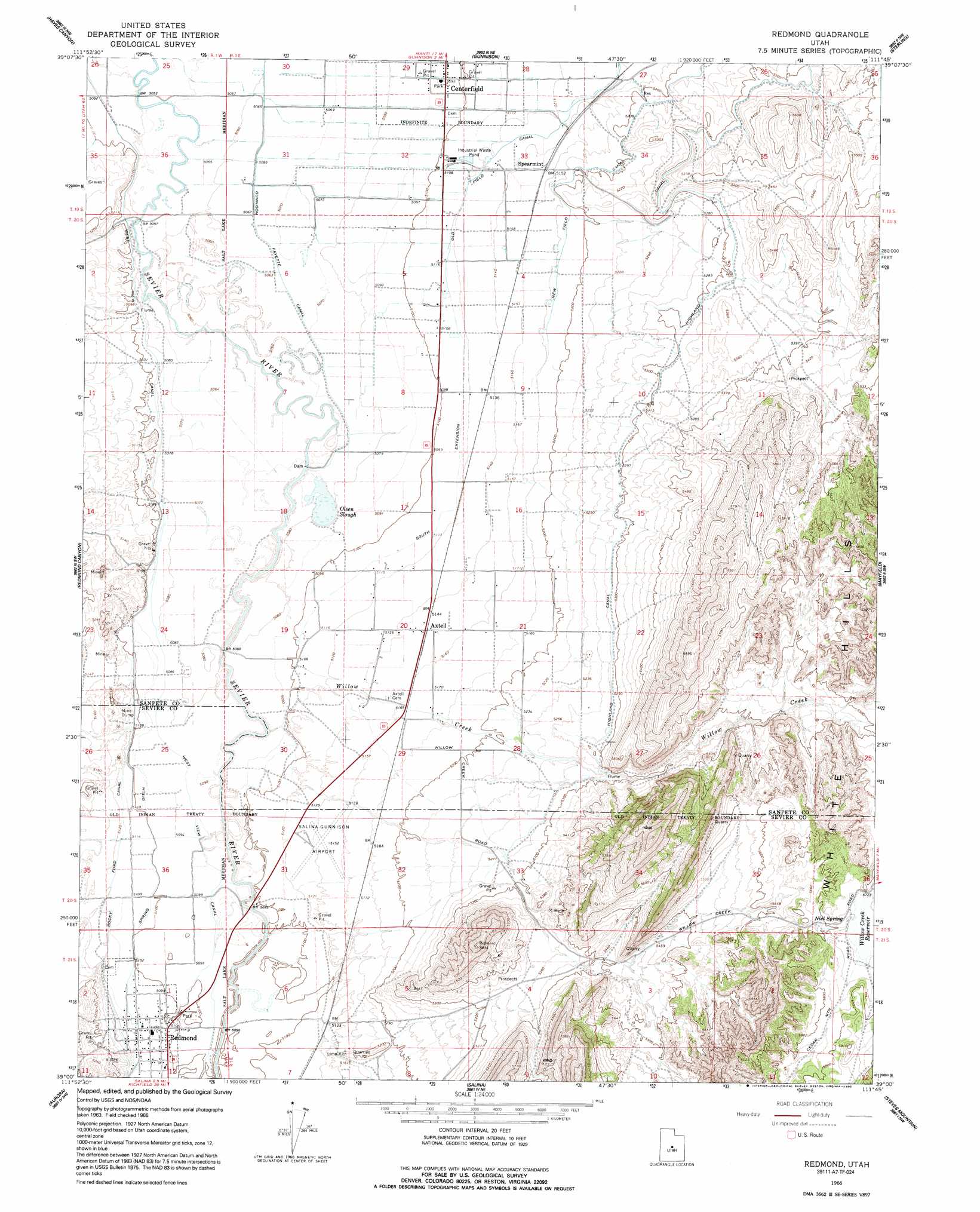
USGS Topo Quad 39111a7 - 1:24,000 scale
| Topo Map Name: | Redmond |
| USGS Topo Quad ID: | 39111a7 |
| Print Size: | ca. 21 1/4" wide x 27" high |
| Southeast Coordinates: | 39° N latitude / 111.75° W longitude |
| Map Center Coordinates: | 39.0625° N latitude / 111.8125° W longitude |
| U.S. State: | UT |
| Filename: | o39111a7.jpg |
| Download Map JPG Image: | Redmond topo map 1:24,000 scale |
| Map Type: | Topographic |
| Topo Series: | 7.5´ |
| Map Scale: | 1:24,000 |
| Source of Map Images: | United States Geological Survey (USGS) |
| Alternate Map Versions: |
Redmond UT 1966, updated 1967 Download PDF Buy paper map Redmond UT 1966, updated 1992 Download PDF Buy paper map Redmond UT 2011 Download PDF Buy paper map Redmond UT 2014 Download PDF Buy paper map |
1:24,000 Topo Quads surrounding Redmond
Scipio North |
Hells Kitchen Canyon Sw |
Hells Kitchen Canyon Se |
Manti |
Ephraim |
Scipio South |
Hayes Canyon |
Gunnison |
Sterling |
Black Mountain |
Scipio Lake |
Redmond Canyon |
Redmond |
Mayfield |
Woods Lake |
Beehive Peak |
Aurora |
Salina |
Steves Mountain |
Water Hollow Ridge |
Richfield |
Sigurd |
Rex Reservoir |
Gooseberry Creek |
Yogo Creek |
> Back to 39111a1 at 1:100,000 scale
> Back to 39110a1 at 1:250,000 scale
> Back to U.S. Topo Maps home
Redmond topo map: Gazetteer
Redmond: Airports
Salina-Gunnison Airport elevation 1569m 5147′Redmond: Canals
Highland Canal elevation 1617m 5305′Old Field Canal elevation 1562m 5124′
South Extension Old Field Canal elevation 1561m 5121′
Spring Ditch elevation 1554m 5098′
West View Canal elevation 1550m 5085′
Redmond: Dams
Willow Creek Dam elevation 1745m 5725′Redmond: Lakes
Olsen Slough elevation 1545m 5068′Redmond: Populated Places
Axtell elevation 1570m 5150′Redmond elevation 1556m 5104′
Spearmint elevation 1572m 5157′
Redmond: Post Offices
Axtell Post Office elevation 1570m 5150′Redmond: Reservoirs
Willow Creek Reservoir elevation 1745m 5725′Willow Creek Reservoir elevation 1745m 5725′
Redmond: Springs
Niel Spring elevation 1730m 5675′Redmond: Streams
Willow Creek elevation 1548m 5078′Redmond digital topo map on disk
Buy this Redmond topo map showing relief, roads, GPS coordinates and other geographical features, as a high-resolution digital map file on DVD: