Castle Dale Topo Map Utah
To zoom in, hover over the map of Castle Dale
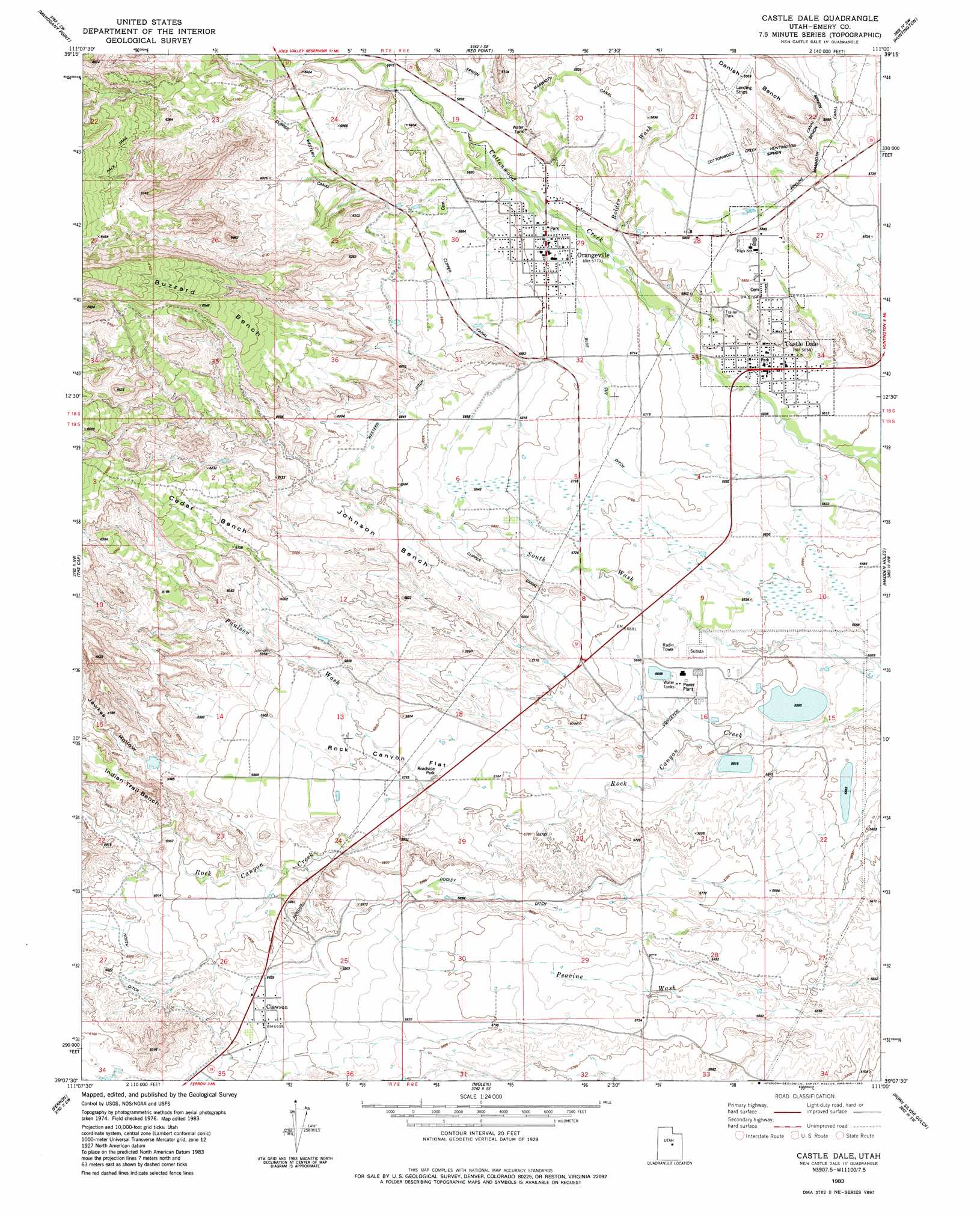
USGS Topo Quad 39111b1 - 1:24,000 scale
| Topo Map Name: | Castle Dale |
| USGS Topo Quad ID: | 39111b1 |
| Print Size: | ca. 21 1/4" wide x 27" high |
| Southeast Coordinates: | 39.125° N latitude / 111° W longitude |
| Map Center Coordinates: | 39.1875° N latitude / 111.0625° W longitude |
| U.S. State: | UT |
| Filename: | o39111b1.jpg |
| Download Map JPG Image: | Castle Dale topo map 1:24,000 scale |
| Map Type: | Topographic |
| Topo Series: | 7.5´ |
| Map Scale: | 1:24,000 |
| Source of Map Images: | United States Geological Survey (USGS) |
| Alternate Map Versions: |
Castle Dale UT 1983, updated 1983 Download PDF Buy paper map Castle Dale UT 2011 Download PDF Buy paper map Castle Dale UT 2014 Download PDF Buy paper map |
1:24,000 Topo Quads surrounding Castle Dale
South Tent Mountain |
Rilda Canyon |
Hiawatha |
Poison Spring Bench |
Elmo |
Joes Valley Reservoir |
Mahogany Point |
Red Point |
Huntington |
Cleveland |
Ferron Canyon |
The Cap |
Castle Dale |
Hadden Holes |
Buckhorn Reservoir |
Flagstaff Peak |
Ferron |
Molen |
Horn Silver Gulch |
Sids Mountain |
Emery West |
Emery East |
Short Canyon |
Sid And Charley |
The Blocks |
> Back to 39111a1 at 1:100,000 scale
> Back to 39110a1 at 1:250,000 scale
> Back to U.S. Topo Maps home
Castle Dale topo map: Gazetteer
Castle Dale: Benches
Buzzard Bench elevation 1965m 6446′Cedar Bench elevation 1968m 6456′
Indian Trail Bench elevation 1891m 6204′
Johnson Bench elevation 1809m 5935′
Castle Dale: Canals
Blue Cut Ditch elevation 1766m 5793′Clipper Canal elevation 1784m 5853′
Dooley Ditch elevation 1785m 5856′
North Ditch elevation 1822m 5977′
Western Ditch elevation 1817m 5961′
Castle Dale: Dams
Emery Dam elevation 1710m 5610′Emery Plant Dam elevation 1699m 5574′
Castle Dale: Flats
Rock Canyon Flat elevation 1777m 5830′Castle Dale: Parks
Wilberg Memorial elevation 1725m 5659′Castle Dale: Populated Places
Castle Dale elevation 1730m 5675′Clawson elevation 1811m 5941′
Orangeville elevation 1761m 5777′
Castle Dale: Reservoirs
Emery Plant Reservoir elevation 1699m 5574′Utah Power and Light Ash Reservoir elevation 1710m 5610′
Castle Dale: Valleys
Bolden Wash elevation 1757m 5764′Grimes Wash elevation 1806m 5925′
Jewkes Hollow elevation 1813m 5948′
Paulson Wash elevation 1837m 6026′
Castle Dale digital topo map on disk
Buy this Castle Dale topo map showing relief, roads, GPS coordinates and other geographical features, as a high-resolution digital map file on DVD: