Black Mountain Topo Map Utah
To zoom in, hover over the map of Black Mountain
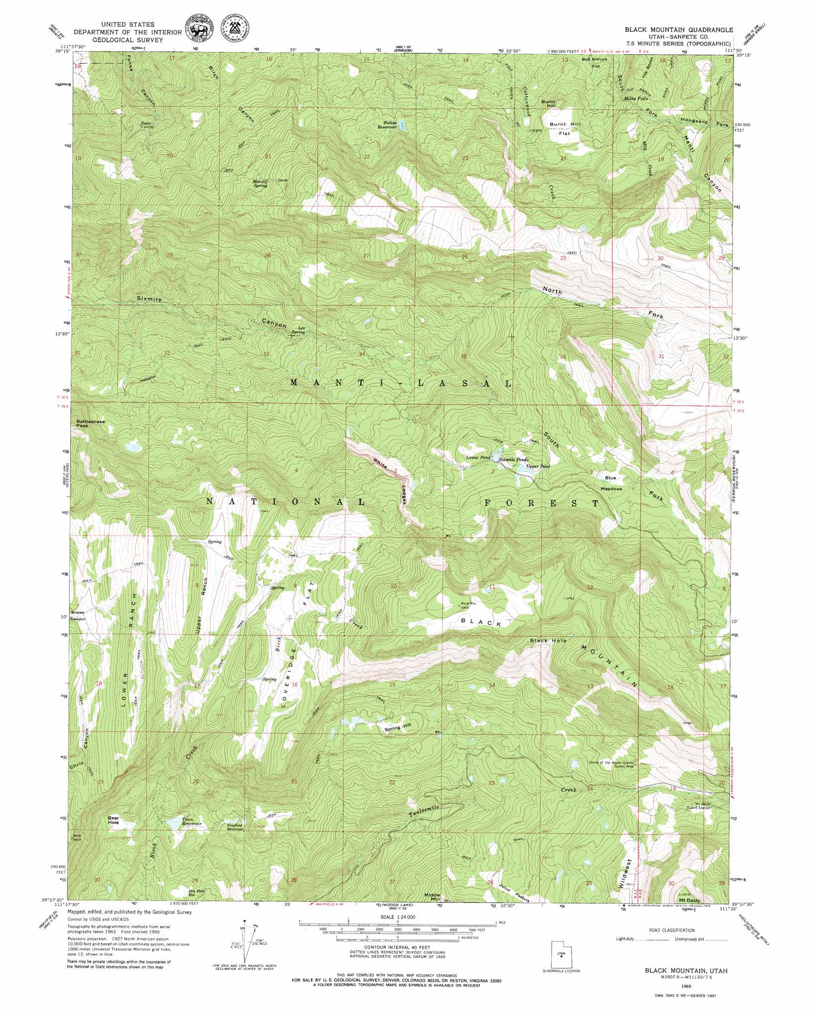
USGS Topo Quad 39111b5 - 1:24,000 scale
| Topo Map Name: | Black Mountain |
| USGS Topo Quad ID: | 39111b5 |
| Print Size: | ca. 21 1/4" wide x 27" high |
| Southeast Coordinates: | 39.125° N latitude / 111.5° W longitude |
| Map Center Coordinates: | 39.1875° N latitude / 111.5625° W longitude |
| U.S. State: | UT |
| Filename: | o39111b5.jpg |
| Download Map JPG Image: | Black Mountain topo map 1:24,000 scale |
| Map Type: | Topographic |
| Topo Series: | 7.5´ |
| Map Scale: | 1:24,000 |
| Source of Map Images: | United States Geological Survey (USGS) |
| Alternate Map Versions: |
Black Mountain UT 1965, updated 1968 Download PDF Buy paper map Black Mountain UT 1965, updated 1979 Download PDF Buy paper map Black Mountain UT 2001, updated 2004 Download PDF Buy paper map Black Mountain UT 2011 Download PDF Buy paper map Black Mountain UT 2014 Download PDF Buy paper map |
| FStopo: | US Forest Service topo Black Mountain is available: Download FStopo PDF Download FStopo TIF |
1:24,000 Topo Quads surrounding Black Mountain
Chriss Canyon |
Wales |
Chester |
Spring City |
South Tent Mountain |
Hells Kitchen Canyon Se |
Manti |
Ephraim |
Danish Knoll |
Joes Valley Reservoir |
Gunnison |
Sterling |
Black Mountain |
Ferron Reservoir |
Ferron Canyon |
Redmond |
Mayfield |
Woods Lake |
Heliotrope Mountain |
Flagstaff Peak |
Salina |
Steves Mountain |
Water Hollow Ridge |
Acord Lakes |
Emery West |
> Back to 39111a1 at 1:100,000 scale
> Back to 39110a1 at 1:250,000 scale
> Back to U.S. Topo Maps home
Black Mountain topo map: Gazetteer
Black Mountain: Areas
Wildwest elevation 2919m 9576′Black Mountain: Basins
Bear Hole elevation 2376m 7795′Black Hole elevation 3031m 9944′
Black Mountain: Cliffs
White Ledges elevation 2701m 8861′Black Mountain: Dams
Town Reservoir Dam elevation 2354m 7723′Black Mountain: Falls
Milky Falls elevation 2578m 8458′Black Mountain: Flats
Blue Meadows elevation 2758m 9048′Bub Arthurs Flat elevation 2616m 8582′
Burnt Hill Flat elevation 2605m 8546′
Julius Pasture elevation 2662m 8733′
Loveridge Flat elevation 2861m 9386′
Black Mountain: Lakes
Lower Pond elevation 2702m 8864′Sixmile Ponds elevation 2703m 8868′
Upper Pond elevation 2740m 8989′
Black Mountain: Parks
Peacock Wildlife Management Area elevation 1971m 6466′Black Mountain: Reservoirs
Dry Hole Reservoir elevation 2264m 7427′Newfield Reservoir elevation 2448m 8031′
Patton Reservoir elevation 2514m 8248′
Town Reservoir elevation 2361m 7746′
Black Mountain: Slopes
Lower Ranch elevation 2807m 9209′Upper Ranch elevation 2801m 9189′
Black Mountain: Springs
Leo Spring elevation 2278m 7473′Metcalf Spring elevation 2706m 8877′
Black Mountain: Streams
Hougaard Fork elevation 2674m 8772′Milk Creek elevation 2642m 8667′
Black Mountain: Summits
Black Mountain elevation 3129m 10265′Burnt Hill elevation 2629m 8625′
Middle Mountain elevation 2684m 8805′
Mount Baldy elevation 3328m 10918′
Spring Hill elevation 2770m 9087′
Black Mountain: Trails
Harmon Trail elevation 2249m 7378′Black Mountain: Valleys
North Fork Sixmile Canyon elevation 2399m 7870′South Fork Sixmile Canyon elevation 2397m 7864′
Black Mountain digital topo map on disk
Buy this Black Mountain topo map showing relief, roads, GPS coordinates and other geographical features, as a high-resolution digital map file on DVD: