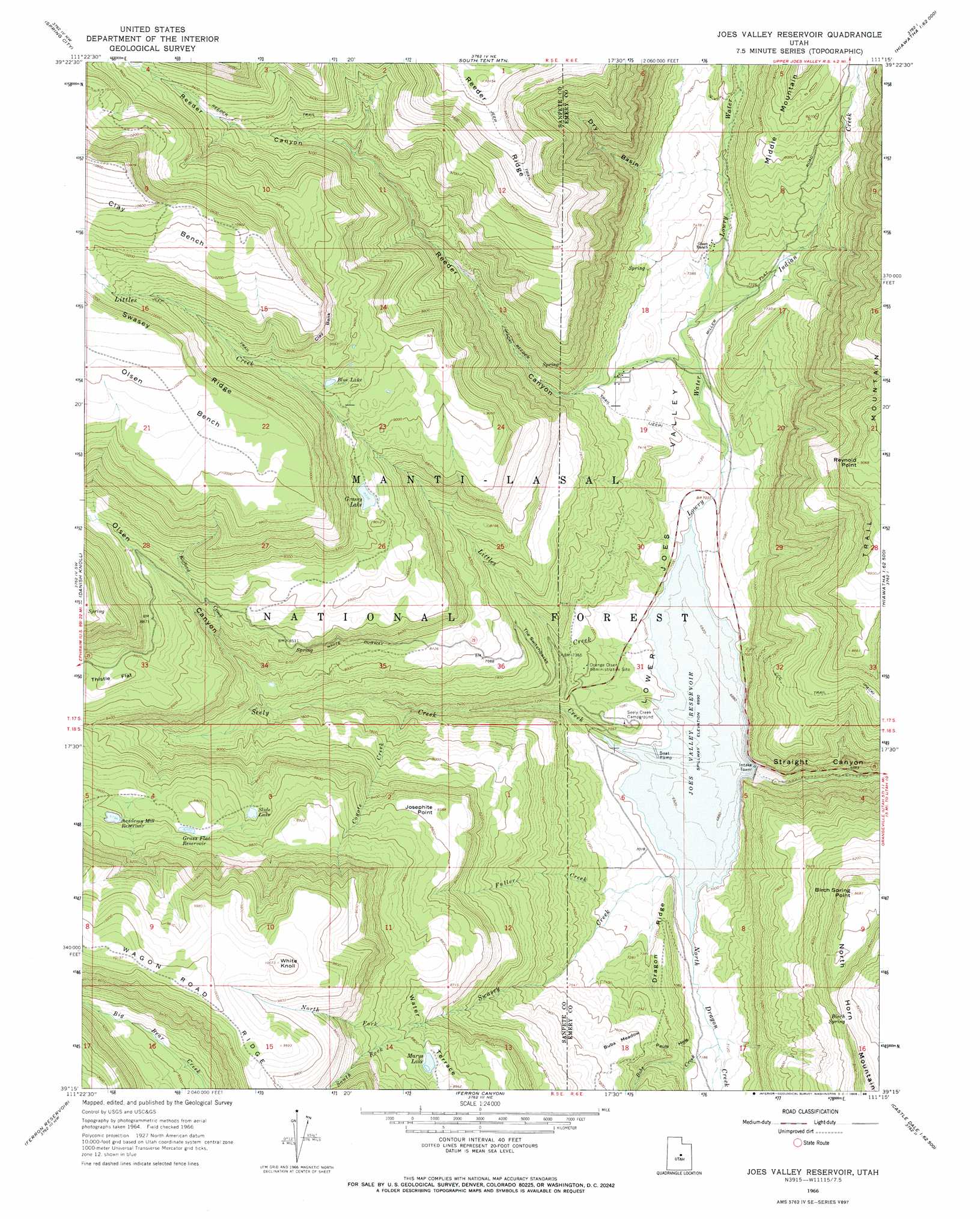
Joes Valley Reservoir Topo Map Utah
To zoom in, hover over the map of Joes Valley Reservoir
USGS Topo Quad 39111c3 - 1:24,000 scale
| Topo Map Name: | Joes Valley Reservoir |
| USGS Topo Quad ID: | 39111c3 |
| Print Size: | ca. 21 1/4" wide x 27" high |
| Southeast Coordinates: | 39.25° N latitude / 111.25° W longitude |
| Map Center Coordinates: | 39.3125° N latitude / 111.3125° W longitude |
| U.S. State: | UT |
| Filename: | o39111c3.jpg |
| Download Map JPG Image: | Joes Valley Reservoir topo map 1:24,000 scale |
| Map Type: | Topographic |
| Topo Series: | 7.5´ |
| Map Scale: | 1:24,000 |
| Source of Map Images: | United States Geological Survey (USGS) |
| Alternate Map Versions: |
Joes Valley Reservoir UT 1966, updated 1968 Download PDF Buy paper map Joes Valley Reservoir UT 1966, updated 1988 Download PDF Buy paper map Joes Valley Reservoir UT 2001, updated 2004 Download PDF Buy paper map Joes Valley Reservoir UT 2011 Download PDF Buy paper map Joes Valley Reservoir UT 2014 Download PDF Buy paper map |
| FStopo: | US Forest Service topo Joes Valley Reservoir is available: Download FStopo PDF Download FStopo TIF |
1:24,000 Topo Quads surrounding Joes Valley Reservoir
Moroni |
Mount Pleasant |
Huntington Reservoir |
Candland Mountain |
Wattis |
Chester |
Spring City |
South Tent Mountain |
Rilda Canyon |
Hiawatha |
Ephraim |
Danish Knoll |
Joes Valley Reservoir |
Mahogany Point |
Red Point |
Black Mountain |
Ferron Reservoir |
Ferron Canyon |
The Cap |
Castle Dale |
Woods Lake |
Heliotrope Mountain |
Flagstaff Peak |
Ferron |
Molen |
> Back to 39111a1 at 1:100,000 scale
> Back to 39110a1 at 1:250,000 scale
> Back to U.S. Topo Maps home
Joes Valley Reservoir topo map: Gazetteer
Joes Valley Reservoir: Basins
Pauls Hole elevation 2222m 7290′Joes Valley Reservoir: Benches
Clay Bench elevation 3200m 10498′Olsen Bench elevation 3117m 10226′
Joes Valley Reservoir: Cliffs
Clay Bank elevation 2953m 9688′Joes Valley Reservoir: Dams
Academy Mill Reservoir Dam elevation 2670m 8759′Grassy Lake Dam elevation 2717m 8914′
Joes Valley Dam elevation 2132m 6994′
Joes Valley Reservoir: Flats
Bubs Meadow elevation 2342m 7683′Thistle Flat elevation 2678m 8786′
Joes Valley Reservoir: Lakes
Blue Lake elevation 2825m 9268′Marys Lake elevation 2692m 8832′
Slide Lake elevation 2618m 8589′
Joes Valley Reservoir: Plains
Wasatch Plateau elevation 2690m 8825′Joes Valley Reservoir: Reservoirs
Academy Mill Reservoir elevation 2683m 8802′Grass Flat Reservoir elevation 2683m 8802′
Grassy Lake elevation 2723m 8933′
Joes Valley Reservoir elevation 2113m 6932′
Joes Valley Reservoir: Ridges
Dragon Ridge elevation 2222m 7290′Reeder Ridge elevation 3041m 9977′
Swasey Ridge elevation 3104m 10183′
Wagon Road Ridge elevation 3039m 9970′
Joes Valley Reservoir: Slopes
The Switchbacks elevation 2369m 7772′Joes Valley Reservoir: Springs
Birch Spring elevation 2542m 8339′Joes Valley Reservoir: Streams
Bubs Creek elevation 2165m 7103′Coyote Creek elevation 2253m 7391′
Fuller Creek elevation 2157m 7076′
Indian Creek elevation 2192m 7191′
Kofford Creek elevation 2484m 8149′
Littles Creek elevation 2132m 6994′
Lowry Water elevation 2137m 7011′
North Dragon Creek elevation 2136m 7007′
North Fork Swasey Creek elevation 2632m 8635′
Seely Creek elevation 2132m 6994′
South Fork Swasey Creek elevation 2628m 8622′
Swasey Creek elevation 2132m 6994′
Joes Valley Reservoir: Summits
Birch Spring Point elevation 2648m 8687′Josephite Point elevation 2613m 8572′
Reynold Point elevation 2762m 9061′
White Knoll elevation 3070m 10072′
Joes Valley Reservoir: Trails
Reeder Trail elevation 2575m 8448′Joes Valley Reservoir: Valleys
Dry Basin elevation 2258m 7408′Little Canyon elevation 2133m 6998′
Lower Joes Valley elevation 2136m 7007′
Olsen Canyon elevation 2340m 7677′
Reeder Canyon elevation 2252m 7388′
Joes Valley Reservoir digital topo map on disk
Buy this Joes Valley Reservoir topo map showing relief, roads, GPS coordinates and other geographical features, as a high-resolution digital map file on DVD: