Hiawatha Topo Map Utah
To zoom in, hover over the map of Hiawatha
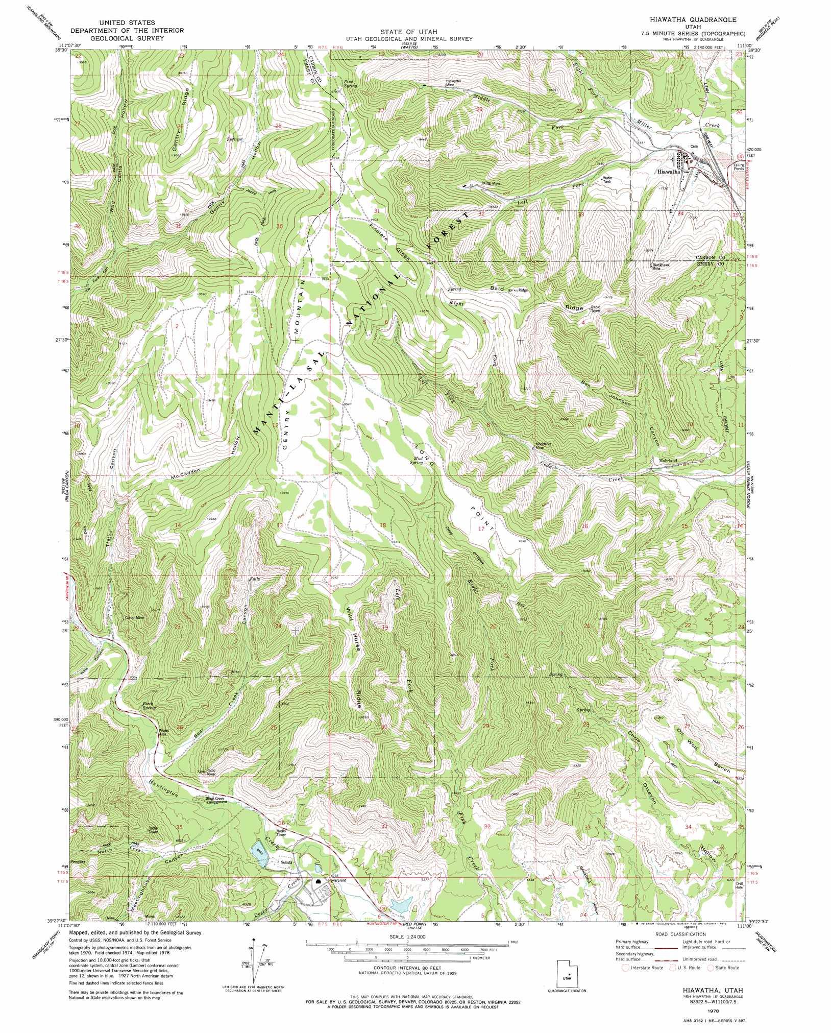
USGS Topo Quad 39111d1 - 1:24,000 scale
| Topo Map Name: | Hiawatha |
| USGS Topo Quad ID: | 39111d1 |
| Print Size: | ca. 21 1/4" wide x 27" high |
| Southeast Coordinates: | 39.375° N latitude / 111° W longitude |
| Map Center Coordinates: | 39.4375° N latitude / 111.0625° W longitude |
| U.S. State: | UT |
| Filename: | o39111d1.jpg |
| Download Map JPG Image: | Hiawatha topo map 1:24,000 scale |
| Map Type: | Topographic |
| Topo Series: | 7.5´ |
| Map Scale: | 1:24,000 |
| Source of Map Images: | United States Geological Survey (USGS) |
| Alternate Map Versions: |
Hiawatha UT 1978, updated 1979 Download PDF Buy paper map Hiawatha UT 2001, updated 2004 Download PDF Buy paper map Hiawatha UT 2011 Download PDF Buy paper map Hiawatha UT 2014 Download PDF Buy paper map |
| FStopo: | US Forest Service topo Hiawatha is available: Download FStopo PDF Download FStopo TIF |
1:24,000 Topo Quads surrounding Hiawatha
Fairview Lakes |
Scofield |
Jump Creek |
Standardville |
Helper |
Huntington Reservoir |
Candland Mountain |
Wattis |
Pinnacle Peak |
Price |
South Tent Mountain |
Rilda Canyon |
Hiawatha |
Poison Spring Bench |
Elmo |
Joes Valley Reservoir |
Mahogany Point |
Red Point |
Huntington |
Cleveland |
Ferron Canyon |
The Cap |
Castle Dale |
Hadden Holes |
Buckhorn Reservoir |
> Back to 39111a1 at 1:100,000 scale
> Back to 39110a1 at 1:250,000 scale
> Back to U.S. Topo Maps home
Hiawatha topo map: Gazetteer
Hiawatha: Benches
Oil Well Bench elevation 2083m 6833′Hiawatha: Capes
Long Point elevation 2844m 9330′Hiawatha: Dams
Huntington Dam elevation 1952m 6404′Hiawatha: Flats
Fiddlers Green elevation 2938m 9639′Hiawatha: Mines
Blackhawk Mine elevation 2436m 7992′Co-op Mine elevation 2249m 7378′
Hiawatha Mine elevation 2482m 8143′
King Mine elevation 2489m 8166′
King Number Four and Number Five Mine elevation 2526m 8287′
King Number Two Mine elevation 2357m 7732′
Mohrland Mine elevation 2381m 7811′
Hiawatha: Populated Places
Hiawatha elevation 2214m 7263′Mohrland elevation 2190m 7185′
Hiawatha: Reservoirs
Huntington Reservoir elevation 1952m 6404′Hiawatha: Ridges
Bald Ridge elevation 2858m 9376′Wild Horse Ridge elevation 2698m 8851′
Hiawatha: Springs
Birch Spring elevation 2090m 6856′Mud Spring elevation 2842m 9324′
Pine Spring elevation 2980m 9776′
Hiawatha: Streams
Deer Creek elevation 1940m 6364′Left Fork Cedar Creek elevation 2463m 8080′
Left Fork Fish Creek elevation 2073m 6801′
Left Fork Miller Creek elevation 2186m 7171′
Middle Fork Miller Creek elevation 2236m 7335′
Right Fork Cedar Creek elevation 2454m 8051′
Right Fork Fish Creek elevation 2072m 6797′
Right Fork Miller Creek elevation 2236m 7335′
Hiawatha: Trails
Chris Otteson Trail elevation 2783m 9130′Hiawatha: Valleys
Bear Creek Canyon elevation 2051m 6729′Ben Johnson Canyon elevation 2188m 7178′
Gentry Hollow elevation 2414m 7919′
Huntington Canyon elevation 2451m 8041′
Jacks Hole elevation 2677m 8782′
McCadden Hollow elevation 2407m 7896′
Meetinghouse Canyon elevation 1996m 6548′
North Fork Meetinghouse Canyon elevation 2084m 6837′
Rilda Canyon elevation 2110m 6922′
Trail Canyon elevation 2118m 6948′
Wild Cattle Hollow elevation 2423m 7949′
Hiawatha digital topo map on disk
Buy this Hiawatha topo map showing relief, roads, GPS coordinates and other geographical features, as a high-resolution digital map file on DVD: