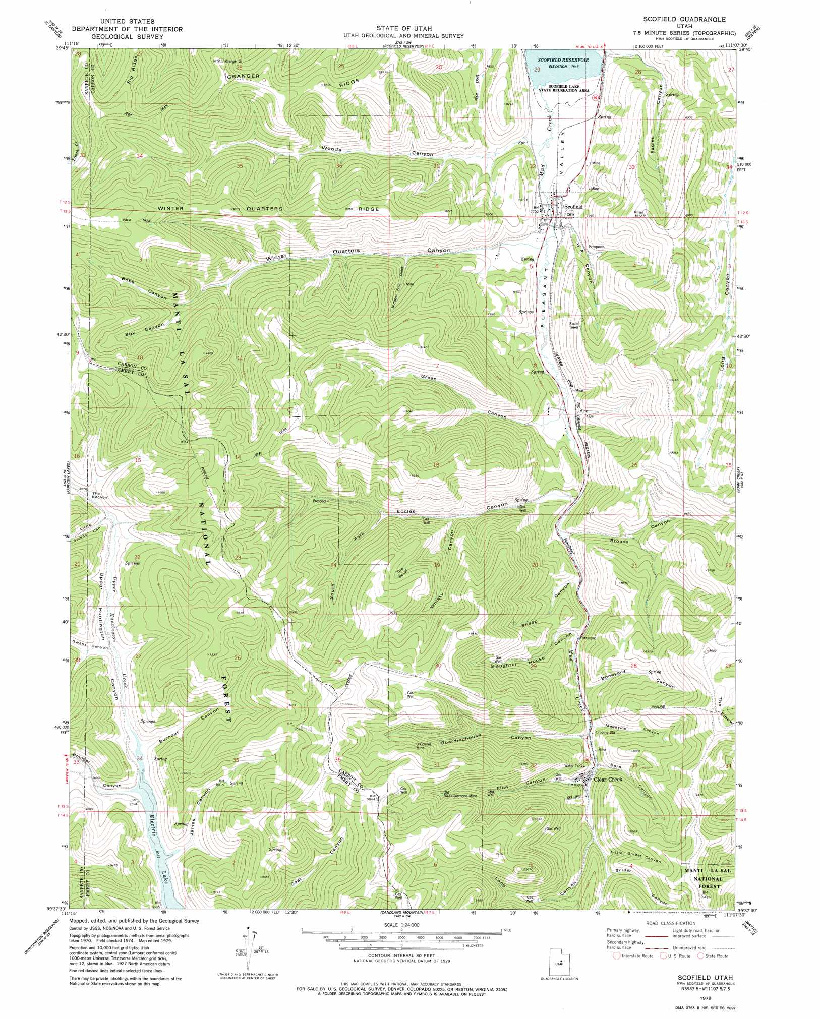
Scofield Topo Map Utah
To zoom in, hover over the map of Scofield
USGS Topo Quad 39111f2 - 1:24,000 scale
| Topo Map Name: | Scofield |
| USGS Topo Quad ID: | 39111f2 |
| Print Size: | ca. 21 1/4" wide x 27" high |
| Southeast Coordinates: | 39.625° N latitude / 111.125° W longitude |
| Map Center Coordinates: | 39.6875° N latitude / 111.1875° W longitude |
| U.S. State: | UT |
| Filename: | o39111f2.jpg |
| Download Map JPG Image: | Scofield topo map 1:24,000 scale |
| Map Type: | Topographic |
| Topo Series: | 7.5´ |
| Map Scale: | 1:24,000 |
| Source of Map Images: | United States Geological Survey (USGS) |
| Alternate Map Versions: |
Scofield UT 1979, updated 1983 Download PDF Buy paper map Scofield UT 2001, updated 2004 Download PDF Buy paper map Scofield UT 2011 Download PDF Buy paper map Scofield UT 2014 Download PDF Buy paper map |
| FStopo: | US Forest Service topo Scofield is available: Download FStopo PDF Download FStopo TIF |
1:24,000 Topo Quads surrounding Scofield
Thistle |
Mill Fork |
Tucker |
Soldier Summit |
Flat Ridge |
Indianola |
C Canyon |
Scofield Reservoir |
Colton |
Kyune |
Fairview |
Fairview Lakes |
Scofield |
Jump Creek |
Standardville |
Mount Pleasant |
Huntington Reservoir |
Candland Mountain |
Wattis |
Pinnacle Peak |
Spring City |
South Tent Mountain |
Rilda Canyon |
Hiawatha |
Poison Spring Bench |
> Back to 39111e1 at 1:100,000 scale
> Back to 39110a1 at 1:250,000 scale
> Back to U.S. Topo Maps home
Scofield topo map: Gazetteer
Scofield: Basins
The Bowl elevation 2735m 8973′The Kitchen elevation 2750m 9022′
Scofield: Mines
Belina Mine elevation 2728m 8950′Clear Creek Mines Number 3 elevation 2654m 8707′
Clear Creek Mines Number 4 elevation 2678m 8786′
Gibson Mine elevation 2398m 7867′
O'Conner Mine elevation 2863m 9393′
Old Black Diamond Mine elevation 2789m 9150′
Skyline Mine elevation 2610m 8562′
Utah Mine (historical) elevation 2425m 7956′
Scofield: Populated Places
Clear Creek elevation 2532m 8307′Scofield elevation 2351m 7713′
Winter Quarters elevation 2464m 8083′
Scofield: Ridges
Granger Ridge elevation 2704m 8871′Scofield: Springs
Sulphur Spring elevation 2462m 8077′Sulphur Springs elevation 2341m 7680′
Scofield: Streams
Mud Creek elevation 2323m 7621′Upper Huntington Creek elevation 2615m 8579′
Scofield: Summits
The Elbow elevation 2907m 9537′Scofield: Valleys
Barn Canyon elevation 2522m 8274′Boardinghouse Canyon elevation 2518m 8261′
Bobs Canyon elevation 2610m 8562′
Boneyard Canyon elevation 2490m 8169′
Box Canyon elevation 2610m 8562′
Broads Canyon elevation 2424m 7952′
Burnout Canyon elevation 2636m 8648′
Eccles Canyon elevation 2412m 7913′
Finn Canyon elevation 2536m 8320′
Flat Canyon elevation 2615m 8579′
Green Canyon elevation 2393m 7851′
James Canyon elevation 2615m 8579′
Little Snider Canyon elevation 2586m 8484′
Little Swens Canyon elevation 2676m 8779′
Long Canyon elevation 2588m 8490′
Magazine Canyon elevation 2520m 8267′
Number Four Gulch elevation 2430m 7972′
Pleasant Valley elevation 2395m 7857′
Sheep Canyon elevation 2441m 8008′
Slaughter House Canyon elevation 2502m 8208′
Snider Canyon elevation 2604m 8543′
South Fork Eccles Canyon elevation 2558m 8392′
Swens Canyon elevation 2635m 8645′
U P Canyon elevation 2355m 7726′
Upper Huntington Canyon elevation 2615m 8579′
Whiskey Canyon elevation 2499m 8198′
Winter Quarters Canyon elevation 2473m 8113′
Woods Canyon elevation 2352m 7716′
Scofield digital topo map on disk
Buy this Scofield topo map showing relief, roads, GPS coordinates and other geographical features, as a high-resolution digital map file on DVD: