Nebo Basin Topo Map Utah
To zoom in, hover over the map of Nebo Basin
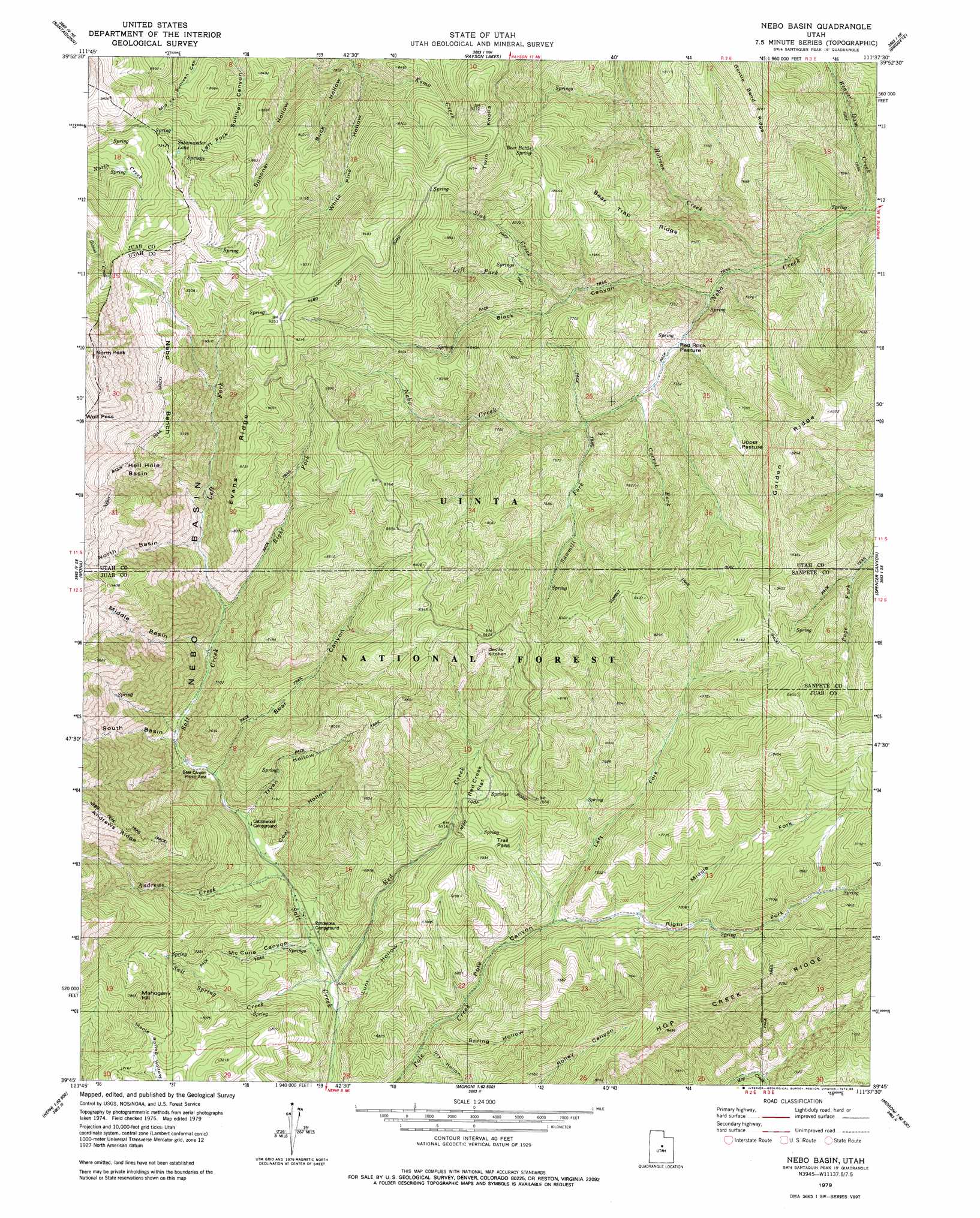
USGS Topo Quad 39111g6 - 1:24,000 scale
| Topo Map Name: | Nebo Basin |
| USGS Topo Quad ID: | 39111g6 |
| Print Size: | ca. 21 1/4" wide x 27" high |
| Southeast Coordinates: | 39.75° N latitude / 111.625° W longitude |
| Map Center Coordinates: | 39.8125° N latitude / 111.6875° W longitude |
| U.S. State: | UT |
| Filename: | o39111g6.jpg |
| Download Map JPG Image: | Nebo Basin topo map 1:24,000 scale |
| Map Type: | Topographic |
| Topo Series: | 7.5´ |
| Map Scale: | 1:24,000 |
| Source of Map Images: | United States Geological Survey (USGS) |
| Alternate Map Versions: |
Nebo Basin UT 1979, updated 1985 Download PDF Buy paper map Nebo Basin UT 1998, updated 2002 Download PDF Buy paper map Nebo Basin UT 2011 Download PDF Buy paper map Nebo Basin UT 2014 Download PDF Buy paper map |
| FStopo: | US Forest Service topo Nebo Basin is available: Download FStopo PDF Download FStopo TIF |
1:24,000 Topo Quads surrounding Nebo Basin
Goshen Valley North |
West Mountain |
Spanish Fork |
Spanish Fork Peak |
Billies Mountain |
Goshen |
Santaquin |
Payson Lakes |
Birdseye |
Thistle |
Slate Jack Canyon |
Mona |
Nebo Basin |
Spencer Canyon |
Indianola |
Sugarloaf |
Nephi |
Fountain Green North |
Big Hollow |
Fairview |
Juab |
Levan |
Fountain Green South |
Moroni |
Mount Pleasant |
> Back to 39111e1 at 1:100,000 scale
> Back to 39110a1 at 1:250,000 scale
> Back to U.S. Topo Maps home
Nebo Basin topo map: Gazetteer
Nebo Basin: Areas
Devils Kitchen elevation 2497m 8192′Nebo Basin: Basins
Hell Hole Basin elevation 3057m 10029′Middle Basin elevation 2776m 9107′
Nebo Basin elevation 2355m 7726′
Nebo Basin: Benches
Nebo Bench elevation 2826m 9271′Nebo Basin: Flats
Red Creek Flat elevation 2208m 7244′Red Rock Pasture elevation 2037m 6683′
Upper Pasture elevation 2212m 7257′
Nebo Basin: Gaps
Trail Pass elevation 2186m 7171′Nebo Basin: Lakes
Salamander Lake elevation 2816m 9238′Nebo Basin: Ridges
Andrews Ridge elevation 2687m 8815′Bear Trap Ridge elevation 2330m 7644′
Evans Ridge elevation 2656m 8713′
Golden Ridge elevation 2511m 8238′
Hop Creek Ridge elevation 2525m 8284′
Nebo Basin: Springs
Beer Bottle Spring elevation 2563m 8408′Nebo Basin: Streams
Andrews Creek elevation 1963m 6440′Beaver Dam Creek elevation 1911m 6269′
Corral Fork elevation 2073m 6801′
Holman Creek elevation 1951m 6400′
Kemo Creek elevation 2376m 7795′
Left Fork Pole Creek elevation 2024m 6640′
Left Fork Salt Creek elevation 2164m 7099′
Left Fork Slab Creek elevation 2283m 7490′
Middle Fork Pole Creek elevation 2091m 6860′
Red Creek elevation 1888m 6194′
Right Fork Pole Creek elevation 2094m 6870′
Right Fork Salt Creek elevation 2164m 7099′
Salt Spring Creek elevation 1888m 6194′
Sawmill Fork elevation 2122m 6961′
Slab Creek elevation 2227m 7306′
Nebo Basin: Summits
Mahogany Hill elevation 2396m 7860′North Peak elevation 3400m 11154′
Twin Knolls elevation 2823m 9261′
Nebo Basin: Trails
Nebo Basin Trail elevation 2826m 9271′Nebo Peak Trail elevation 2652m 8700′
Summit Trail elevation 2514m 8248′
Nebo Basin: Valleys
Bear Canyon elevation 2022m 6633′Black Canyon elevation 2005m 6578′
Buck Hollow elevation 2368m 7769′
Cow Hollow elevation 1977m 6486′
Dry Hollow elevation 1922m 6305′
Lunt Hollow elevation 1879m 6164′
McCune Canyon elevation 1912m 6272′
Pole Canyon elevation 1892m 6207′
Spooner Hollow elevation 2339m 7673′
Spring Hollow elevation 1952m 6404′
Tryan Hollow elevation 2000m 6561′
White Pine Hollow elevation 2376m 7795′
Nebo Basin digital topo map on disk
Buy this Nebo Basin topo map showing relief, roads, GPS coordinates and other geographical features, as a high-resolution digital map file on DVD: