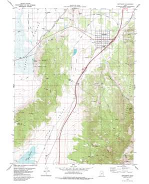
Santaquin Topo Map Utah
To zoom in, hover over the map of Santaquin
USGS Topo Quad 39111h7 - 1:24,000 scale
| Topo Map Name: | Santaquin |
| USGS Topo Quad ID: | 39111h7 |
| Print Size: | ca. 21 1/4" wide x 27" high |
| Southeast Coordinates: | 39.875° N latitude / 111.75° W longitude |
| Map Center Coordinates: | 39.9375° N latitude / 111.8125° W longitude |
| U.S. State: | UT |
| Filename: | o39111h7.jpg |
| Download Map JPG Image: | Santaquin topo map 1:24,000 scale |
| Map Type: | Topographic |
| Topo Series: | 7.5´ |
| Map Scale: | 1:24,000 |
| Source of Map Images: | United States Geological Survey (USGS) |
| Alternate Map Versions: |
Santaquin UT 1979, updated 1984 Download PDF Buy paper map Santaquin UT 1998, updated 2002 Download PDF Buy paper map Santaquin UT 2011 Download PDF Buy paper map Santaquin UT 2014 Download PDF Buy paper map |
| FStopo: | US Forest Service topo Santaquin is available: Download FStopo PDF Download FStopo TIF |
1:24,000 Topo Quads surrounding Santaquin
> Back to 39111e1 at 1:100,000 scale
> Back to 39110a1 at 1:250,000 scale
> Back to U.S. Topo Maps home
Santaquin topo map: Gazetteer
Santaquin: Canals
East Warm Creek Ditch elevation 1383m 4537′Warm Springs Ditch elevation 1382m 4534′
Santaquin: Dams
Ewell Dam elevation 1456m 4776′Mona Dam elevation 1488m 4881′
Santaquin Debris Basin Dam elevation 1582m 5190′
Summit Creek Number Two Dam elevation 1507m 4944′
Santaquin: Flats
West Park elevation 1522m 4993′Santaquin: Populated Places
Genola elevation 1402m 4599′Rocky Ridge elevation 1521m 4990′
Santaquin elevation 1519m 4983′
Townsend elevation 1431m 4694′
Santaquin: Post Offices
Santaquin Post Office elevation 1517m 4977′Santaquin: Reservoirs
Ewell Regulating Reservoir elevation 1456m 4776′Santaquin Debris Basin Reservoir elevation 1582m 5190′
Summit Creek Number Two Reservoir elevation 1507m 4944′
Santaquin: Springs
Warm Springs elevation 1391m 4563′Santaquin: Streams
Mendenhall Creek elevation 1570m 5150′Summit Creek elevation 1585m 5200′
Santaquin: Summits
Bald Mountain elevation 3317m 10882′Goshen Hill elevation 1551m 5088′
Warm Springs Mountain elevation 1687m 5534′
Santaquin: Valleys
Black Hollow elevation 1415m 4642′Cedar Hollow elevation 1509m 4950′
Little Valley elevation 1415m 4642′
Pole Canyon elevation 1586m 5203′
Santaquin Canyon elevation 1582m 5190′
Wash Canyon elevation 1702m 5583′
Santaquin digital topo map on disk
Buy this Santaquin topo map showing relief, roads, GPS coordinates and other geographical features, as a high-resolution digital map file on DVD:


