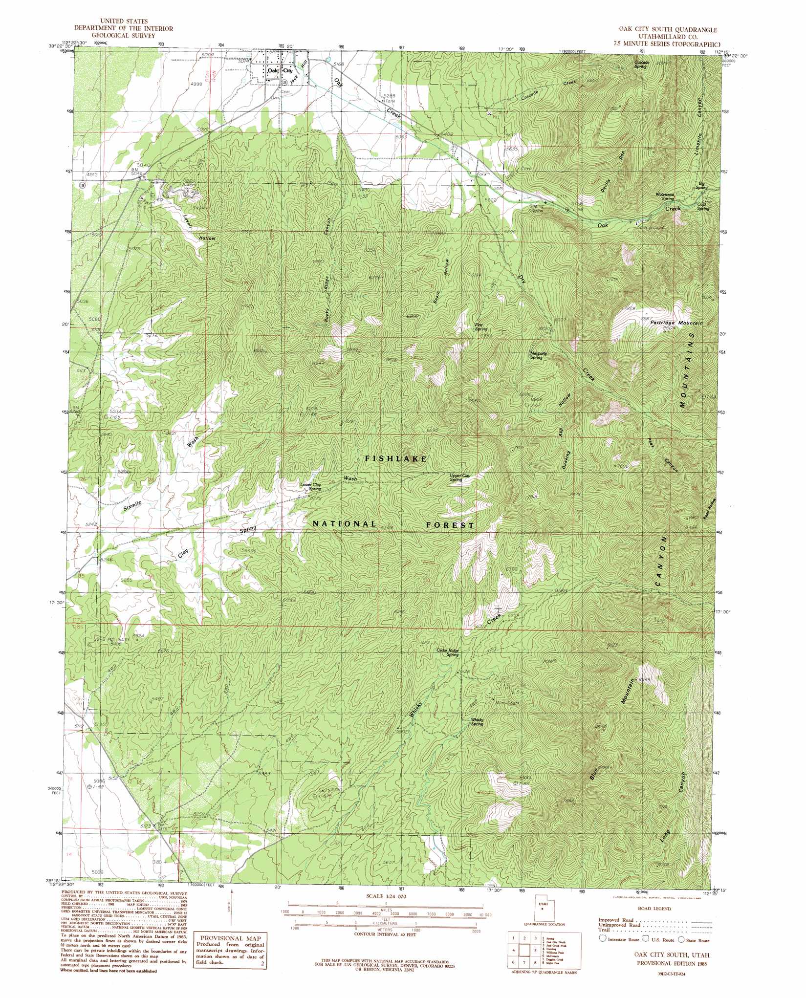
Oak City South Topo Map Utah
To zoom in, hover over the map of Oak City South
USGS Topo Quad 39112c3 - 1:24,000 scale
| Topo Map Name: | Oak City South |
| USGS Topo Quad ID: | 39112c3 |
| Print Size: | ca. 21 1/4" wide x 27" high |
| Southeast Coordinates: | 39.25° N latitude / 112.25° W longitude |
| Map Center Coordinates: | 39.3125° N latitude / 112.3125° W longitude |
| U.S. State: | UT |
| Filename: | o39112c3.jpg |
| Download Map JPG Image: | Oak City South topo map 1:24,000 scale |
| Map Type: | Topographic |
| Topo Series: | 7.5´ |
| Map Scale: | 1:24,000 |
| Source of Map Images: | United States Geological Survey (USGS) |
| Alternate Map Versions: |
Oak City South UT 1985, updated 1985 Download PDF Buy paper map Oak City South UT 2001, updated 2003 Download PDF Buy paper map Oak City South UT 2011 Download PDF Buy paper map Oak City South UT 2014 Download PDF Buy paper map |
| FStopo: | US Forest Service topo Oak City South is available: Download FStopo PDF Download FStopo TIF |
1:24,000 Topo Quads surrounding Oak City South
Rain Lake |
Lynndyl West |
Lynndyl East |
Champlin Peak |
Sage Valley |
Delta Ne |
Strong |
Oak City North |
Fool Creek Peak |
Mills |
Delta |
Harding |
Oak City South |
Williams Peak |
Scipio North |
Pavant Butte North |
Mccornick |
Duggins Creek |
Scipio Pass |
Scipio South |
Pavant Butte South |
The Sink |
Holden |
Coffee Peak |
Scipio Lake |
> Back to 39112a1 at 1:100,000 scale
> Back to 39112a1 at 1:250,000 scale
> Back to U.S. Topo Maps home
Oak City South topo map: Gazetteer
Oak City South: Areas
Partridge Mountain Research Natural Area elevation 2385m 7824′Oak City South: Populated Places
Oak City elevation 1558m 5111′Oak City South: Ranges
Canyon Mountains elevation 2398m 7867′Oak City South: Slopes
Jack Hill elevation 1570m 5150′Oak City South: Springs
Big Spring elevation 1876m 6154′Cascade Spring elevation 2197m 7208′
Cedar Ridge Spring elevation 1870m 6135′
Cold Spring elevation 1864m 6115′
First Spring elevation 1876m 6154′
Lower Clay Spring elevation 1773m 5816′
Maple Spring elevation 2082m 6830′
Mayparty Spring elevation 1911m 6269′
Quaking Asp Spring elevation 2020m 6627′
Upper Clay Spring elevation 1962m 6437′
Watercrest Spring elevation 1851m 6072′
Whisky Spring elevation 1867m 6125′
Oak City South: Streams
Cascade Creek elevation 2197m 7208′Dry Creek elevation 1676m 5498′
Oak City South: Summits
Blue Mountain elevation 2605m 8546′Oak City South: Valleys
Basin Hollow elevation 1687m 5534′Devils Den elevation 1829m 6000′
Limekiln Canyon elevation 1923m 6309′
Lovell Hollow elevation 1548m 5078′
Peak Canyon elevation 1988m 6522′
Quaking Asp Hollow elevation 1914m 6279′
Rocky Ridge Canyon elevation 1648m 5406′
Roger Hollow elevation 2138m 7014′
Oak City South digital topo map on disk
Buy this Oak City South topo map showing relief, roads, GPS coordinates and other geographical features, as a high-resolution digital map file on DVD: