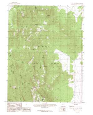
Fool Creek Peak Topo Map Utah
To zoom in, hover over the map of Fool Creek Peak
USGS Topo Quad 39112d2 - 1:24,000 scale
| Topo Map Name: | Fool Creek Peak |
| USGS Topo Quad ID: | 39112d2 |
| Print Size: | ca. 21 1/4" wide x 27" high |
| Southeast Coordinates: | 39.375° N latitude / 112.125° W longitude |
| Map Center Coordinates: | 39.4375° N latitude / 112.1875° W longitude |
| U.S. State: | UT |
| Filename: | o39112d2.jpg |
| Download Map JPG Image: | Fool Creek Peak topo map 1:24,000 scale |
| Map Type: | Topographic |
| Topo Series: | 7.5´ |
| Map Scale: | 1:24,000 |
| Source of Map Images: | United States Geological Survey (USGS) |
| Alternate Map Versions: |
Fool Creek Peak UT 1985, updated 1985 Download PDF Buy paper map Fool Creek Peak UT 2001, updated 2003 Download PDF Buy paper map Fool Creek Peak UT 2011 Download PDF Buy paper map Fool Creek Peak UT 2014 Download PDF Buy paper map |
| FStopo: | US Forest Service topo Fool Creek Peak is available: Download FStopo PDF Download FStopo TIF |
1:24,000 Topo Quads surrounding Fool Creek Peak
> Back to 39112a1 at 1:100,000 scale
> Back to 39112a1 at 1:250,000 scale
> Back to U.S. Topo Maps home
Fool Creek Peak topo map: Gazetteer
Fool Creek Peak: Cliffs
Enoch Point elevation 1782m 5846′Fool Creek Peak: Springs
Black Willow Spring elevation 1877m 6158′Cow Canyon Spring elevation 2158m 7080′
Mourning Dove Spring elevation 1913m 6276′
Pipe Spring elevation 1742m 5715′
Upper Narrows Spring elevation 2131m 6991′
Wide Canyon Spring elevation 2016m 6614′
Wildhorse Spring elevation 2043m 6702′
Fool Creek Peak: Streams
Dry Fork elevation 1698m 5570′Fool Creek Peak: Summits
Buck Peak elevation 2623m 8605′Fool Creek Peak elevation 2936m 9632′
Wild Horse Peak elevation 2311m 7582′
Fool Creek Peak: Valleys
Buck Hollow elevation 2197m 7208′Charley Johnson Canyon elevation 1964m 6443′
Cow Canyon elevation 1956m 6417′
Davison Canyon elevation 2269m 7444′
Flat Canyon elevation 1685m 5528′
Horse Hollow elevation 2124m 6968′
Little Pole Canyon elevation 1866m 6122′
Mill Canyon elevation 1927m 6322′
Mine Hollow elevation 1805m 5921′
Netties Canyon elevation 2014m 6607′
Pass Canyon elevation 1565m 5134′
The Narrows elevation 1801m 5908′
Wide Canyon elevation 1708m 5603′
Wild Horse Canyon elevation 1690m 5544′
Wringer Canyon elevation 1755m 5757′
Fool Creek Peak digital topo map on disk
Buy this Fool Creek Peak topo map showing relief, roads, GPS coordinates and other geographical features, as a high-resolution digital map file on DVD:


