Tanner Creek Narrows Topo Map Utah
To zoom in, hover over the map of Tanner Creek Narrows
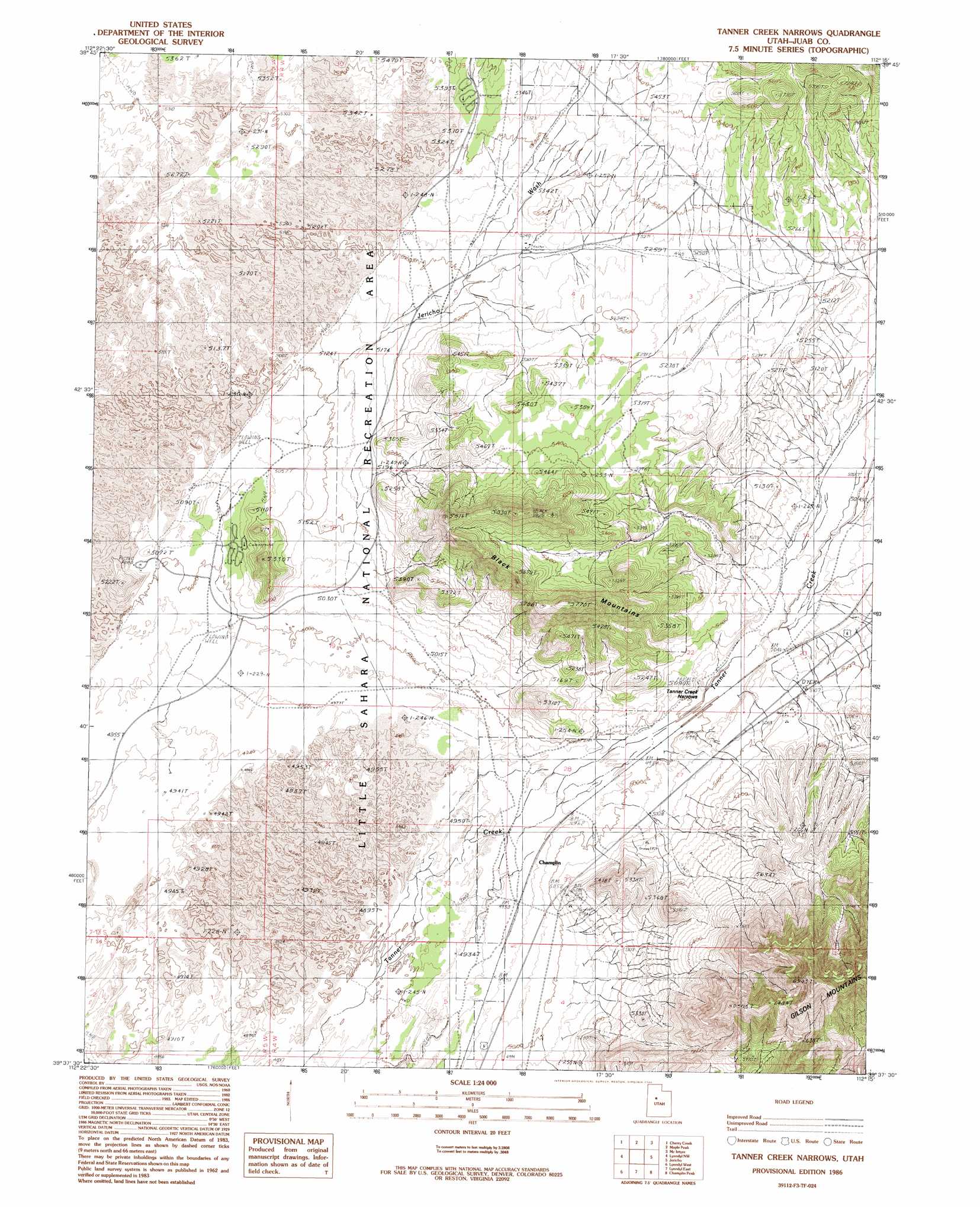
USGS Topo Quad 39112f3 - 1:24,000 scale
| Topo Map Name: | Tanner Creek Narrows |
| USGS Topo Quad ID: | 39112f3 |
| Print Size: | ca. 21 1/4" wide x 27" high |
| Southeast Coordinates: | 39.625° N latitude / 112.25° W longitude |
| Map Center Coordinates: | 39.6875° N latitude / 112.3125° W longitude |
| U.S. State: | UT |
| Filename: | o39112f3.jpg |
| Download Map JPG Image: | Tanner Creek Narrows topo map 1:24,000 scale |
| Map Type: | Topographic |
| Topo Series: | 7.5´ |
| Map Scale: | 1:24,000 |
| Source of Map Images: | United States Geological Survey (USGS) |
| Alternate Map Versions: |
Tanner Creek Narrows UT 1986, updated 1986 Download PDF Buy paper map Tanner Creek Narrows UT 2010 Download PDF Buy paper map Tanner Creek Narrows UT 2014 Download PDF Buy paper map |
1:24,000 Topo Quads surrounding Tanner Creek Narrows
Erickson Knoll |
Dutch Peak |
Sabie Mountain |
Tintic Junction |
Eureka |
Desert Mountain Pass |
Cherry Creek |
Maple Peak |
Mcintyre |
Tintic Mountain |
Desert Mountain Reservoir |
Lynndyl Nw |
Tanner Creek Narrows |
Jericho |
Furner Ridge |
Rain Lake |
Lynndyl West |
Lynndyl East |
Champlin Peak |
Sage Valley |
Delta Ne |
Strong |
Oak City North |
Fool Creek Peak |
Mills |
> Back to 39112e1 at 1:100,000 scale
> Back to 39112a1 at 1:250,000 scale
> Back to U.S. Topo Maps home
Tanner Creek Narrows topo map: Gazetteer
Tanner Creek Narrows: Airports
Sahara Sand Dunes Heliport elevation 1559m 5114′Tanner Creek Narrows: Gaps
Tanner Creek Narrows elevation 1525m 5003′Tanner Creek Narrows: Parks
Little Sahara National Recreation Area elevation 1556m 5104′Tanner Creek Narrows: Populated Places
Champlin elevation 1513m 4963′Tanner Creek Narrows: Summits
Black Mountains elevation 1736m 5695′Tanner Creek Narrows: Valleys
Jericho Wash elevation 1549m 5082′Tanner Creek Narrows digital topo map on disk
Buy this Tanner Creek Narrows topo map showing relief, roads, GPS coordinates and other geographical features, as a high-resolution digital map file on DVD: