Dutch Peak Topo Map Utah
To zoom in, hover over the map of Dutch Peak
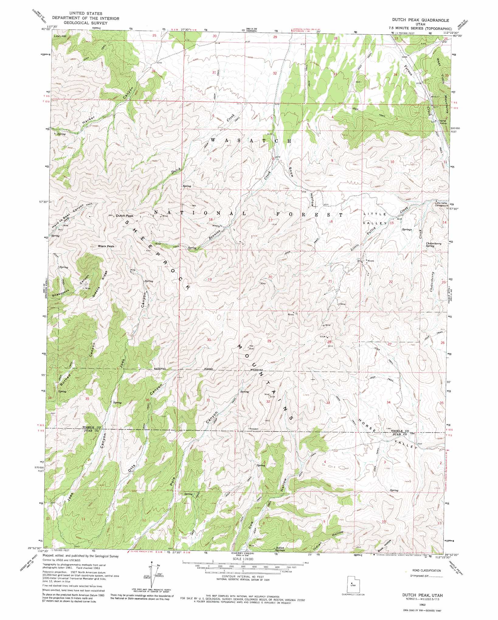
USGS Topo Quad 39112h4 - 1:24,000 scale
| Topo Map Name: | Dutch Peak |
| USGS Topo Quad ID: | 39112h4 |
| Print Size: | ca. 21 1/4" wide x 27" high |
| Southeast Coordinates: | 39.875° N latitude / 112.375° W longitude |
| Map Center Coordinates: | 39.9375° N latitude / 112.4375° W longitude |
| U.S. State: | UT |
| Filename: | o39112h4.jpg |
| Download Map JPG Image: | Dutch Peak topo map 1:24,000 scale |
| Map Type: | Topographic |
| Topo Series: | 7.5´ |
| Map Scale: | 1:24,000 |
| Source of Map Images: | United States Geological Survey (USGS) |
| Alternate Map Versions: |
Dutch Peak UT 1963, updated 1964 Download PDF Buy paper map Dutch Peak UT 1963, updated 1980 Download PDF Buy paper map Dutch Peak UT 1963, updated 1984 Download PDF Buy paper map Dutch Peak UT 1998, updated 2002 Download PDF Buy paper map Dutch Peak UT 2011 Download PDF Buy paper map Dutch Peak UT 2014 Download PDF Buy paper map |
| FStopo: | US Forest Service topo Dutch Peak is available: Download FStopo PDF Download FStopo TIF |
1:24,000 Topo Quads surrounding Dutch Peak
Davis Knolls |
Onaqui Mountains South |
Faust |
Vernon Ne |
Fivemile Pass |
Indian Peaks |
Lookout Pass |
Vernon |
Lofgreen |
Boulter Peak |
Indian Springs |
Erickson Knoll |
Dutch Peak |
Sabie Mountain |
Tintic Junction |
Erickson Wash Sw |
Desert Mountain Pass |
Cherry Creek |
Maple Peak |
Mcintyre |
Crater Bench Reservoir |
Desert Mountain Reservoir |
Lynndyl Nw |
Tanner Creek Narrows |
Jericho |
> Back to 39112e1 at 1:100,000 scale
> Back to 39112a1 at 1:250,000 scale
> Back to U.S. Topo Maps home
Dutch Peak topo map: Gazetteer
Dutch Peak: Basins
Little Valley elevation 2064m 6771′Dutch Peak: Dams
Vernon Dam elevation 1870m 6135′Dutch Peak: Forests
Wasatch National Forest-Vernon Division elevation 1866m 6122′Dutch Peak: Ranges
Sheeprock Mountains elevation 2502m 8208′Dutch Peak: Reservoirs
Vernon Reservoir elevation 1870m 6135′Dutch Peak: Ridges
Greens Ridge elevation 2540m 8333′Dutch Peak: Springs
Chokecherry Spring elevation 2036m 6679′Indian Springs elevation 2009m 6591′
Dutch Peak: Streams
Chokecherry Creek elevation 1969m 6459′Dutch Peak: Summits
Black Peak elevation 2711m 8894′Dutch Peak elevation 2726m 8943′
Red Skin Knolls elevation 2160m 7086′
Dutch Peak: Valleys
Grove Hollow elevation 1876m 6154′Harker Canyon elevation 1963m 6440′
Joes Canyon elevation 1806m 5925′
Snow Hollow elevation 1946m 6384′
Dutch Peak digital topo map on disk
Buy this Dutch Peak topo map showing relief, roads, GPS coordinates and other geographical features, as a high-resolution digital map file on DVD: