Indian Springs Topo Map Utah
To zoom in, hover over the map of Indian Springs
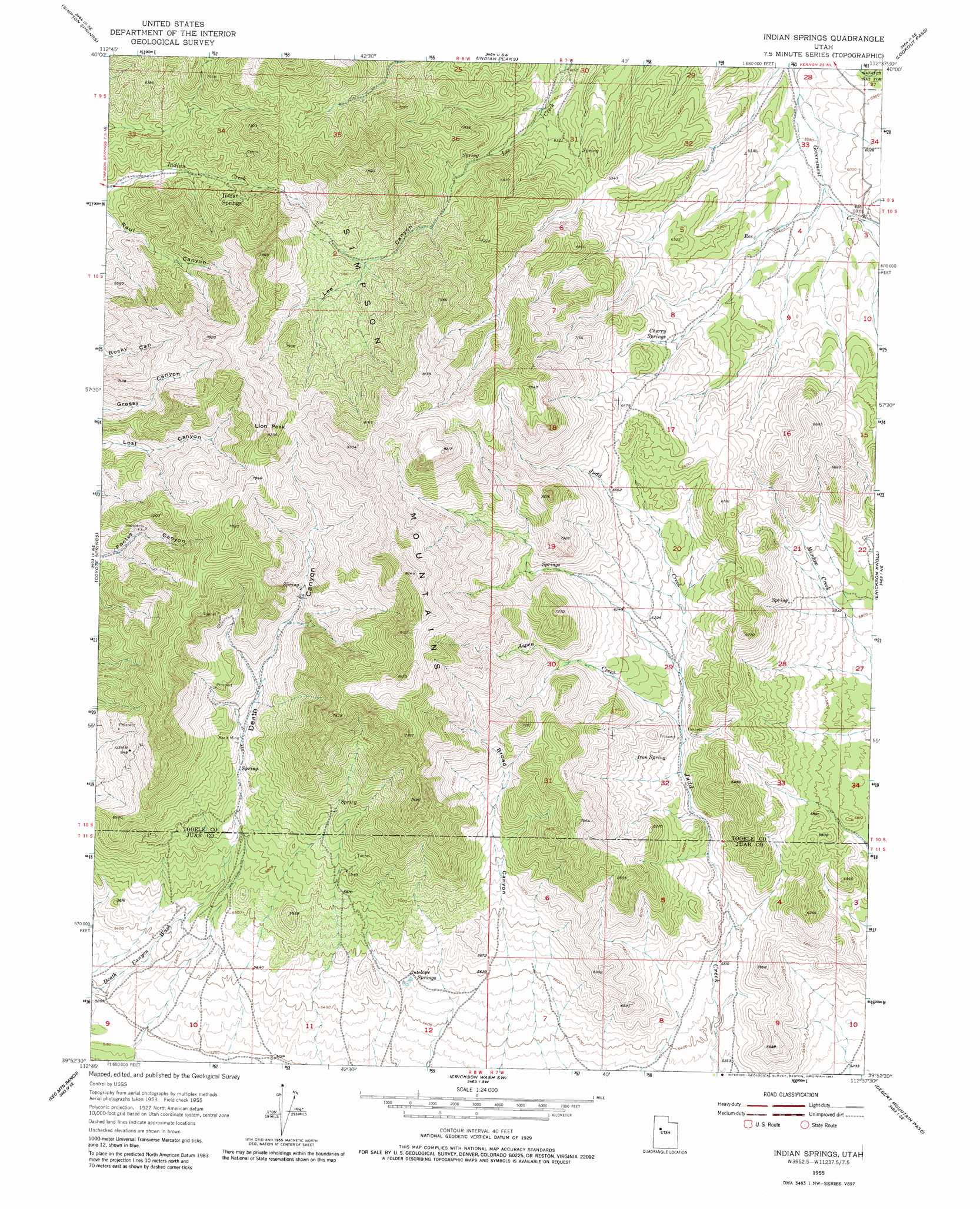
USGS Topo Quad 39112h6 - 1:24,000 scale
| Topo Map Name: | Indian Springs |
| USGS Topo Quad ID: | 39112h6 |
| Print Size: | ca. 21 1/4" wide x 27" high |
| Southeast Coordinates: | 39.875° N latitude / 112.625° W longitude |
| Map Center Coordinates: | 39.9375° N latitude / 112.6875° W longitude |
| U.S. State: | UT |
| Filename: | o39112h6.jpg |
| Download Map JPG Image: | Indian Springs topo map 1:24,000 scale |
| Map Type: | Topographic |
| Topo Series: | 7.5´ |
| Map Scale: | 1:24,000 |
| Source of Map Images: | United States Geological Survey (USGS) |
| Alternate Map Versions: |
Indian Springs UT 1955, updated 1956 Download PDF Buy paper map Indian Springs UT 1955, updated 1975 Download PDF Buy paper map Indian Springs UT 1955, updated 1982 Download PDF Buy paper map Indian Springs UT 1998, updated 2002 Download PDF Buy paper map Indian Springs UT 2011 Download PDF Buy paper map Indian Springs UT 2014 Download PDF Buy paper map |
| FStopo: | US Forest Service topo Indian Springs is available: Download FStopo PDF Download FStopo TIF |
1:24,000 Topo Quads surrounding Indian Springs
Camels Back Ridge Nw |
Camels Back Ridge Ne |
Davis Knolls |
Onaqui Mountains South |
Faust |
Camels Back Ridge Sw |
Simpson Springs |
Indian Peaks |
Lookout Pass |
Vernon |
Table Mountain |
Coyote Springs |
Indian Springs |
Erickson Knoll |
Dutch Peak |
Keg Pass |
Keg Mountain Ranch |
Erickson Wash Sw |
Desert Mountain Pass |
Cherry Creek |
Picture Rock Hills |
The Hogback |
Crater Bench Reservoir |
Desert Mountain Reservoir |
Lynndyl Nw |
> Back to 39112e1 at 1:100,000 scale
> Back to 39112a1 at 1:250,000 scale
> Back to U.S. Topo Maps home
Indian Springs topo map: Gazetteer
Indian Springs: Mines
Bar X Mine elevation 1842m 6043′Indian Springs: Ranges
Simpson Mountains elevation 2188m 7178′Indian Springs: Springs
Antelope Springs elevation 1695m 5561′Cherry Springs elevation 1976m 6482′
Corral elevation 1903m 6243′
Indian Springs elevation 2037m 6683′
Iron Spring elevation 1845m 6053′
Indian Springs: Streams
Aspen Creek elevation 1802m 5912′Indian Springs: Summits
Lion Peak elevation 2469m 8100′Indian Springs: Valleys
Broad Canyon elevation 1754m 5754′Death Canyon elevation 1674m 5492′
Indian Springs digital topo map on disk
Buy this Indian Springs topo map showing relief, roads, GPS coordinates and other geographical features, as a high-resolution digital map file on DVD: