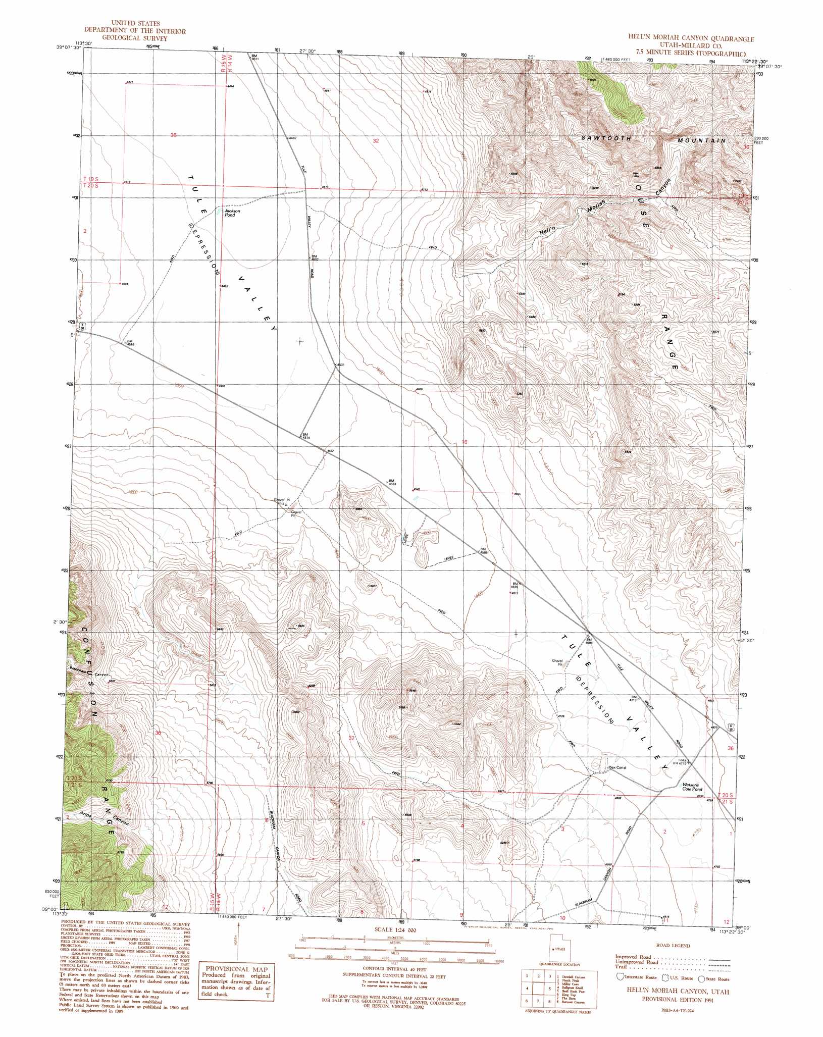
Hell'N Maria Canyon Topo Map Utah
To zoom in, hover over the map of Hell'N Maria Canyon
USGS Topo Quad 39113a4 - 1:24,000 scale
| Topo Map Name: | Hell'N Maria Canyon |
| USGS Topo Quad ID: | 39113a4 |
| Print Size: | ca. 21 1/4" wide x 27" high |
| Southeast Coordinates: | 39° N latitude / 113.375° W longitude |
| Map Center Coordinates: | 39.0625° N latitude / 113.4375° W longitude |
| U.S. State: | UT |
| Filename: | o39113a4.jpg |
| Download Map JPG Image: | Hell'N Maria Canyon topo map 1:24,000 scale |
| Map Type: | Topographic |
| Topo Series: | 7.5´ |
| Map Scale: | 1:24,000 |
| Source of Map Images: | United States Geological Survey (USGS) |
| Alternate Map Versions: |
Hell'n Moriah Canyon UT 1991, updated 1991 Download PDF Buy paper map Hell'n Moriah Canyon UT 2010 Download PDF Buy paper map Hell'n Moriah Canyon UT 2014 Download PDF Buy paper map |
1:24,000 Topo Quads surrounding Hell'N Maria Canyon
Cowboy Pass |
Chalk Knolls |
Swasey Peak Sw |
Marjum Pass |
Whirlwind Valley Sw |
Conger Mountain |
Dowdell Canyon |
Notch Peak |
Miller Cove |
Long Ridge Reservoir |
Thompson Knoll |
Bullgrass Knoll |
Hell'N Maria Canyon |
Skull Rock Pass |
Long Ridge Sw |
Pyramid Knoll |
King Top |
The Barn |
Burnout Canyon |
Needle Point |
Middle Mountain |
Crystal Peak |
Warm Point |
Red Tops |
Sevier Lake Sw |
> Back to 39113a1 at 1:100,000 scale
> Back to 39112a1 at 1:250,000 scale
> Back to U.S. Topo Maps home
Hell'N Maria Canyon topo map: Gazetteer
Hell'N Maria Canyon: Basins
Hell'n Moriah Kitchen elevation 2240m 7349′Hell'N Maria Canyon: Lakes
Jackson Pond elevation 1366m 4481′Watsons Cow Pond elevation 1455m 4773′
Hell'N Maria Canyon: Valleys
Arms Canyon elevation 1876m 6154′Blackham Canyon elevation 1697m 5567′
Hell'n Moriah Canyon elevation 1536m 5039′
Hell'N Maria Canyon digital topo map on disk
Buy this Hell'N Maria Canyon topo map showing relief, roads, GPS coordinates and other geographical features, as a high-resolution digital map file on DVD: