Cave Creek Topo Map Nevada
To zoom in, hover over the map of Cave Creek
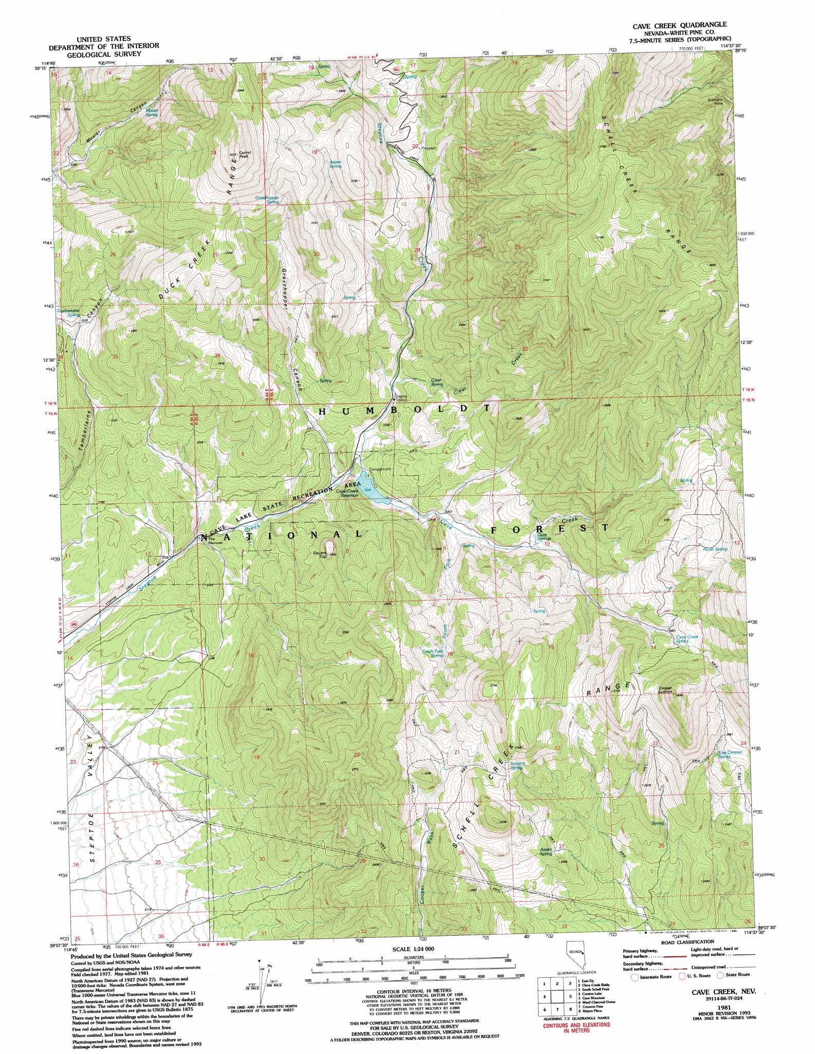
USGS Topo Quad 39114b6 - 1:24,000 scale
| Topo Map Name: | Cave Creek |
| USGS Topo Quad ID: | 39114b6 |
| Print Size: | ca. 21 1/4" wide x 27" high |
| Southeast Coordinates: | 39.125° N latitude / 114.625° W longitude |
| Map Center Coordinates: | 39.1875° N latitude / 114.6875° W longitude |
| U.S. State: | NV |
| Filename: | o39114b6.jpg |
| Download Map JPG Image: | Cave Creek topo map 1:24,000 scale |
| Map Type: | Topographic |
| Topo Series: | 7.5´ |
| Map Scale: | 1:24,000 |
| Source of Map Images: | United States Geological Survey (USGS) |
| Alternate Map Versions: |
Cave Creek NV 1981, updated 1982 Download PDF Buy paper map Cave Creek NV 1981, updated 1994 Download PDF Buy paper map Cave Creek NV 2012 Download PDF Buy paper map Cave Creek NV 2014 Download PDF Buy paper map |
| FStopo: | US Forest Service topo Cave Creek is available: Download FStopo PDF Download FStopo TIF |
1:24,000 Topo Quads surrounding Cave Creek
Lusetti Canyon |
Mcgill |
Duck Creek Valley |
North Schell Peak |
Third Butte West |
Ruth |
East Ely |
Cleve Creek Baldy |
South Schell Peak |
Yelland Dry Lake |
Ely |
Comins Lake |
Cave Creek |
Cave Mountain |
South Bastian Spring |
Ward Mountain |
Ward Charcoal Ovens |
Connors Pass |
Majors Place |
Hogum |
Sawmill Canyon |
White Rock Creek |
Horse Camp Springs |
North Spring Point |
Baking Powder Flat |
> Back to 39114a1 at 1:100,000 scale
> Back to 39114a1 at 1:250,000 scale
> Back to U.S. Topo Maps home
Cave Creek topo map: Gazetteer
Cave Creek: Dams
Cave Creek Dam elevation 2250m 7381′Cave Creek: Gaps
The Narrows elevation 2141m 7024′Cave Creek: Mines
Kolcheck Mine elevation 2602m 8536′Cave Creek: Parks
Cave Lake State Park elevation 2194m 7198′Cave Creek: Ranges
Schell Creek Range elevation 2701m 8861′Cave Creek: Reservoirs
Cave Creek Reservoir elevation 2250m 7381′Cave Creek: Springs
Aspen Spring elevation 2609m 8559′Aspen Spring elevation 2390m 7841′
Cave Creek Spring elevation 2525m 8284′
Cave Springs elevation 2319m 7608′
Clear Spring elevation 2342m 7683′
East Canyon Spring elevation 2536m 8320′
Grasshopper Spring elevation 2597m 8520′
Mosier Spring elevation 2420m 7939′
North Spring elevation 2717m 8914′
South Fork Spring elevation 2434m 7985′
Summit Spring elevation 2581m 8467′
Tamberlaine Spring elevation 2337m 7667′
Cave Creek: Streams
Cave Creek elevation 2217m 7273′Clear Creek elevation 2265m 7431′
South Fork Cave Creek elevation 2266m 7434′
South Fork Steptoe Creek elevation 2310m 7578′
Cave Creek: Summits
Camel Peak elevation 3066m 10059′Cooper Summit elevation 2839m 9314′
Square Top elevation 2434m 7985′
Cave Creek: Valleys
Grasshopper Canyon elevation 2189m 7181′Cave Creek digital topo map on disk
Buy this Cave Creek topo map showing relief, roads, GPS coordinates and other geographical features, as a high-resolution digital map file on DVD: