Treasure Hill Topo Map Nevada
To zoom in, hover over the map of Treasure Hill
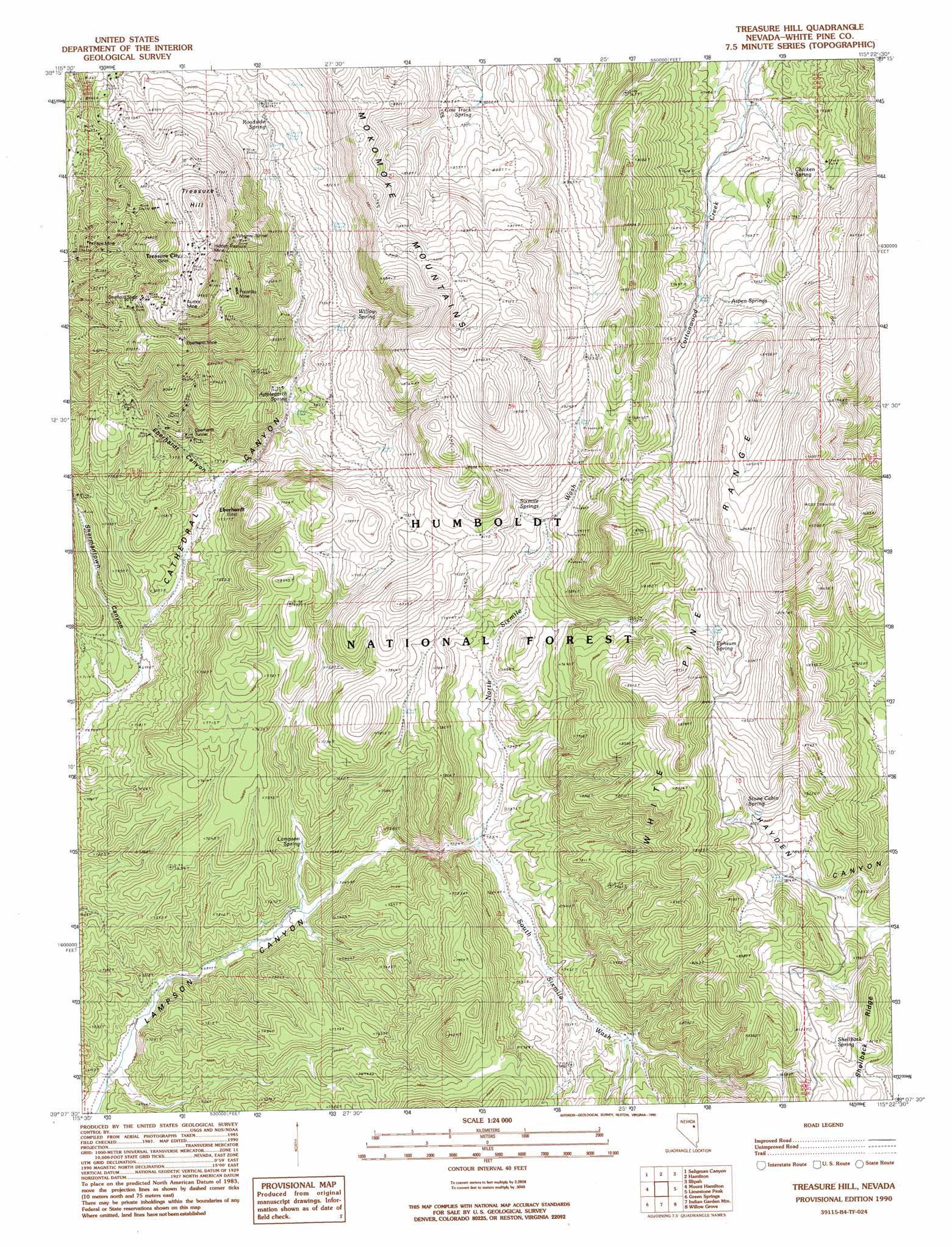
USGS Topo Quad 39115b4 - 1:24,000 scale
| Topo Map Name: | Treasure Hill |
| USGS Topo Quad ID: | 39115b4 |
| Print Size: | ca. 21 1/4" wide x 27" high |
| Southeast Coordinates: | 39.125° N latitude / 115.375° W longitude |
| Map Center Coordinates: | 39.1875° N latitude / 115.4375° W longitude |
| U.S. State: | NV |
| Filename: | o39115b4.jpg |
| Download Map JPG Image: | Treasure Hill topo map 1:24,000 scale |
| Map Type: | Topographic |
| Topo Series: | 7.5´ |
| Map Scale: | 1:24,000 |
| Source of Map Images: | United States Geological Survey (USGS) |
| Alternate Map Versions: |
Treasure Hill NV 1990, updated 1990 Download PDF Buy paper map Treasure Hill NV 2012 Download PDF Buy paper map Treasure Hill NV 2014 Download PDF Buy paper map |
| FStopo: | US Forest Service topo Treasure Hill is available: Download FStopo PDF Download FStopo TIF |
1:24,000 Topo Quads surrounding Treasure Hill
Pancake Summit |
East Of Pancake Summit |
Antelope Mountain |
Sammys Springs |
Marking Corral Summit |
Pancake Summit Sw |
Seligman Canyon |
Hamilton |
Illipah |
Waldy Pond |
Green Springs Nw |
Mount Hamilton |
Treasure Hill |
Limestone Peak |
Railroad Crossing Dam |
Green Springs Sw |
Green Springs |
Indian Garden Mountain |
Easter Springs |
Blackjack Springs |
Duckwater |
Duckwater Ne |
Currant Mountain |
Horse Track Spring |
Badger Hole Spring |
> Back to 39115a1 at 1:100,000 scale
> Back to 39114a1 at 1:250,000 scale
> Back to U.S. Topo Maps home
Treasure Hill topo map: Gazetteer
Treasure Hill: Flats
Bromide Flat elevation 2801m 9189′Chloride Flat elevation 2744m 9002′
Picotillo Flat elevation 2705m 8874′
Pogonip Flat elevation 2722m 8930′
Treasure Hill: Mines
Argyle Mine elevation 2287m 7503′Aurora Mine elevation 2787m 9143′
Blue Bell Mine elevation 2480m 8136′
Eberhardt Mine elevation 2501m 8205′
Emersly Mine elevation 2695m 8841′
Fay Mine elevation 2521m 8270′
Hidden Treasure Mine elevation 2781m 9124′
Hidden Treasure Two South Mine elevation 2764m 9068′
Keystone Mine elevation 2663m 8736′
Mammoth Mine elevation 2772m 9094′
Mazeppa Mine elevation 2551m 8369′
Onetha Mine elevation 2490m 8169′
Pocotillo Mine elevation 2681m 8795′
Silver Glance Mine elevation 2526m 8287′
Stafford Shaft elevation 2672m 8766′
Virginia Mine elevation 2603m 8540′
Ward Beecher Mine elevation 2764m 9068′
Treasure Hill: Populated Places
Eberhardt elevation 2199m 7214′Greenville (historical) elevation 2551m 8369′
Menken (historical) elevation 2375m 7791′
Picotillo (historical) elevation 2705m 8874′
Pogonip elevation 2660m 8727′
Treasure City (historical) elevation 2806m 9206′
White Pine City (historical) elevation 2728m 8950′
Treasure Hill: Post Offices
Eberhardt Post Office (historical) elevation 2199m 7214′Treasure City Post Office (historical) elevation 2806m 9206′
Treasure Hill: Ranges
Mokomoke Mountains elevation 2720m 8923′Treasure Hill: Springs
Applegarth Spring elevation 2284m 7493′Aspen Springs elevation 2462m 8077′
Cow Track Spring elevation 2565m 8415′
Ephsum Spring elevation 2492m 8175′
Lampson Spring elevation 2187m 7175′
Roadside Spring elevation 2436m 7992′
Shellback Spring elevation 2464m 8083′
Sixmile Springs elevation 2421m 7942′
Stone Cabin Spring elevation 2448m 8031′
Willow Spring elevation 2380m 7808′
Treasure Hill: Streams
North Sixmile Wash elevation 2206m 7237′South Sixmile Wash elevation 2206m 7237′
Treasure Hill: Summits
Mokomoke Hill elevation 2673m 8769′Treasure Hill elevation 2857m 9373′
Treasure Hill: Tunnels
Eberhardt Tunnel elevation 2369m 7772′Wheeler Tunnel elevation 2614m 8576′
Treasure Hill: Valleys
Eberhardt Canyon elevation 2207m 7240′Shermantown Canyon elevation 2139m 7017′
Treasure Hill digital topo map on disk
Buy this Treasure Hill topo map showing relief, roads, GPS coordinates and other geographical features, as a high-resolution digital map file on DVD: