Riepetown Topo Map Nevada
To zoom in, hover over the map of Riepetown
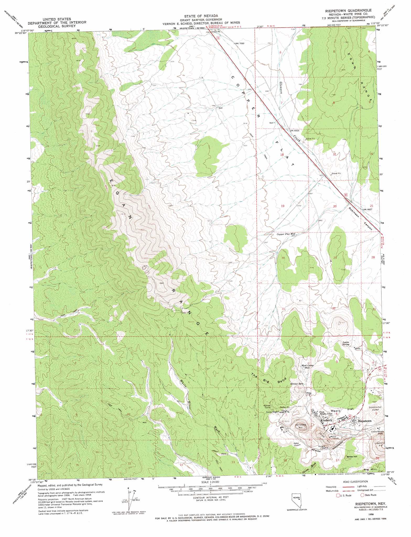
USGS Topo Quad 39115c1 - 1:24,000 scale
| Topo Map Name: | Riepetown |
| USGS Topo Quad ID: | 39115c1 |
| Print Size: | ca. 21 1/4" wide x 27" high |
| Southeast Coordinates: | 39.25° N latitude / 115° W longitude |
| Map Center Coordinates: | 39.3125° N latitude / 115.0625° W longitude |
| U.S. State: | NV |
| Filename: | o39115c1.jpg |
| Download Map JPG Image: | Riepetown topo map 1:24,000 scale |
| Map Type: | Topographic |
| Topo Series: | 7.5´ |
| Map Scale: | 1:24,000 |
| Source of Map Images: | United States Geological Survey (USGS) |
| Alternate Map Versions: |
Reipetown NV 1958, updated 1961 Download PDF Buy paper map Riepetown NV 1958, updated 1961 Download PDF Buy paper map Riepetown NV 1958, updated 1967 Download PDF Buy paper map Riepetown NV 2012 Download PDF Buy paper map Riepetown NV 2014 Download PDF Buy paper map |
1:24,000 Topo Quads surrounding Riepetown
Dickenson Well |
Thirtymile Ranch |
Combs Creek |
Steptoe Ranch |
Steptoe |
Sammys Springs |
Marking Corral Summit |
Robinson Summit |
Lusetti Canyon |
Mcgill |
Illipah |
Waldy Pond |
Riepetown |
Ruth |
East Ely |
Limestone Peak |
Railroad Crossing Dam |
Giroux Wash |
Ely |
Comins Lake |
Easter Springs |
Blackjack Springs |
Preston Reservoir |
Ward Mountain |
Ward Charcoal Ovens |
> Back to 39115a1 at 1:100,000 scale
> Back to 39114a1 at 1:250,000 scale
> Back to U.S. Topo Maps home
Riepetown topo map: Gazetteer
Riepetown: Bends
The Big Bend elevation 2328m 7637′Riepetown: Flats
Copper Flat elevation 2123m 6965′Weary Flat elevation 2168m 7112′
Riepetown: Mines
Alpha Shaft elevation 2177m 7142′Boston-Ely Shaft elevation 2235m 7332′
Emma Nevada Shaft elevation 2176m 7139′
Emma Shaft elevation 2215m 7267′
Matilda Tunnel elevation 2239m 7345′
Morris Shaft elevation 2183m 7162′
Old Glory Shaft elevation 2210m 7250′
Richard Shaft elevation 2192m 7191′
Taylor Mine elevation 2222m 7290′
Tripp Pit elevation 2122m 6961′
Tripp Veteran Pit elevation 2229m 7312′
Veteran Pit elevation 2083m 6833′
Veteran Shaft elevation 2222m 7290′
Riepetown: Populated Places
Kimberly elevation 2206m 7237′Riepetown elevation 2157m 7076′
Veteran (historical) elevation 2237m 7339′
Riepetown: Post Offices
Kimberly Post Office elevation 2206m 7237′Riepetown Post Office (historical) elevation 2157m 7076′
Riepetown: Ridges
Jog Along Ridge elevation 2191m 7188′Rusty Ridge elevation 2248m 7375′
Riepetown: Springs
Giroux Springs elevation 2255m 7398′Lyons Spring elevation 2145m 7037′
Riepetown: Summits
Pilot Knob elevation 2237m 7339′White Hill elevation 2269m 7444′
Riepetown: Wells
Copper Flat Well elevation 2114m 6935′Deep Well elevation 2159m 7083′
West Camp Well elevation 2240m 7349′
Riepetown digital topo map on disk
Buy this Riepetown topo map showing relief, roads, GPS coordinates and other geographical features, as a high-resolution digital map file on DVD: