Diamond Springs Topo Map Nevada
To zoom in, hover over the map of Diamond Springs
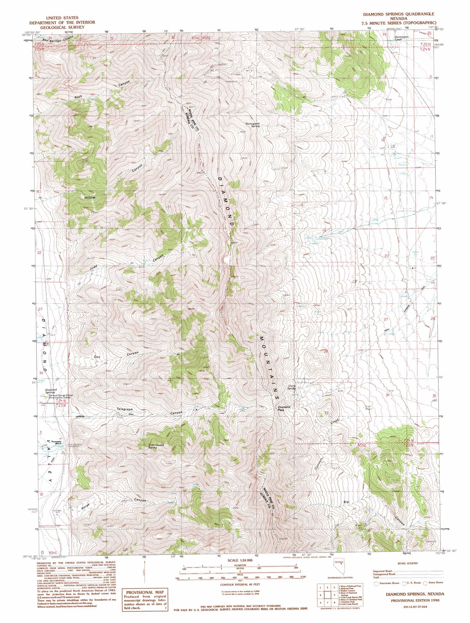
USGS Topo Quad 39115h7 - 1:24,000 scale
| Topo Map Name: | Diamond Springs |
| USGS Topo Quad ID: | 39115h7 |
| Print Size: | ca. 21 1/4" wide x 27" high |
| Southeast Coordinates: | 39.875° N latitude / 115.75° W longitude |
| Map Center Coordinates: | 39.9375° N latitude / 115.8125° W longitude |
| U.S. State: | NV |
| Filename: | o39115h7.jpg |
| Download Map JPG Image: | Diamond Springs topo map 1:24,000 scale |
| Map Type: | Topographic |
| Topo Series: | 7.5´ |
| Map Scale: | 1:24,000 |
| Source of Map Images: | United States Geological Survey (USGS) |
| Alternate Map Versions: |
Diamond Springs NV 1990, updated 1990 Download PDF Buy paper map Diamond Springs NV 2012 Download PDF Buy paper map Diamond Springs NV 2014 Download PDF Buy paper map |
1:24,000 Topo Quads surrounding Diamond Springs
Mineral Hill |
Garcia Flat |
Sadler Basin |
Belmont Creek |
Pearl Peak |
Telegraph Canyon |
West Of Railroad Pass |
Railroad Pass |
Walker Canyon |
Sherman Mountain |
Bailey Pass |
West Of Diamond Springs |
Diamond Springs |
Cold Creek Ranch Nw |
Big Bald Mountain |
Tule Dam Spring |
West Of Christina Peak |
Christina Peak |
Cold Creek Ranch |
Mooney Basin Summit |
Whistler Mountain |
North Of Eureka |
Rattlesnake Mountain |
Buck Mountain West |
Buck Mountain East |
> Back to 39115e1 at 1:100,000 scale
> Back to 39114a1 at 1:250,000 scale
> Back to U.S. Topo Maps home
Diamond Springs topo map: Gazetteer
Diamond Springs: Areas
Huntington Creek Mining Area elevation 2103m 6899′Diamond Springs: Gaps
Overland Pass elevation 2275m 7463′Diamond Springs: Populated Places
Birch (historical) elevation 1788m 5866′Diamond Springs: Post Offices
Birch Post Office (historical) elevation 1788m 5866′Diamond Springs: Ranges
Diamond Mountains elevation 2792m 9160′Diamond Springs: Springs
Alba Spring elevation 2051m 6729′Carpenter Spring elevation 2463m 8080′
Corta Spring elevation 2105m 6906′
Cottonwood Spring elevation 2205m 7234′
Cottonwood Spring elevation 2190m 7185′
Duck Pond elevation 1774m 5820′
Echemendy Number Eight elevation 2171m 7122′
Echemendy Number Five elevation 2039m 6689′
Echemendy Number Nine elevation 1986m 6515′
Echemendy Number Seven elevation 2171m 7122′
Echemendy Number Six elevation 1911m 6269′
Echemendy Number Ten elevation 1986m 6515′
Headwaters Springs elevation 1848m 6062′
Heath Spring elevation 2108m 6916′
Meadow Springs elevation 1891m 6204′
Murray Spring elevation 2185m 7168′
Portuguese Spring elevation 2305m 7562′
Rock Springs elevation 2321m 7614′
Thompson Ranch Spring elevation 1774m 5820′
Diamond Springs: Valleys
Big Canyon elevation 1975m 6479′Cox Canyon elevation 1796m 5892′
Horse Canyon elevation 1796m 5892′
Judd Canyon elevation 1810m 5938′
Telegraph Canyon elevation 1794m 5885′
Diamond Springs digital topo map on disk
Buy this Diamond Springs topo map showing relief, roads, GPS coordinates and other geographical features, as a high-resolution digital map file on DVD: