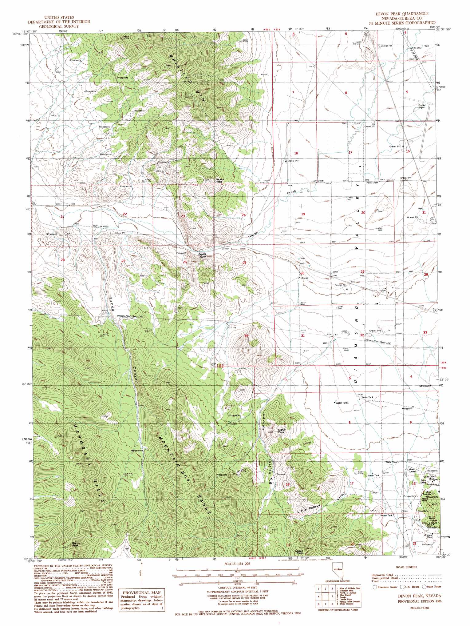
Devon Peak Topo Map Nevada
To zoom in, hover over the map of Devon Peak
USGS Topo Quad 39116e1 - 1:24,000 scale
| Topo Map Name: | Devon Peak |
| USGS Topo Quad ID: | 39116e1 |
| Print Size: | ca. 21 1/4" wide x 27" high |
| Southeast Coordinates: | 39.5° N latitude / 116° W longitude |
| Map Center Coordinates: | 39.5625° N latitude / 116.0625° W longitude |
| U.S. State: | NV |
| Filename: | o39116e1.jpg |
| Download Map JPG Image: | Devon Peak topo map 1:24,000 scale |
| Map Type: | Topographic |
| Topo Series: | 7.5´ |
| Map Scale: | 1:24,000 |
| Source of Map Images: | United States Geological Survey (USGS) |
| Alternate Map Versions: |
Devon Peak NV 1986, updated 1987 Download PDF Buy paper map Devon Peak NV 2012 Download PDF Buy paper map Devon Peak NV 2014 Download PDF Buy paper map |
1:24,000 Topo Quads surrounding Devon Peak
Roberts Creek Mountain |
Garden Pass |
Tule Dam Spring |
West Of Christina Peak |
Christina Peak |
Bartine Ranch Ne |
West Of Whistler Mountain |
Whistler Mountain |
North Of Eureka |
Rattlesnake Mountain |
Bartine Ranch |
Hay Ranch |
Devon Peak |
Eureka |
Diamond Peak |
Antelope Meadow |
Combs Peak |
Spring Valley Summit |
Pinto Summit |
Silverado Mountain |
Sullivan Wash |
West Of Bellevue Peak |
Bellevue Peak |
Pinto Summit Sw |
Black Point |
> Back to 39116e1 at 1:100,000 scale
> Back to 39116a1 at 1:250,000 scale
> Back to U.S. Topo Maps home
Devon Peak topo map: Gazetteer
Devon Peak: Airports
Eureka Airport elevation 1813m 5948′Devon Peak: Gaps
Devils Gate elevation 1832m 6010′Devon Peak: Mines
Chance Mine elevation 1992m 6535′Price and Davis Mine elevation 1967m 6453′
Silver Lick Mine elevation 1953m 6407′
Wales Mine elevation 1978m 6489′
Devon Peak: Summits
Anchor Peak elevation 2043m 6702′Devon Peak elevation 2584m 8477′
Modoc Peak elevation 2265m 7431′
Signal Peak elevation 2105m 6906′
Devon Peak: Valleys
Big Reilley Canyon elevation 1885m 6184′Little Reilley Canyon elevation 1928m 6325′
Swallow Canyon elevation 1817m 5961′
Yahoo Canyon elevation 1845m 6053′
Zulu Canyon elevation 2002m 6568′
Devon Peak digital topo map on disk
Buy this Devon Peak topo map showing relief, roads, GPS coordinates and other geographical features, as a high-resolution digital map file on DVD: