Corral Canyon Topo Map Nevada
To zoom in, hover over the map of Corral Canyon
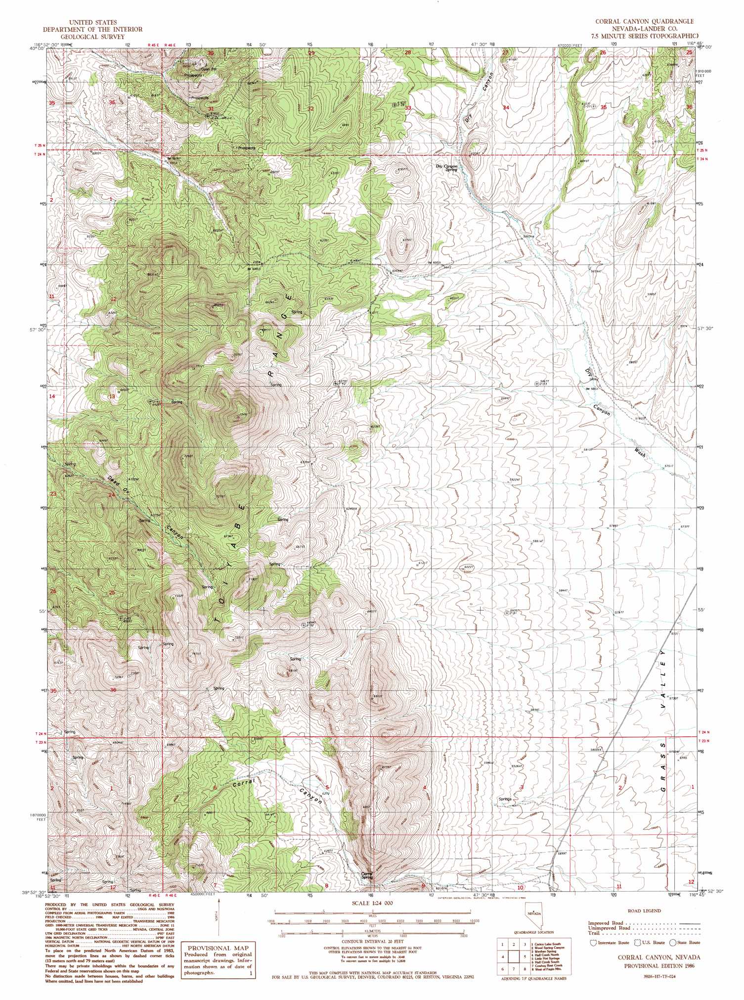
USGS Topo Quad 39116h7 - 1:24,000 scale
| Topo Map Name: | Corral Canyon |
| USGS Topo Quad ID: | 39116h7 |
| Print Size: | ca. 21 1/4" wide x 27" high |
| Southeast Coordinates: | 39.875° N latitude / 116.75° W longitude |
| Map Center Coordinates: | 39.9375° N latitude / 116.8125° W longitude |
| U.S. State: | NV |
| Filename: | o39116h7.jpg |
| Download Map JPG Image: | Corral Canyon topo map 1:24,000 scale |
| Map Type: | Topographic |
| Topo Series: | 7.5´ |
| Map Scale: | 1:24,000 |
| Source of Map Images: | United States Geological Survey (USGS) |
| Alternate Map Versions: |
Corral Canyon NV 1986, updated 1986 Download PDF Buy paper map Corral Canyon NV 2012 Download PDF Buy paper map Corral Canyon NV 2014 Download PDF Buy paper map |
1:24,000 Topo Quads surrounding Corral Canyon
Moss Creek |
Carico Lake North |
Rocky Pass |
Cortez Canyon |
Cortez |
The Cedars |
Carico Lake South |
Wood Spring Canyon |
Wenban Spring |
Dugout Spring |
Manhattan Mountain Ne |
Hall Creek North |
Corral Canyon |
Little Hot Springs |
Walti Hot Springs |
Joe Eason Mountain |
Hall Creek South |
Cowboy Rest Creek |
West Of Fagin Mountain |
Fagin Mountain |
Vigus Butte Ne |
Mount Callaghan |
Grass Valley Ranch |
Salt Marsh Canyon |
Shagnasty |
> Back to 39116e1 at 1:100,000 scale
> Back to 39116a1 at 1:250,000 scale
> Back to U.S. Topo Maps home
Corral Canyon topo map: Gazetteer
Corral Canyon: Springs
Corral Spring elevation 1885m 6184′Dry Canyon Spring elevation 1775m 5823′
Dry Canyon Spring elevation 1817m 5961′
Rocky Mountain Spring elevation 1991m 6532′
Rocky Mountain Spring Number One elevation 1946m 6384′
Corral Canyon: Valleys
Corral Canyon elevation 1817m 5961′Dry Canyon elevation 1799m 5902′
Corral Canyon digital topo map on disk
Buy this Corral Canyon topo map showing relief, roads, GPS coordinates and other geographical features, as a high-resolution digital map file on DVD: