North Toiyabe Peak Topo Map Nevada
To zoom in, hover over the map of North Toiyabe Peak
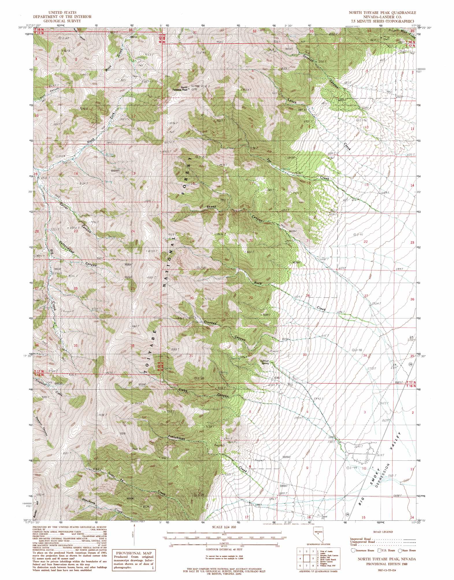
USGS Topo Quad 39117c1 - 1:24,000 scale
| Topo Map Name: | North Toiyabe Peak |
| USGS Topo Quad ID: | 39117c1 |
| Print Size: | ca. 21 1/4" wide x 27" high |
| Southeast Coordinates: | 39.25° N latitude / 117° W longitude |
| Map Center Coordinates: | 39.3125° N latitude / 117.0625° W longitude |
| U.S. State: | NV |
| Filename: | o39117c1.jpg |
| Download Map JPG Image: | North Toiyabe Peak topo map 1:24,000 scale |
| Map Type: | Topographic |
| Topo Series: | 7.5´ |
| Map Scale: | 1:24,000 |
| Source of Map Images: | United States Geological Survey (USGS) |
| Alternate Map Versions: |
North Toiyabe Peak NV 1988, updated 1988 Download PDF Buy paper map North Toiyabe Peak NV 2012 Download PDF Buy paper map North Toiyabe Peak NV 2015 Download PDF Buy paper map |
| FStopo: | US Forest Service topo North Toiyabe Peak is available: Download FStopo PDF Download FStopo TIF |
1:24,000 Topo Quads surrounding North Toiyabe Peak
Mount Airy Mesa |
Vigus Butte |
Yankee Blade |
Barton Spring |
Bates Mountain |
Gandolfo Canyon |
West Of Austin |
Austin |
Simpson Park Canyon |
Cape Horn |
Dutch Flat |
Bunker Hill |
North Toiyabe Peak |
Birch Creek Ranch |
Spencer Hot Springs |
Reese River Butte |
Brewer Canyon |
Kingston |
Wildcat Peak Nw |
Petes Summit |
Tierney Creek |
Millett Ranch |
East Of Millett Ranch |
Wildcat Canyon |
Wildcat Peak |
> Back to 39117a1 at 1:100,000 scale
> Back to 39116a1 at 1:250,000 scale
> Back to U.S. Topo Maps home
North Toiyabe Peak topo map: Gazetteer
North Toiyabe Peak: Gaps
Kingston Summit elevation 2644m 8674′North Toiyabe Peak: Mines
Blue Horizon Mine elevation 2398m 7867′Bray Beulah Mine elevation 2425m 7956′
Bray Mine elevation 2551m 8369′
Bull Dog Jack Mine elevation 2999m 9839′
Cahill Mine elevation 1919m 6295′
Deer Point Mine elevation 2123m 6965′
Hard Luck-Pradier Mine elevation 2405m 7890′
Limelight Mine elevation 2664m 8740′
Lynch Creek Mine elevation 2401m 7877′
Smoky Valley Mine elevation 2087m 6847′
T-Bone Mine elevation 2490m 8169′
North Toiyabe Peak: Springs
Gillman Spring elevation 1951m 6400′North Toiyabe Peak: Streams
Frenchman Creek elevation 1721m 5646′North Fork Big Creek elevation 2107m 6912′
Rock Creek elevation 1859m 6099′
North Toiyabe Peak: Summits
North Toiyabe Peak elevation 3261m 10698′North Toiyabe Peak: Valleys
Cahills Cañon elevation 2017m 6617′Cahills North Cañon elevation 2136m 7007′
Corral Canyon elevation 2158m 7080′
Cottonwood Canyon elevation 2219m 7280′
Crooked Canyon elevation 1776m 5826′
Globe Canyon elevation 1738m 5702′
Sheep Canyon elevation 1785m 5856′
Spanish Canyon elevation 1860m 6102′
North Toiyabe Peak digital topo map on disk
Buy this North Toiyabe Peak topo map showing relief, roads, GPS coordinates and other geographical features, as a high-resolution digital map file on DVD: